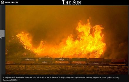
BlueCut Fire 8-16-2016 (Cajon Pass)
SCM ALERT🚨, Tue Aug 16 2016, 12:15PM
FIRE STARTED: TUE AUG 16, 2016, 10:55 AM
NOW AT OVER 1000 ACRES MOVING UP LONE PINE CANYON - LIFE AND PROPERTY THREAT
EVACUATIONS: All Areas south of Hwy 2 (Lone Pine Canyon and Swarthout Canyon)
Re: BlueCut Fire 8-16-2016 (Cajon Pass)
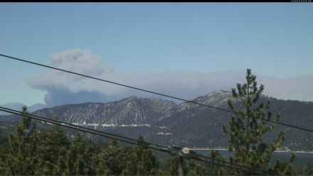
SCM ALERT🚨, Tue Aug 16 2016, 12:20PM
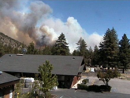
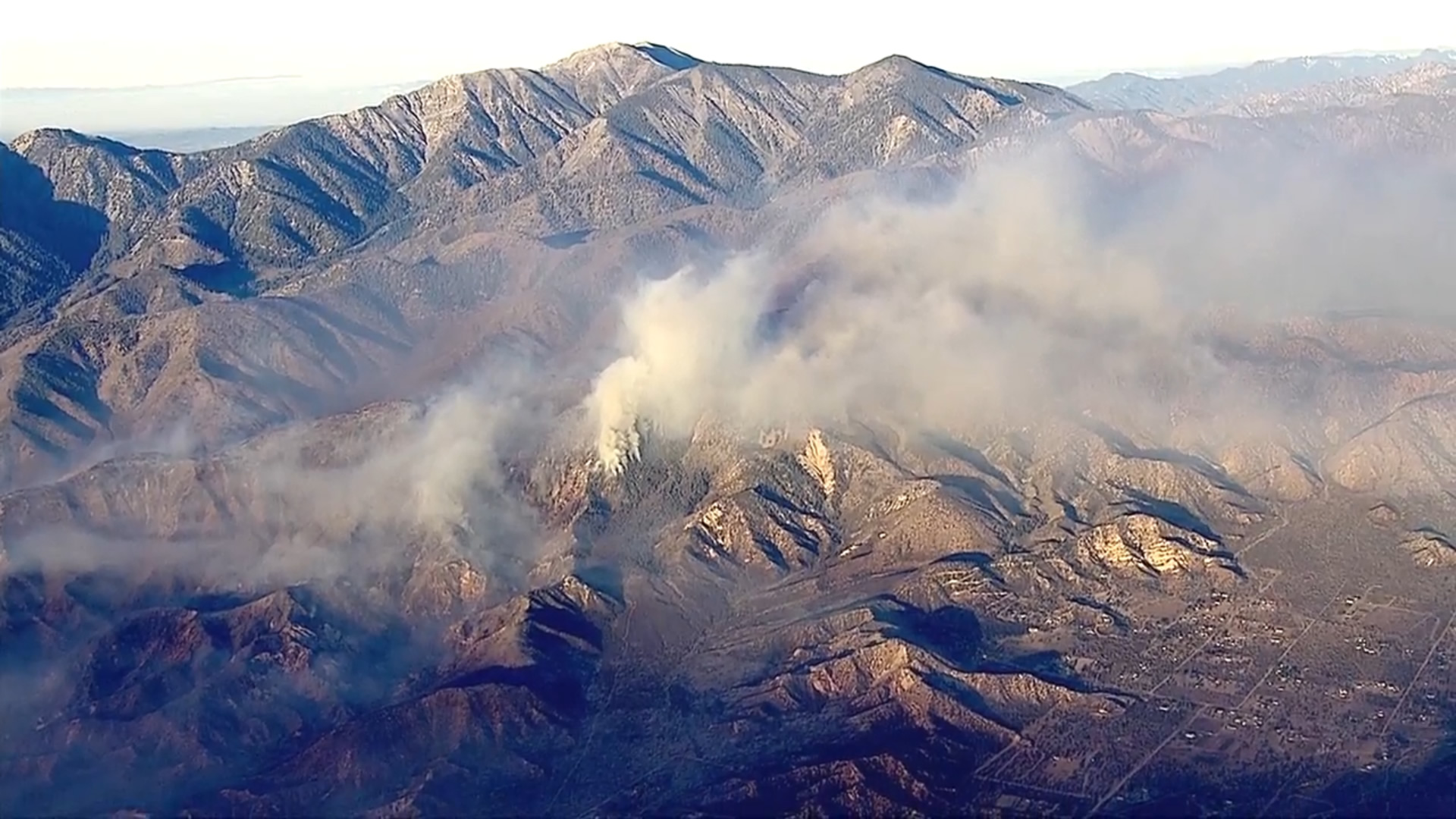
Here's the live shot from the #ktla camera located at Snow Summit, updated every 10 minutes... [Click Here]
Re: BlueCut Fire 8-16-2016 (Cajon Pass)
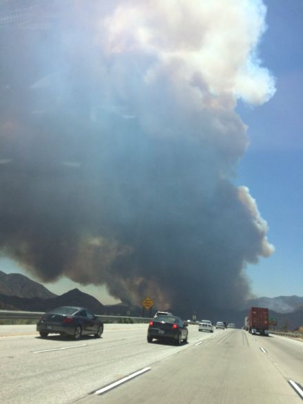
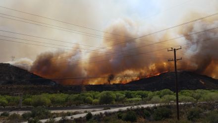
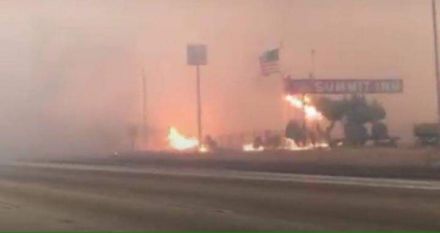
SCM ALERT🚨, Tue Aug 16 2016, 12:21PM
Another photo from a traveler going through Cajon, couresty wrightwoodcalif.com [Click Here]
Re: BlueCut Fire 8-16-2016 (Cajon Pass)
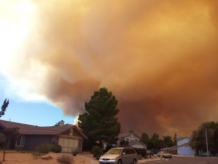
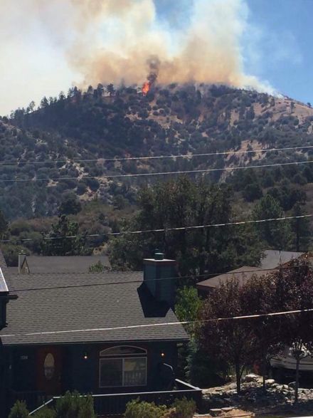
BrownBear, Tue Aug 16 2016, 12:55PM
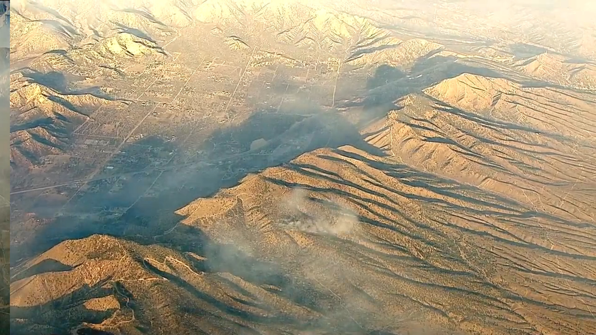
Getting tired of posting this kind of view from Hesperia! God bless our firemen and all the authorities involved
Re: BlueCut Fire 8-16-2016 (Cajon Pass)
SCM ALERT🚨, Tue Aug 16 2016, 01:01PM
Mandatory Evacuations In Place for:
All area south of Wrightwood all the way to I15 and all canyons in that area.
NEW Mandatory Evac: Lytle Creek - GET OUT NOW
Re: BlueCut Fire 8-16-2016 (Cajon Pass)
SCM ALERT🚨, Tue Aug 16 2016, 02:29PM
Per Wrightwoodcalif.com
Via Facebook:
Snowline Joint Unified School District
23 mins ·
You may be aware that a fire recently started near the I-15 that is currently impacting our district. At this point, the actions we are taking to secure the safety of students and adults are as follows:
Wrightwood ES students are being sent home due to mandatory evacuations in West Cajon Valley and voluntary evacuations in Wrightwood. As of right now, students who are not picked up by 3:45 PM will be transported to Serrano High School.
Students who live in Wrightwood or West Cajon Valley and attend Serrano HS, Chaparral HS, Eagle Summit CDS, Pinon Mesa MS, and Pinon Hills ES will be sent to the Serrano HS gymnasium for parent pickup due to the road closures preventing buses from transporting such students.
All other schools will continue to operate as normal and their students will be transported as usual.
This is rapidly developing situation, so please stay tuned for updates to ensure that the safety of all can be maintain. Your help and support is greatly appreciated.
Thank you,
Ryan Holman
Re: BlueCut Fire 8-16-2016 (Cajon Pass)
SCM ALERT🚨, Tue Aug 16 2016, 03:01PM
ACREAGE 5500
TUE AUG 16, 2016, 10:55 AM (UPDATED: 2:52 PM)
VEGETATION FIRE
CAJON PASS, CAJON PASS
2ND ALARM VEGETATION FIRE INTERSTATE 15 NEAR CLEGHORN (OLD CAJON)ML12
INCIDENT NAME: BLUECUT
LIVE WEBCAM (FROM BIG BEAR): [Click Here]
MANDATORY EVACUATIONS:
Lone Pine Canyon
Swarthouth Canyon
Lytle Creek
Hwy 138 WEST of I15 North to Phelan Road
Ranchero Rd to Summit Valley EAST of I15
VOLUNTARY EVACS:
Town of Wrightwood
LARGE ANIMAL EVACUATIONS: VICTORVILLE FAIRGROUNDS
READY! SET! GO! CLICK HERE: [Click Here]
NOTE: US FOREST SERVICE HAS BEEN REQUESTED TO RESPOND TO THIS INCIDENT
NOTE: CALFIRE HAS BEEN REQUESTED TO RESPOND TO THIS INCIDENT
UNITS RESPONDING: BC121 I165 BE226 BE228 ME225 BE75 ME241 GLEN HELEN CREW15-2 GLEN HELEN CREW15-3 FEDCOM (FOREST SERVICE) SUP15 BC912 BC125 WT77 WT175 BE23 BE9 ME22 FEDCOM (FOREST SERVICE) CALCOM (CALFIRE) (SAN BERNARDINO NATIONAL FOREST SERVICE )
CLICK HERE FOR DETAILS EDIT
Re: BlueCut Fire 8-16-2016 (Cajon Pass)
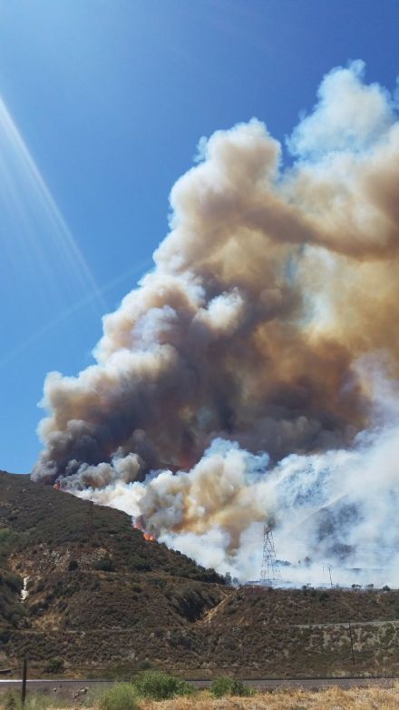
SCM ALERT🚨, Tue Aug 16 2016, 03:09PM
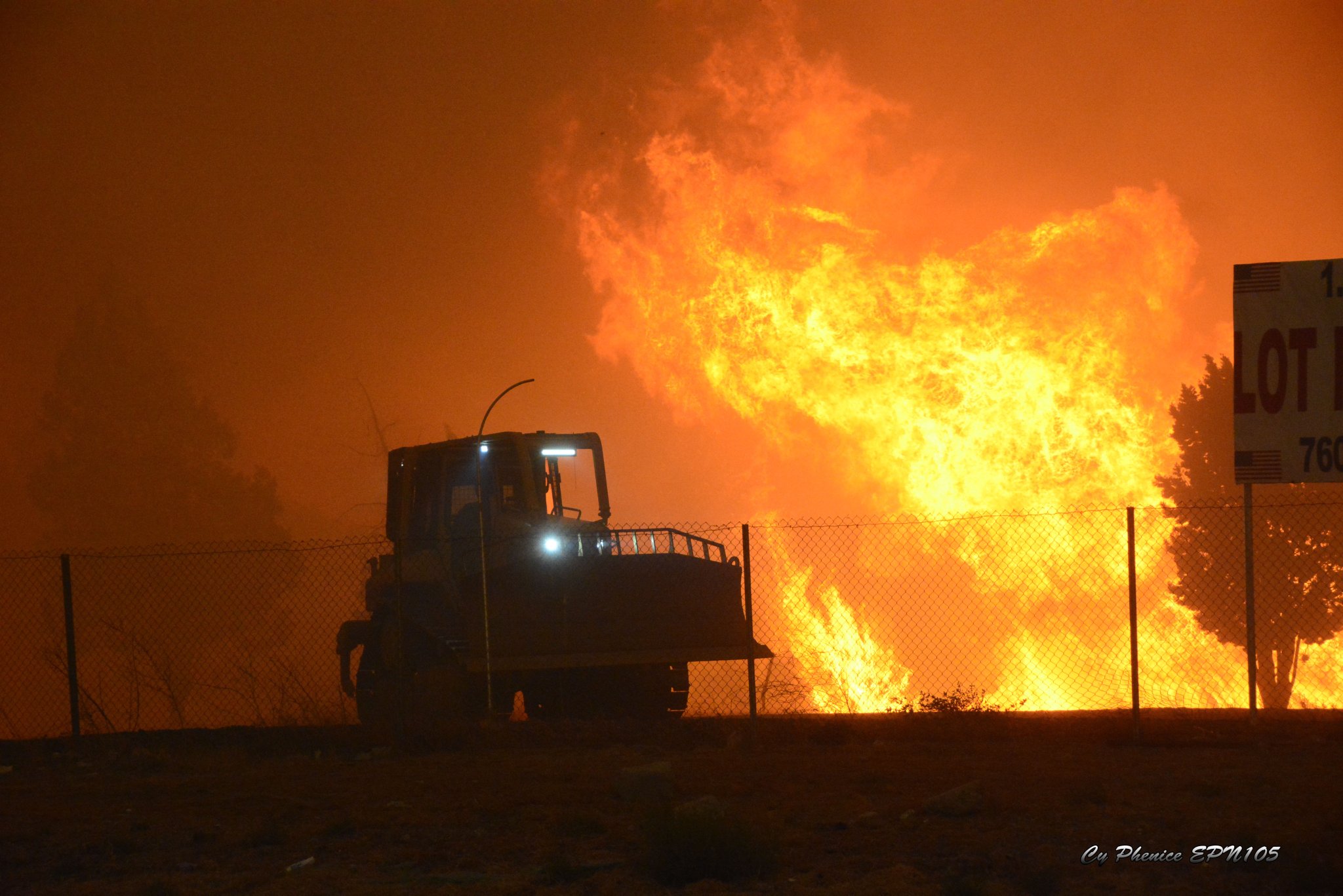
We have our SCM photographer in the field and will be posting additional photos as they come to us... Courtesy Member: (Cy)FirePhoto84 - @EPN105
Re: BlueCut Fire 8-16-2016 (Cajon Pass)
SCM ALERT🚨, Tue Aug 16 2016, 03:19PM
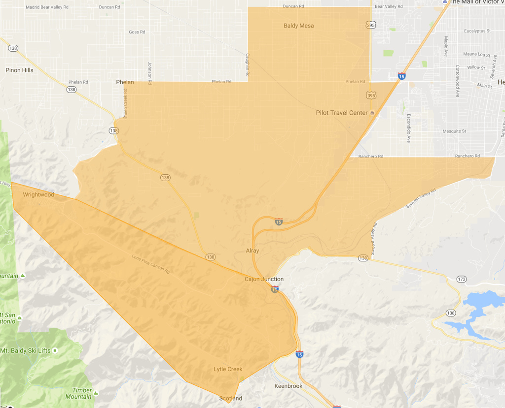
#BlueCutFire - Mandatory evacuations for the community of Baldy Mesa north of Phelan Road.
Re: BlueCut Fire 8-16-2016 (Cajon Pass)
SCM ALERT🚨, Tue Aug 16 2016, 03:25PM
EVACUATIONS HAVE GONE TO MANDATORY FOR THE ENTIRE COMMUNITY OF WRIGHTWOOD!
EVERYONE should be reviewing this SB County Fire Document no matter if you are in danger, could be in danger, or don't think you will ever be in danger. Ready, Set, GO! [Click Here]
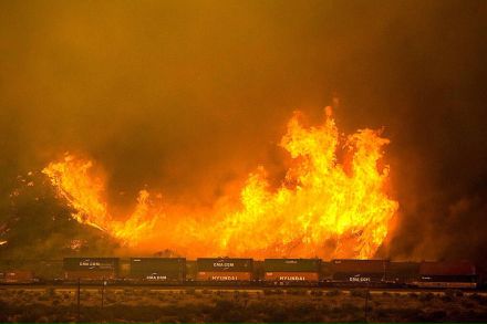
Re: BlueCut Fire 8-16-2016 (Cajon Pass)
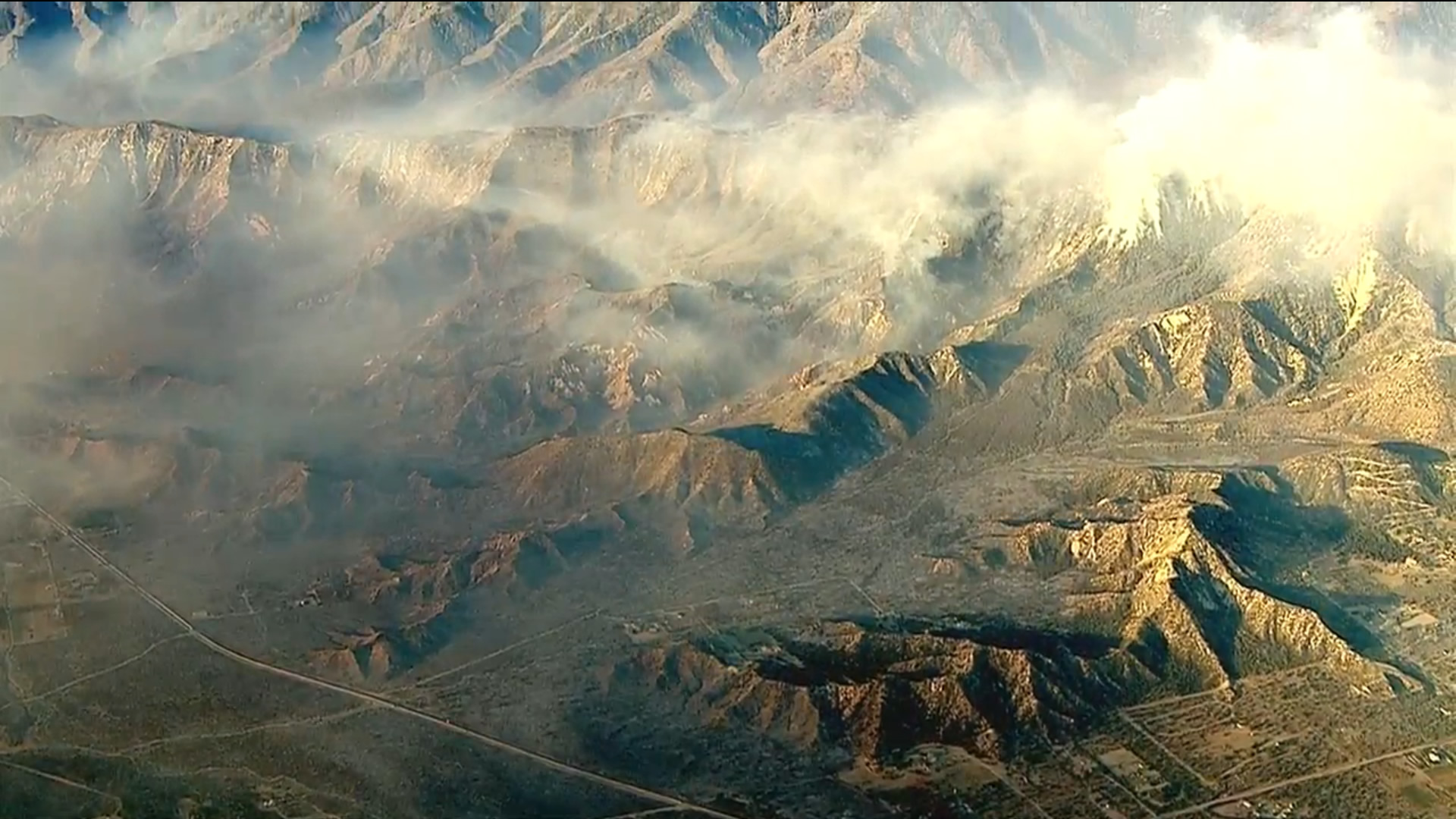
Dragon, Tue Aug 16 2016, 03:44PM
Various pics from the ABC chopper [Click Here] taken between 3 and 3:15pm:
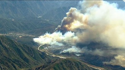
This one has grown quickly to a gigantic scale and I've seen structures already reduced to ash in one part of the video (didn't get a screenshot of it unfortunately). High winds were dispersing fire retardant till it seemed to disappear behind the flames instead of landing ahead of the flames. It looks like winds may have calmed in the current video (3:45).
Re: BlueCut Fire 8-16-2016 (Cajon Pass)
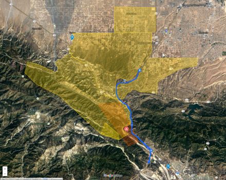
SCM ALERT🚨, Tue Aug 16 2016, 04:48PM
Evacuation Area Map thanks to SCPR.org (full link to map below)
[Click Here]
(click to enlarge)
Re: BlueCut Fire 8-16-2016 (Cajon Pass)
SCM ALERT🚨, Tue Aug 16 2016, 04:55PM
Firefighters Entrapped By Raging Wildfire
Initial Date/Time: August 16, 2016, 10:36 a.m.
Location: Swarthout Canyon, Cajon Pass
Incident: Blue Cut Fire
Cajon Pass, CA – Six firefighters became entrapped by wildfire today while defending homes and assisting evacuations in the Swarthout Canyon area west of Cajon Pass. The six firefighters were part of two San Bernardino County Fire (SBCoFD) engine companies assigned to the area northwest of Cajon Blvd.
Firefighters were able to shelter in place within a nearby structure, but two firefighters sustained minor injuries. Both firefighters were transported to a local hospital where they were treated and released and are now back on the fire line defending structures. One SBCoFD fire engine sustained moderate fire damage.
SBCoFD reminds residents to be prepared and know your evacuation routes. An evacuation order can save your life, leave as soon as evacuations orders are given by fire and law enforcement officials to avoid being caught in fire, smoke or road congestion. Residents that refuse to evacuate put their own and other people’s lives at risk.
Visit sbcfire.org/ReadySetGo.aspx for fire preparedness and safety information. For more information on the Blue Cut Fire, call 909-383-5688 or visit [Click Here]
Re: BlueCut Fire 8-16-2016 (Cajon Pass)
SCM ALERT🚨, Tue Aug 16 2016, 04:58PM
PER SBNF: RESOURCES ON THE FIRE INCLUDE 102 ENGINES, 15 CREWS (OF 30 FIREFIGHTERS EACH), 8 HELICOPTERS, 8 AIR TANKERS, AND 2 VLATS (VERY LARGE AIR TANKERS) - 750 PERSONNEL ON SCENE AT THIS TIME WITH MANY MORE RESOURCES ON THE WAY
Re: BlueCut Fire 8-16-2016 (Cajon Pass)
Dragon, Tue Aug 16 2016, 05:12PM
Burn and evac area map from sbsun.com. This looks like the fire area from like 1 or 2pm. I think it's crossed 138 and the 15 to the north by now.
Re: BlueCut Fire 8-16-2016 (Cajon Pass)
SCM ALERT🚨, Tue Aug 16 2016, 05:30PM
Duplicate post, it's posted 2 above yours...
Re: BlueCut Fire 8-16-2016 (Cajon Pass)
Dragon, Tue Aug 16 2016, 05:42PM
Pics from 5:30pm. The second is panned left of the first. I don't know what road that is or what location this was taken from:
Re: BlueCut Fire 8-16-2016 (Cajon Pass)
Dragon, Tue Aug 16 2016, 05:44PM
Previous post doesn't include the burn area as far as I can tell.
Re: BlueCut Fire 8-16-2016 (Cajon Pass)
SCM ALERT🚨, Tue Aug 16 2016, 05:48PM
True but that's off as well, the fire's near doubled the size of your post.
Re: BlueCut Fire 8-16-2016 (Cajon Pass)
Dragon, Tue Aug 16 2016, 05:49PM
Chopper moved to a different vantage point. First pic is panned left, second is panned right. 5:45pm:
Re: BlueCut Fire 8-16-2016 (Cajon Pass)
chekkasan, Tue Aug 16 2016, 05:51PM
Chekkasan checking in:
Traffic the back way is bumper to bumper, but moving both ways!
Re: BlueCut Fire 8-16-2016 (Cajon Pass)
SCM ALERT🚨, Tue Aug 16 2016, 05:52PM
Chekka, what's your location?
Re: BlueCut Fire 8-16-2016 (Cajon Pass)
Cap'n Crunch, Tue Aug 16 2016, 06:11PM
Just a guess but the first picture looks like it might have been taken from above Phelan looking SE. If so, the larger road on the left could be a portion of HWY 138?
Re: BlueCut Fire 8-16-2016 (Cajon Pass)
bills grandson, Tue Aug 16 2016, 06:16PM
It might just be me but when I look at them it looks like the smoke is moving
Re: BlueCut Fire 8-16-2016 (Cajon Pass)
SCM ALERT🚨, Tue Aug 16 2016, 06:34PM
Quick Flash Report update @ 6:30pm:
#BlueCutFire in Cajon Pass (San Bernardino Co) is 9000 acres, 0% contained, 82,000 residents under mandatory evac.
Re: BlueCut Fire 8-16-2016 (Cajon Pass)
SCM ALERT🚨, Tue Aug 16 2016, 06:49PM
The header and plume from this fire has made it all the way up to 20,000-30,000 feet. At times a pyrocumulus.
Radar Link [Click Here]
And of course it's very visible on the visible satellite loop, reaching all the way out to Las Vegas... [Click Here]
Re: BlueCut Fire 8-16-2016 (Cajon Pass)
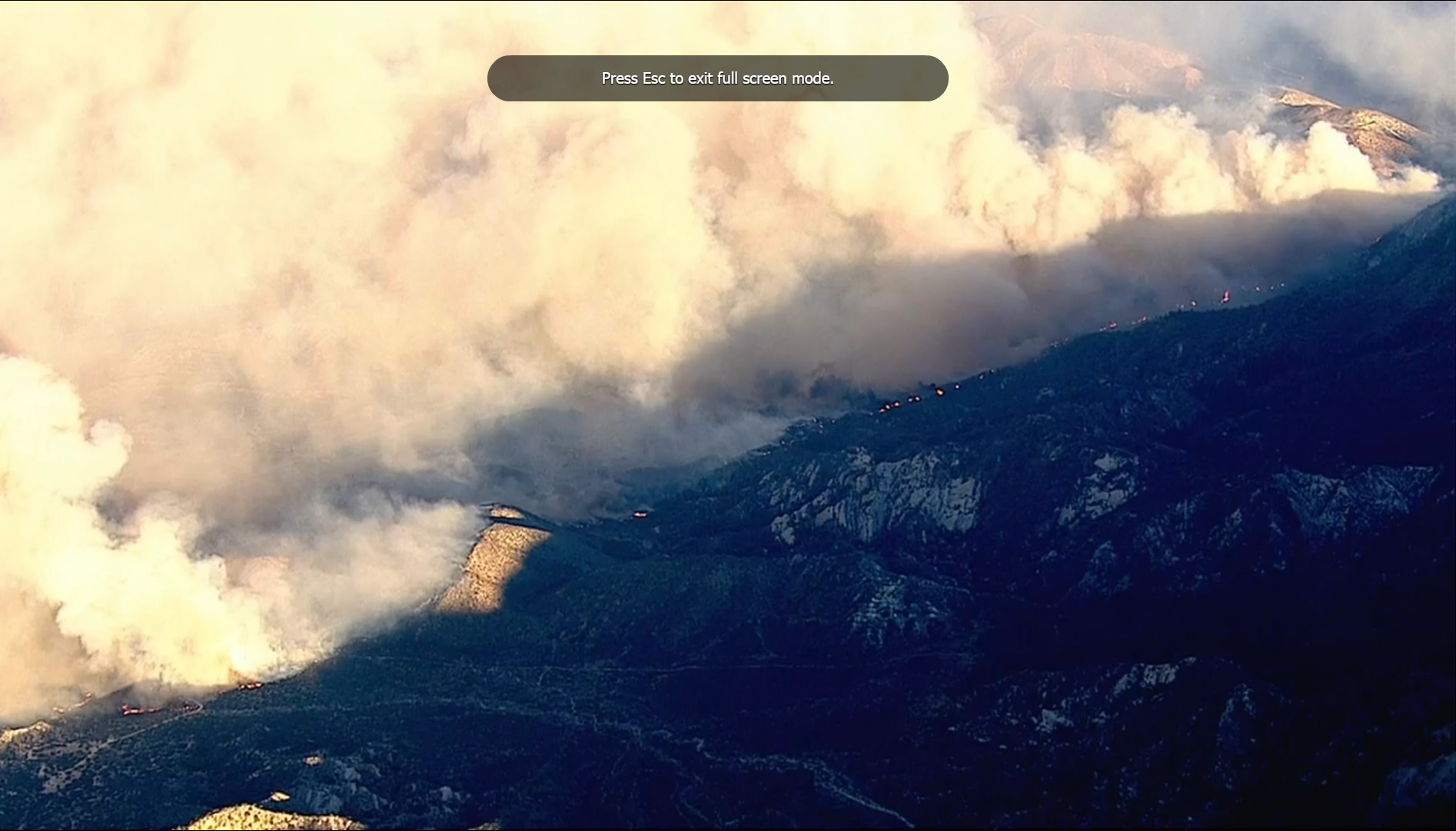
Dragon, Tue Aug 16 2016, 06:59PM
Looking northwest from just S of Cajon Junction (around 34.310723, -117.473607). I-15 goes up right, 138 goes up left. McDonalds being threatened is just off camera in the lower right corner.

Re: BlueCut Fire 8-16-2016 (Cajon Pass)
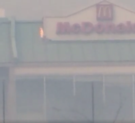
SCM ALERT🚨, Tue Aug 16 2016, 07:07PM
The McDonalds actually did catch fire, but I didn't hear if they saved it or not. Photo from KTLA...

Re: BlueCut Fire 8-16-2016 (Cajon Pass)
Dragon, Tue Aug 16 2016, 07:10PM
I've been trying to use Google Earth to match some of the images but no luck so far. In the two pics before the Cajon Junction pics they swung the camera 180 and I thought I saw Silverwood Lake, which puts them between silverwood and 15, but I couldn't match it to Google Earth.
Re: BlueCut Fire 8-16-2016 (Cajon Pass)
Dragon, Tue Aug 16 2016, 07:29PM
Here's two more I really wish I could match on Google Earth because the terrain looks like Crestline area (where I am). I suspect it's on the Wrightwood side but can't match it. The second image is panned a bit up and right from the first and the terrain is much darker (underexposed).

Re: BlueCut Fire 8-16-2016 (Cajon Pass)
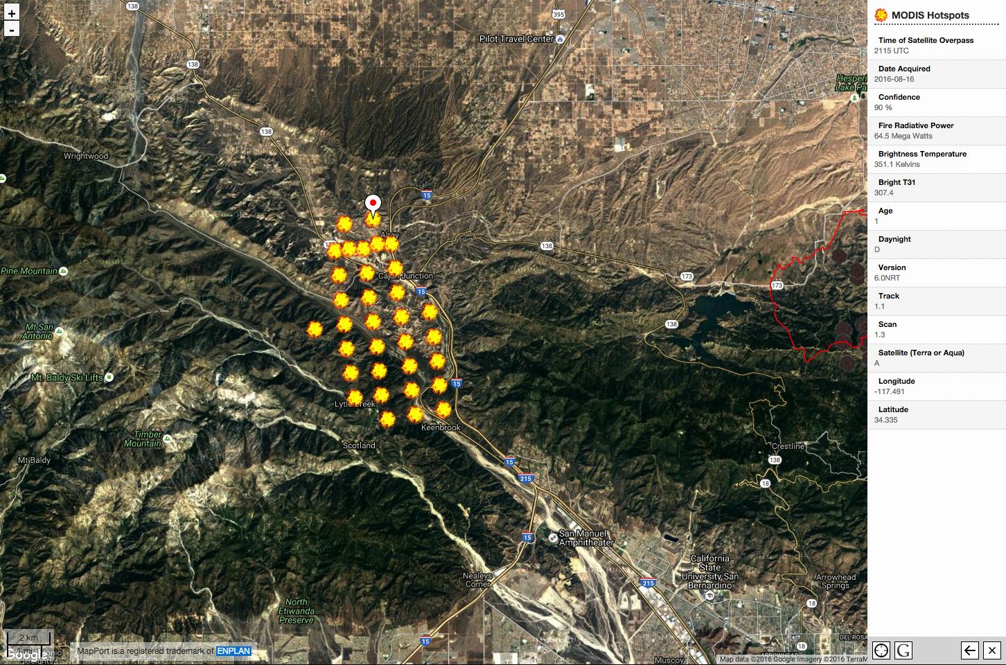
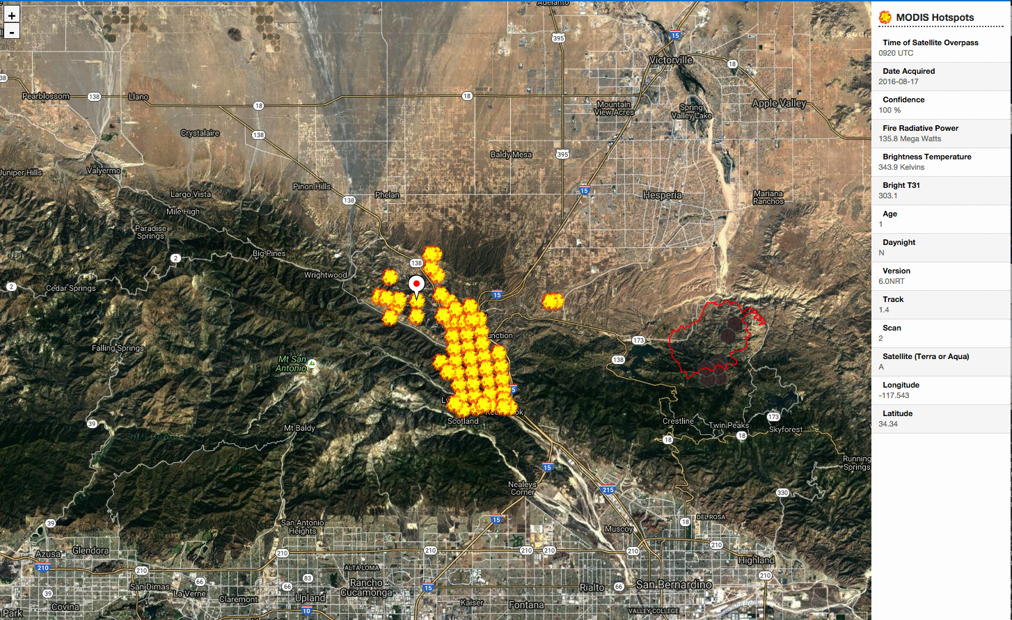
Dragon, Tue Aug 16 2016, 07:56PM
MODIS hot spots, 2:15pm:

Re: BlueCut Fire 8-16-2016 (Cajon Pass)
robk (K6RBK), Tue Aug 16 2016, 08:02PM
That top photo appears to be looking SE at a point just NE of the intersection of Macapa Road and Stone Basin Road, approximately 34° 21.154'N by 117° 32.788'W.
Looks like Stone Basin road running through the lower part of the photo, and also making that 90 degree turn in the lower left of the photo.
Rob
Re: BlueCut Fire 8-16-2016 (Cajon Pass)
⚡WX ALERT⚡, Tue Aug 16 2016, 08:06PM
Here's a picture at sunset from the Baldy Mesa area...
Re: BlueCut Fire 8-16-2016 (Cajon Pass)
BrownBear, Tue Aug 16 2016, 08:25PM
It hurts to see this. Someone posted this to facebook
Re: BlueCut Fire 8-16-2016 (Cajon Pass)
⚡WX ALERT⚡, Tue Aug 16 2016, 08:33PM
8:30pm Flash Report per Calfire PIO
#BlueCutFire in the Cajon Pass (San Bernardino County) is now 15,000 acres, 0% contained. 15 & 138 remain closed.
Photo: @crimeshutterbug
Re: BlueCut Fire 8-16-2016 (Cajon Pass)
DHRacer, Tue Aug 16 2016, 08:35PM
Just FYI for mountain residents. 18 north to Crestline is jacked up. Go 330, much better then backtrack west on the 18 to communities like Twin Peaks, Crestline, etc. I was almost going to go 38 into Big Bear if both 18 and 330 were a mess but only the 18 was.
DHR
Re: BlueCut Fire 8-16-2016 (Cajon Pass)
SCM ALERT🚨, Tue Aug 16 2016, 08:54PM
Thank you DHRacer!
Re: BlueCut Fire 8-16-2016 (Cajon Pass)
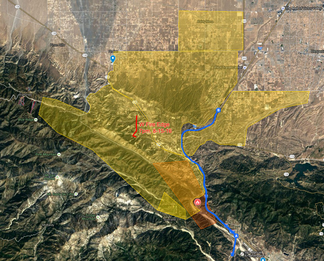
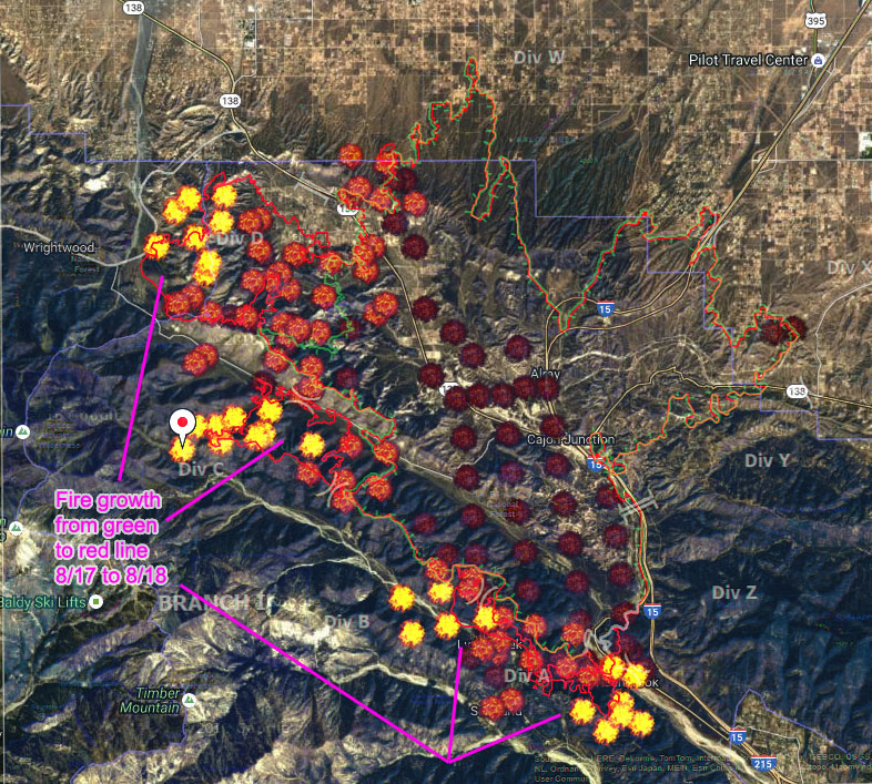
Dragon, Tue Aug 16 2016, 09:02PM
Wow, you're totally right! I couldn't find it because the sun in Google maps makes that distinctive rock pattern look very different, but all the roads line up perfectly. So I used Google Earth to click points that match the fire line in the photo to trace this approximate western edge of the fire as of 7pm:

Fire edge is the red line and I overlaid it on the image of the evac area with the old fire border for comparison. Hopefully the low winds will let them get a line around it... but bad terrain and no roads or aircraft makes that seem a little hopeless... =(
Re: BlueCut Fire 8-16-2016 (Cajon Pass)
Cap'n Crunch, Tue Aug 16 2016, 09:32PM
Here is an updated map of the fire footprint.
[Click Here]
Re: BlueCut Fire 8-16-2016 (Cajon Pass)
Lumber Jill, Wed Aug 17 2016, 06:05AM
We may not get much new info before 9am. From the Forest Service:
MEDIA ADVISORY
U.S. Forest Service, San Bernardino National Forest
For Immediate Release
Contact: Fire Information Center at (909) 383-5688
Twitter: @sanbernardinonf
Blue Cut Fire Press Conference Scheduled
SAN BERNARDINO, Calif., August 16, 2016 – The Unified Incident Command Agencies will speak to the media regarding the Blue Cut incident.
The Press Conference is set for 9:00 A.M. on Wednesday August 16, 2016 at the Glen Helen Regional Park located at 2555 Glen Helen Parkway, San Bernardino, CA 92407.
Speakers will include:
California Highway Patrol
CALFIRE Inyo Mono San Bernardino Unit
Caltrans District 8
San Bernardino County Fire Department
San Bernardino County Sheriff’s Department
U.S. Forest Service
Re: BlueCut Fire 8-16-2016 (Cajon Pass)
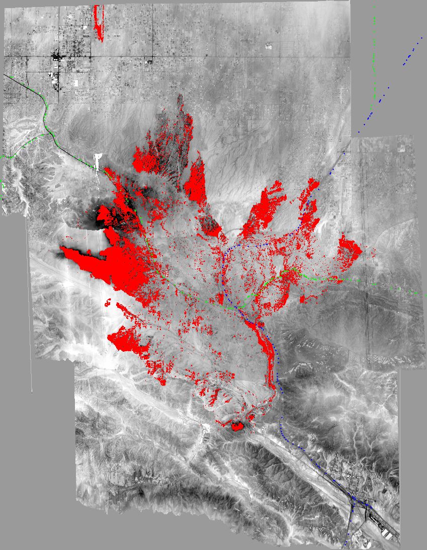
Dragon, Wed Aug 17 2016, 06:08AM
MODIS data from 2:20am showing approximate fire footprint:

Re: BlueCut Fire 8-16-2016 (Cajon Pass)
Mtngoat John⭐, Wed Aug 17 2016, 06:21AM
OPS Map from Inciweb in case this link is broken
[Click Here]
Re: BlueCut Fire 8-16-2016 (Cajon Pass)
Lumber Jill, Wed Aug 17 2016, 07:24AM
[Click Here]
30,000 acres, 0% containment
Re: BlueCut Fire 8-16-2016 (Cajon Pass)
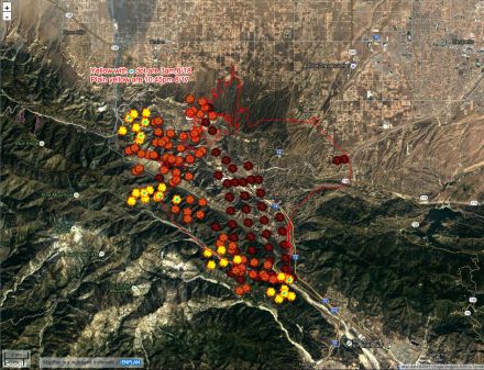
SCM ALERT🚨, Wed Aug 17 2016, 07:25AM
Mosaic Heat Map BlueCut Fire
(click to enlarge)

Re: BlueCut Fire 8-16-2016 (Cajon Pass)
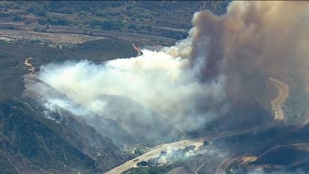
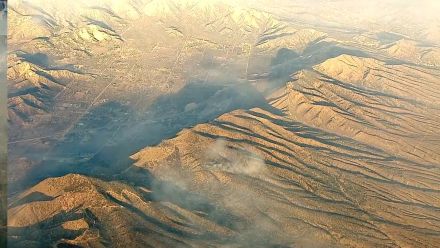
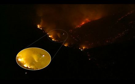
Dragon, Wed Aug 17 2016, 08:18AM
Captures from the ABC chopper at 7am showing most active burning towards Wrightwood. The 138 is the most visible road in the lower left, the camera is looking SSW, and the densest smoke is coming from around 34.338966, -117.565141 GPS coordinates (based on matching the view on Google Earth):


This shows 138 before it rises to intersect highway 2 at the top of the hill towards the top right. A lot of areas along 138 in this image were burned, but it's not easy to see from this distance. It surprises me how little smoke there is.
Re: BlueCut Fire 8-16-2016 (Cajon Pass)
SCM ALERT🚨, Wed Aug 17 2016, 08:25AM
Some bulldozer work from last night...

Re: BlueCut Fire 8-16-2016 (Cajon Pass)
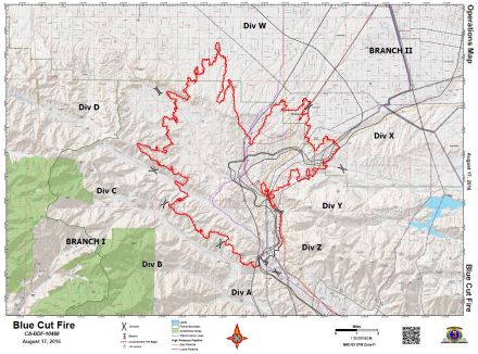
Craig ⭐, Wed Aug 17 2016, 08:27AM
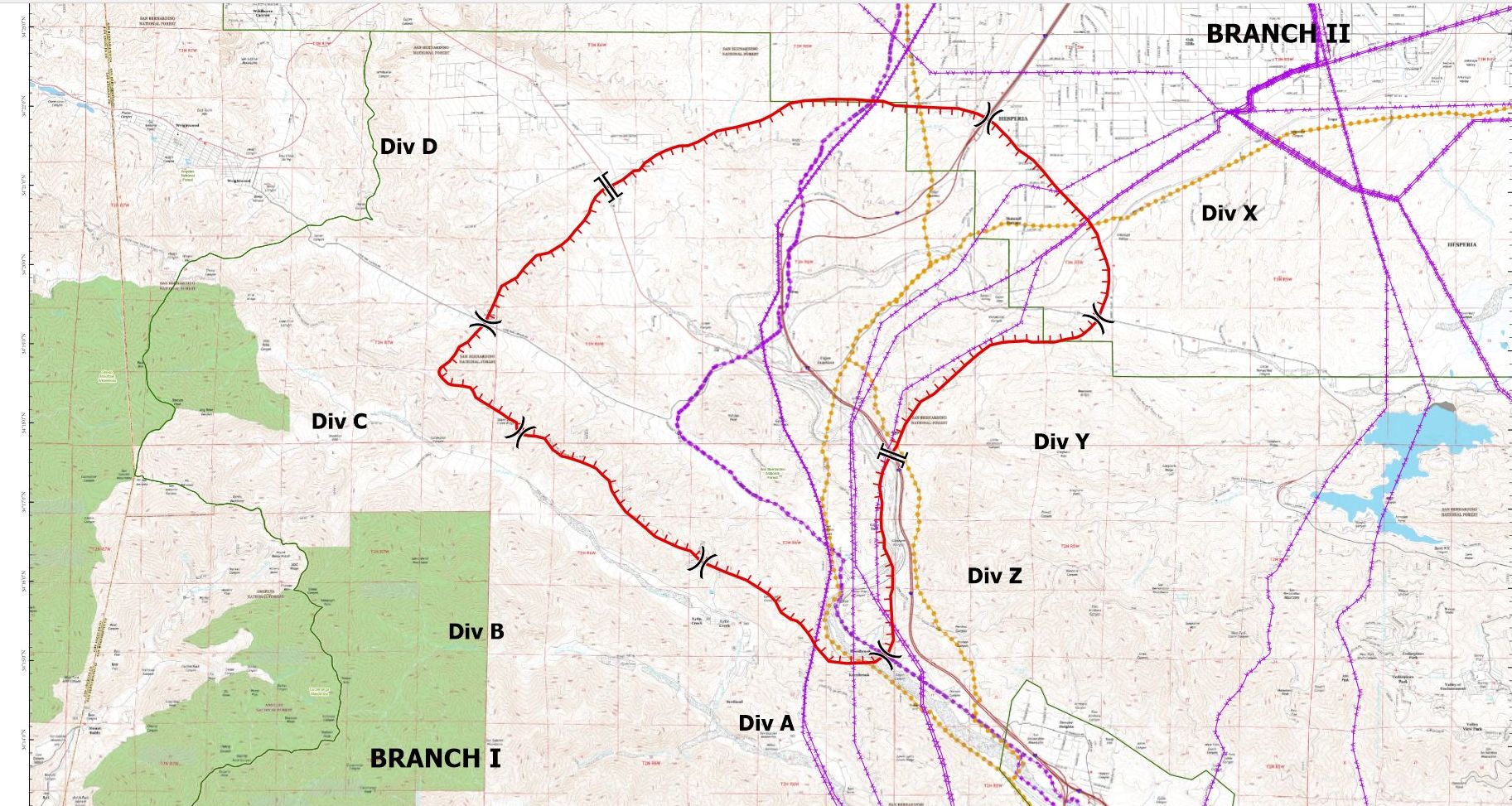
BlueCut Operational Map for Wednesday Aug 17th
(Click to enlarge)
Re: BlueCut Fire 8-16-2016 (Cajon Pass)
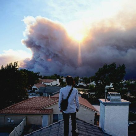
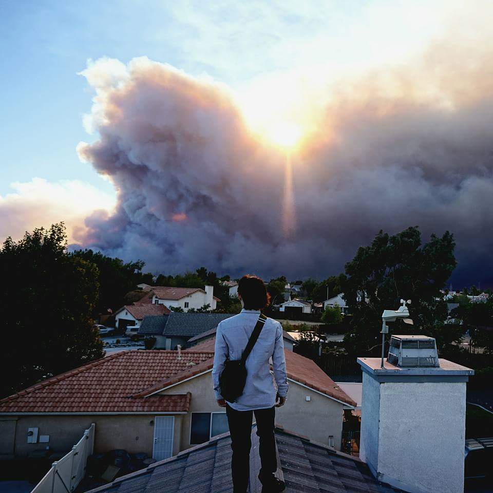
BrownBear, Wed Aug 17 2016, 08:34AM
YESTERDAY.....my son on the roof. You can see why we were all concerned! (And packed up)
Re: BlueCut Fire 8-16-2016 (Cajon Pass)
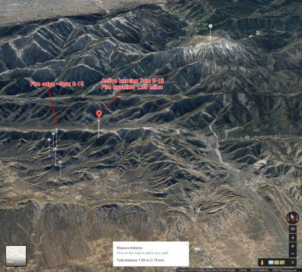
Dragon, Wed Aug 17 2016, 08:38AM
I made a map of the fire progress towards Wrightwood. Looks like it moved about 1.09 miles between 8pm and 7am. There's a wide, flat valley between Wrightwood and the fire where they should be able to stop it, if not earlier.
Re: BlueCut Fire 8-16-2016 (Cajon Pass)
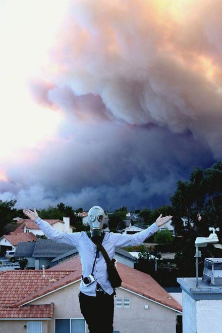
BrownBear, Wed Aug 17 2016, 08:42AM
YESTERDAY. Mask bought for fun/prop but great day to try it on.
Re: BlueCut Fire 8-16-2016 (Cajon Pass)
Dragon, Wed Aug 17 2016, 09:16AM
Highlights from the press conference:
Incident commander says he's never seen fire behavior like this in 40 years.
"Fires are burning at unprecedented rate. Explosive fire growth is the new normal this year."
"It hit with an intensity we haven't seen before and a very wide front."
There is a lot of national infrastructure at risk in Cajon pass.
"If we ask you to leave, you have to leave. The worst thing to happen is if you wait till the last minute, dial 911, fire fighters are unable to get people out of their homes. ... [Please] heed what the Sheriff's department is putting out to you."
100 personnel working on evacuations. Evacuated 35k homes, 80k residents.
Evac area spread west a bit this morning.
15 and 138 still closed. They're doing everything they can to open it as soon as possible. Fire did significant damage to guard rails and power lines. 50 personnel dedicated.
Commercial vehicles have been using 138 and getting stuck, affecting fire ops.
Re: BlueCut Fire 8-16-2016 (Cajon Pass)
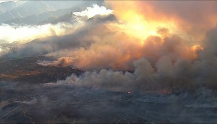
Dragon, Wed Aug 17 2016, 09:38AM
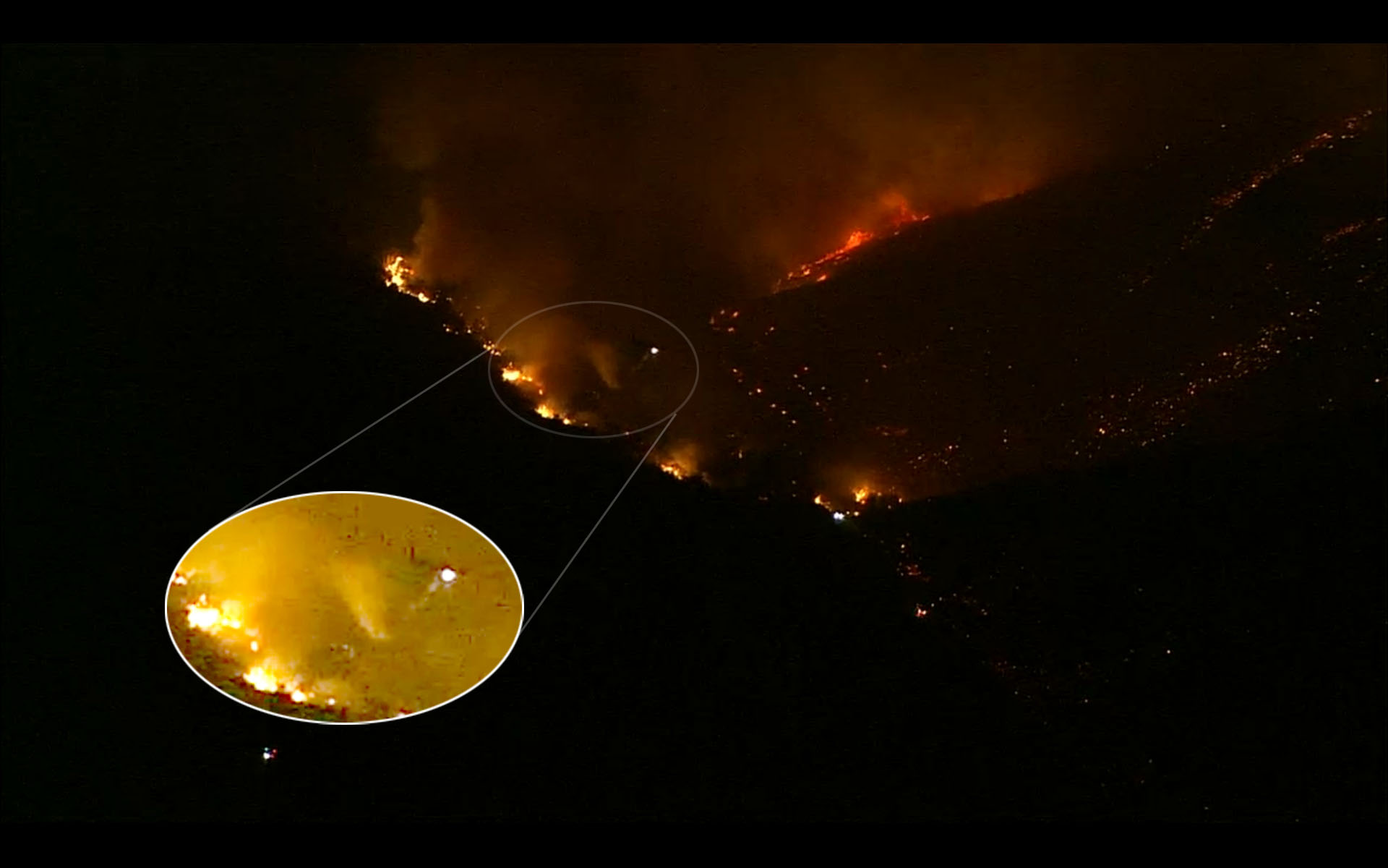
These photos from the ABC chopper yesterday look like a bombing (again, these are from yesterday, not today):

Re: BlueCut Fire 8-16-2016 (Cajon Pass)
SCM ALERT🚨, Wed Aug 17 2016, 10:10AM
Per Inciweb:
There is imminent threat to public safety, rail traffic and structures in the Cajon Pass, Lytle Creek, Wrightwood, Oak Hills, and surrounding areas. Please follow the evacuation instructions, as this is a very quickly growing wildfire. An estimated 34,500 homes and 82,640 people are being affected by the evacuation warnings.
Re: BlueCut Fire 8-16-2016 (Cajon Pass)
BrownBear, Wed Aug 17 2016, 12:56PM
20 mins ago from a Wrightwood neighborhood
Re: BlueCut Fire 8-16-2016 (Cajon Pass)
BrownBear, Wed Aug 17 2016, 01:01PM
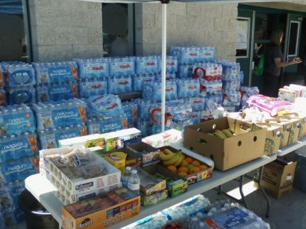
Red Cross providing relief at Sultana High School Hesperia. This time people ARE using this shelter. Husband says they have drinks, and hot food, and info
Re: BlueCut Fire 8-16-2016 (Cajon Pass)
campingmom, Wed Aug 17 2016, 01:12PM
From the cam at Mt. Hardware in Wrightwood

Re: BlueCut Fire 8-16-2016 (Cajon Pass)
NShore.Allen, Wed Aug 17 2016, 01:32PM
From north OC the smoke is coming up behind Baldy
Re: BlueCut Fire 8-16-2016 (Cajon Pass)
Dragon, Wed Aug 17 2016, 01:36PM
I don't know what they're doing on 138 between 18 and top town (a friend implied they were working on the guard rail but I dont think they're putting a guard rail in that stretch) but we avoided it by coming on 18 the whole way from Lake Gregory. No significant traffic. Lots of dark smoke visible off towards Lytle Creek.
Anyone looking for real time traffic updates, turn on the traffic layer turned on using the menu in the top left of Google Maps. That's how we avoided the dark dark red between 18 and top town (actually it extends almost all the way to Lake Gregory and seems to be mostly affecting north bound traffic at this point, causing backup on 18 as people try to get on 138).
Re: BlueCut Fire 8-16-2016 (Cajon Pass)
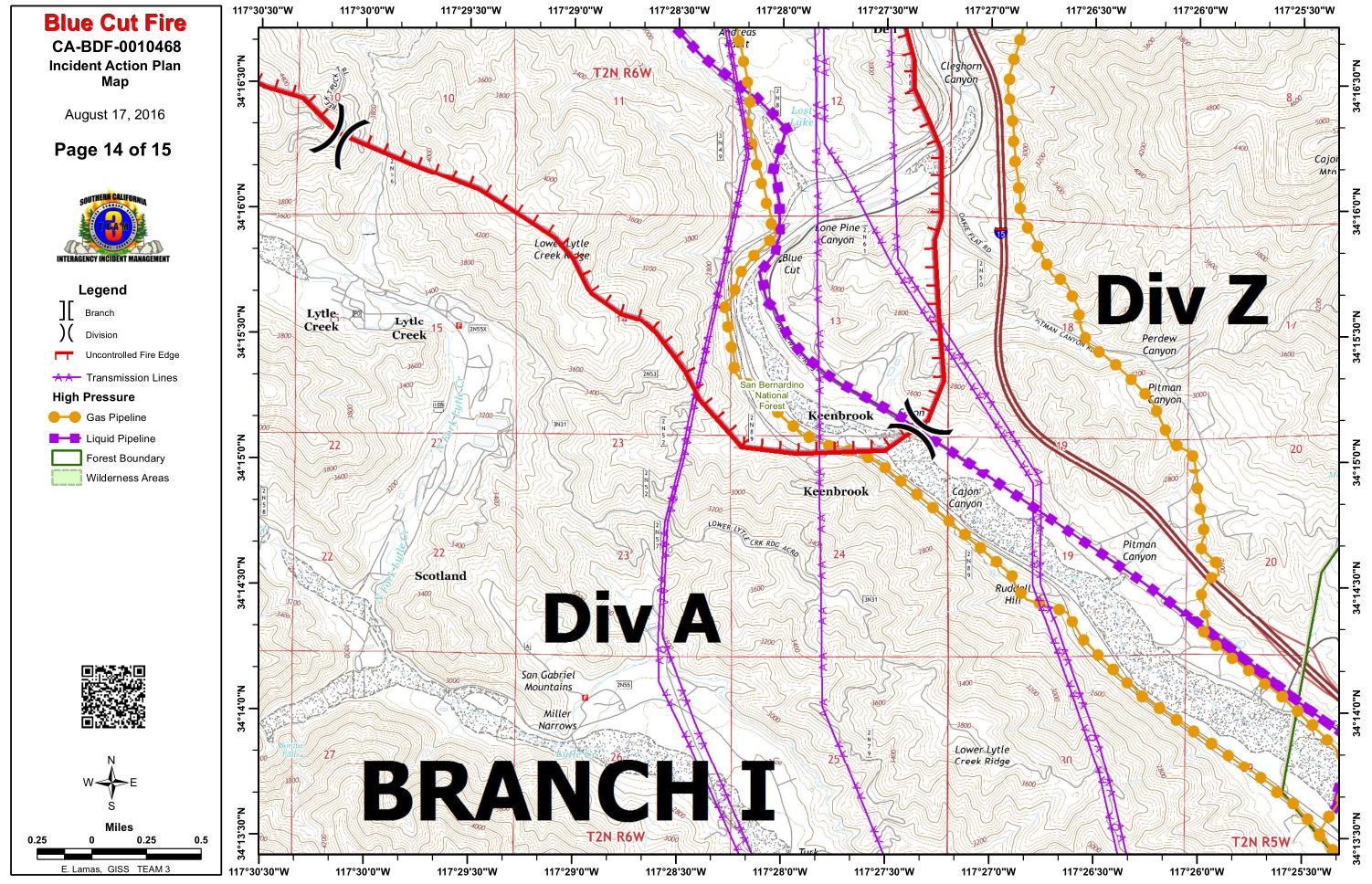
SCM ALERT🚨, Wed Aug 17 2016, 02:22PM
Branch 1 Operational Map
(click to enlarge)

Re: BlueCut Fire 8-16-2016 (Cajon Pass)
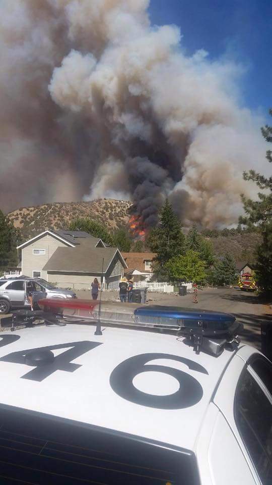
campingmom, Wed Aug 17 2016, 02:28PM
Hardware Store in Wrightwood. Not good. Shared same view a few minutes ago now much worse.
Re: BlueCut Fire 8-16-2016 (Cajon Pass)
SCM ALERT🚨, Wed Aug 17 2016, 02:31PM
Wow, that is scary!!!
Re: BlueCut Fire 8-16-2016 (Cajon Pass)
RvnNtheSnw, Wed Aug 17 2016, 03:27PM
Traffic on highway 138 in crestline is being directed by chp. The back up is pretty bad, but it is at least controlled. If you are a local and need to go down 18, I recommend going up to 18 via lake gregory drive and then taking the narrows down. Avoid top town if you can. Traffic at the turn off heading up is pretty bad. Take the narrows if you need to come into crestline and then come down lake gregory drive.
Re: BlueCut Fire 8-16-2016 (Cajon Pass)
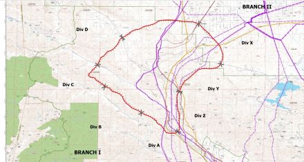
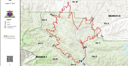
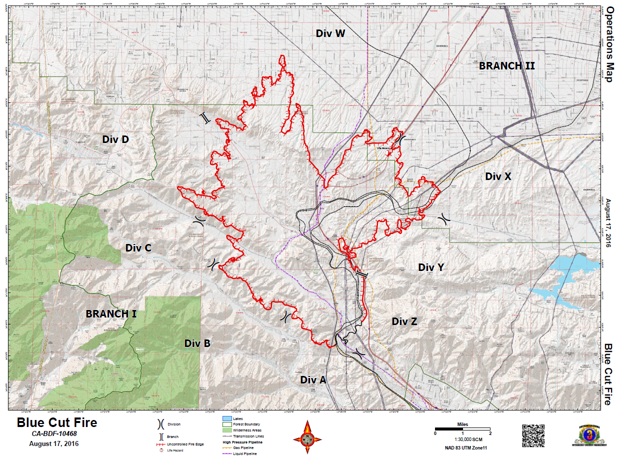
Benny ⭐, Wed Aug 17 2016, 05:08PM
Latest burn update & division map.
CLICK TO ENLARGE
Re: BlueCut Fire 8-16-2016 (Cajon Pass)
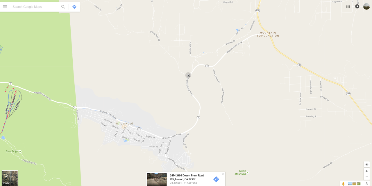
Craig ⭐, Wed Aug 17 2016, 05:20PM
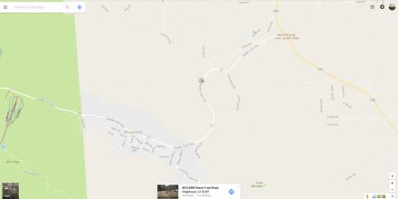
Per Scanner: Fire is crossing Hwy 2 at Desert Front north of Wrightwood.
See Map Below (click to enlarge)
Re: BlueCut Fire 8-16-2016 (Cajon Pass)
Benny ⭐, Wed Aug 17 2016, 05:24PM
Here's a little better map....
Re: BlueCut Fire 8-16-2016 (Cajon Pass)
BrownBear, Wed Aug 17 2016, 05:28PM
Pacific Crest area Wrightwood I have no info of what time

Re: BlueCut Fire 8-16-2016 (Cajon Pass)
DHRacer, Wed Aug 17 2016, 06:56PM
To add on to what RvnNtheSnw said, the 18 wasn't as bad today as yesterday going northbound from San Bernardino to Crestline. Southbound on the 18 this morning was decent as well.
I figure a lot of people stayed home today.
Can't tell you how it is in Crestline, I go past it on the 18, but I'd recommend the tip on going Lake Gregory Drive in and out of Crestline for residents there.
DHR
Re: BlueCut Fire 8-16-2016 (Cajon Pass)
booboo, Wed Aug 17 2016, 08:48PM
OK,from VOE or Crestline the 138 down is open.At the bridge with the temporary stoplight backup about 50 cars.From there you can go out 173 to the right,138 is blocked per family member
Re: BlueCut Fire 8-16-2016 (Cajon Pass)
booboo, Wed Aug 17 2016, 08:50PM
Re: BlueCut Fire 8-16-2016 (Cajon Pass)
Mtngoat John⭐, Wed Aug 17 2016, 09:45PM
New map up on Inciweb
[Click Here]
Re: BlueCut Fire 8-16-2016 (Cajon Pass)
SCM ALERT🚨, Wed Aug 17 2016, 10:11PM
PER MANY FOLKS HERE ON SCM AND ALSO CHP CAD:
NORTHBOUND INTERSTATE 15 WILL REOPEN SHORTLY. SOUTHBOUND INTERSTATE 15 WILL REMAIN CLOSED UNTIL FURTHER NOTICE. THANK YOU TO ALL FOR YOUR REPORTS AS WE MOVE THROUGH THIS INCIDENT.
Re: BlueCut Fire 8-16-2016 (Cajon Pass)
Lumber Jill, Thu Aug 18 2016, 08:35AM
Forest Service update:
Acreage increased to 31,689 Containment at 4% Northbound Interstate 15 opened at 10:15PM last night, southbound remains closed.
 blue_cut_fire_update_08_18_16_am.pdf
Re: BlueCut Fire 8-16-2016 (Cajon Pass)
Dragon, Thu Aug 18 2016, 08:45AM
MODIS data from 10:45pm and 3am:
Re: BlueCut Fire 8-16-2016 (Cajon Pass)
Dragon, Thu Aug 18 2016, 09:13AM
Water drop chopper with enhancement:
Re: BlueCut Fire 8-16-2016 (Cajon Pass)
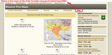
Dragon, Thu Aug 18 2016, 11:12AM
People were asking where to find maps on inciweb and I didn't even notice myself until Mtn goat John mentioned that they have a dedicated Maps link near the top right:
Re: BlueCut Fire 8-16-2016 (Cajon Pass)
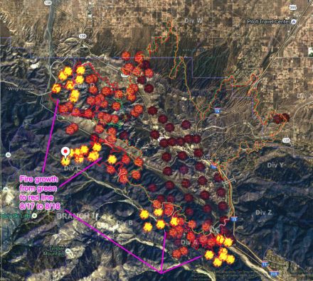
Dragon, Thu Aug 18 2016, 01:38PM
MODIS has a new fire perimeter so I combined it with the map from yesterday to show fire growth. No new MODIS data points have appeared yet today.
Re: BlueCut Fire 8-16-2016 (Cajon Pass)
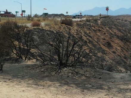
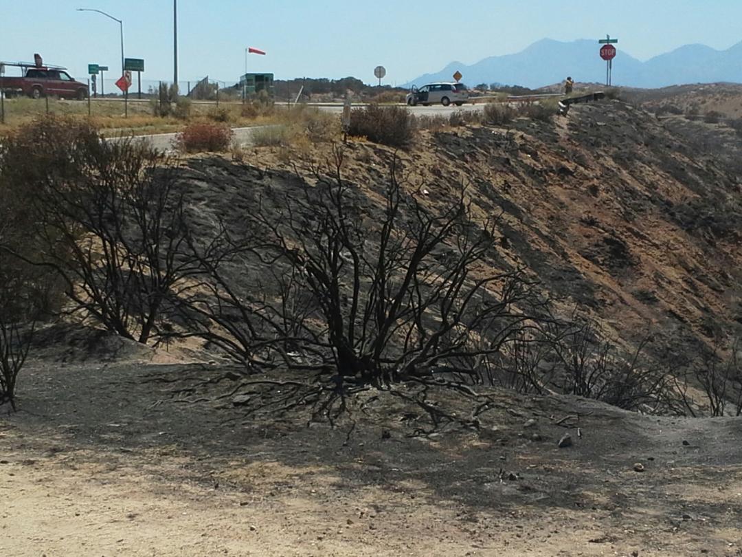
BrownBear, Thu Aug 18 2016, 02:00PM
Right now top of cajon pass west side...still smoldering. Oak Hills exit/onramp
Re: BlueCut Fire 8-16-2016 (Cajon Pass)
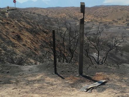
BrownBear, Thu Aug 18 2016, 02:02PM
Another shot more to the right/west of oak hill at the top
Re: BlueCut Fire 8-16-2016 (Cajon Pass)
Craig ⭐, Thu Aug 18 2016, 05:42PM
Thanks for the great pictures, maps, etc everyone! You all ROCK!!!! Dragon, when you were gone that one day, I was very depressed
Re: BlueCut Fire 8-16-2016 (Cajon Pass)
Dragon, Thu Aug 18 2016, 05:44PM
An 8 minute interview with the fire chief: [Click Here]
He reiterates that they haven't seen fires move like this before. Winds are up to 40mph through the Cajon pass. Humidity under 10 percent is not normal for August. It's as dry as during Santa Ana wind conditions, but without that dry wind from the north. Soil moisture is at "critical" levels. The plants "look green, but they burn like they're dead".
They can't put hand crews up in the hills because it's too dangerous, so they build thick lines of phos-chek instead. A lot of fighters were working on no sleep till yesterday when extra fire fighters got down from Northern California.
The chief cautioned that this is still considered to be early in the fire season and that it will get even dryer and warmer.
A viewer asked if this was the worst it's ever been. The chief said that's a subjective question but these are the worst conditions he's seen in his 25 years, and he's talked to 40-year veterans who work across the country and agree they've never seen anything like this in our area at this time of year.
The reporter mentioned the Cedar fire which killed 15 people and burned 3000 homes stands out as the worst in his memory. Chief agreed that one was bad and pointed out that we often refer back to the Old Fire and Grand Prix fires which met in Cajon pass in 2003, the same year as Cedar 100 miles to our south.
He ended with an explanation that the fire moves fastest when the wind direction blows it up slope and when the sun is at the worst angle to that slope (at a perpendicular angle, I assume). He pointed to a section of black smoke in the video as being "a very angry fire".
Re: BlueCut Fire 8-16-2016 (Cajon Pass)
campingmom, Thu Aug 18 2016, 07:29PM
And we haven't gotten to Oct and Santa Ana's yet. Kinds of worrisome for sure.
Re: BlueCut Fire 8-16-2016 (Cajon Pass)
Mtngoat John⭐, Thu Aug 18 2016, 10:06PM
Photo taken last night at 10:36pm.
Photo Courtesy NASA Earth Observatory
(click photo to enlarge)
Re: BlueCut Fire 8-16-2016 (Cajon Pass)
Craig ⭐, Thu Aug 18 2016, 10:32PM
Wow, incredible perspective there Mr Goat. Thank you so much for that. Now off to figure out all my bearings on that shot!
Re: BlueCut Fire 8-16-2016 (Cajon Pass)
Mtngoat John⭐, Fri Aug 19 2016, 06:38AM
Todays OP's Map showing uncontrolled lines and current containment lines
ops_arch_e_land_2016_blue_cut_cabdf00701_lr.pdf
Re: BlueCut Fire 8-16-2016 (Cajon Pass)
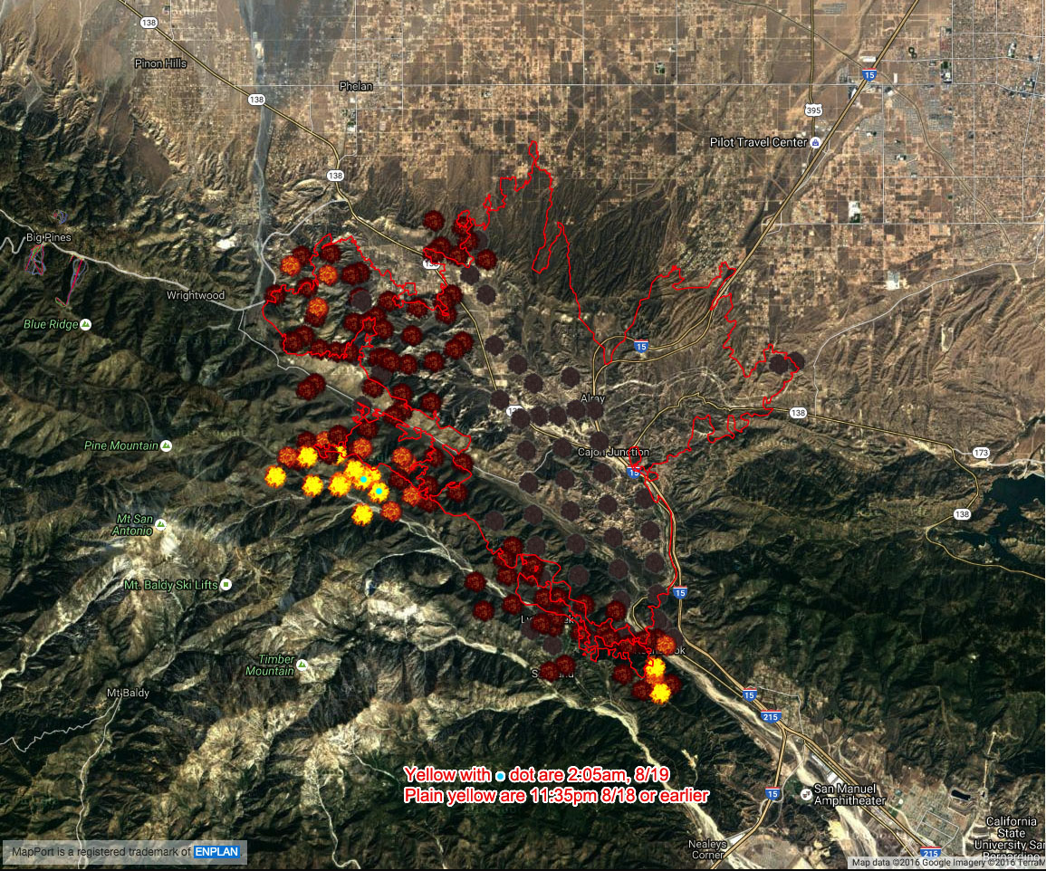
Dragon, Fri Aug 19 2016, 07:54AM
MODIS data from 2:05am:

Re: BlueCut Fire 8-16-2016 (Cajon Pass)
SCM ALERT🚨, Fri Aug 19 2016, 09:51AM
Thank you Mr. Dragon! You are the best!
Re: BlueCut Fire 8-16-2016 (Cajon Pass)
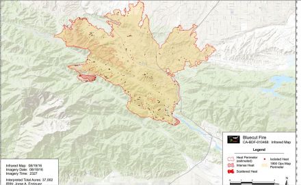
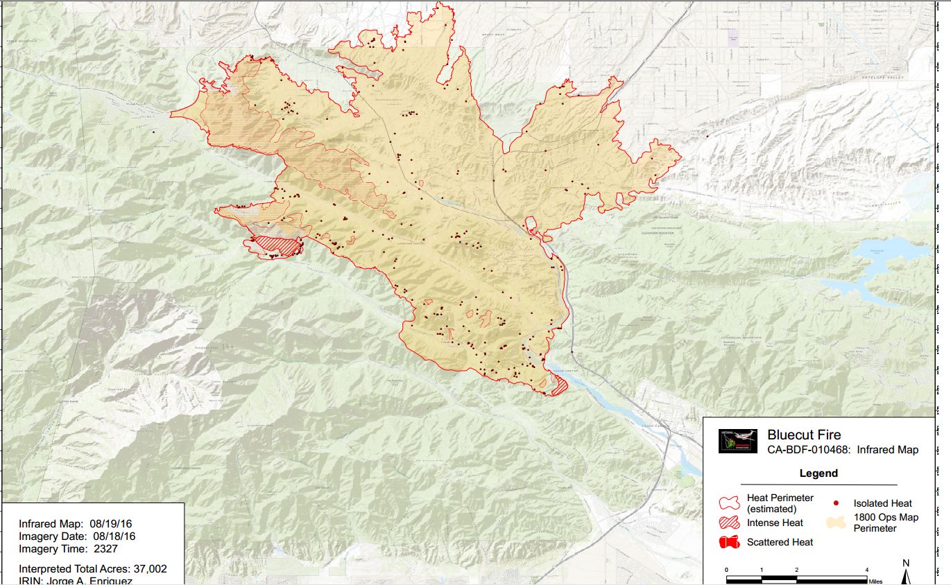
SCM ALERT🚨, Fri Aug 19 2016, 10:09AM
BlueCut IR and Perimeter map as of earlier this morning (Aug 8/19):
(click map to enlarge it)
Re: BlueCut Fire 8-16-2016 (Cajon Pass)
bills grandson, Fri Aug 19 2016, 10:53AM
That shot from space is hard to believe. but it appears to be a regular N S perspective The fire has traveled further East then what I understood. But if you look at it and the map posted just before this you can make sense of it. If that is possible. Most of the focus has been towards Wrightwood which is where the typical Cajon fires head Everything else is unusual. one branch goes towards the summit but the main fire goes up the valley toward Wrightwood. I don't recall one ever getting this far or spreading like it has. Those first couple hours was like nothing I have never seen. They need an very wide firebreak from the tracks to the West. Not seeing where it started these things often are caused by trains with hot brakes. I don't recall one burning in that section towards Baldy before that might be why it is so intense. Hopefuly they will get a handle on it soon
Re: BlueCut Fire 8-16-2016 (Cajon Pass)
Dragon, Fri Aug 19 2016, 08:53PM
MODIS data from 11:30am plus fire growth lines:
Notice the growth lines imply fire swept through Lytle Creek today, but the MODIS heat dots show that part of the spread actually happened yesterday. There was only one big source of heat left at 11am today as marked by the blue dot.
Re: BlueCut Fire 8-16-2016 (Cajon Pass)
Lumber Jill, Sat Aug 20 2016, 06:30AM
News Release - Blue Cut Fire - INCIDENT COMMANDERS ASK FOR PUBLIC’S HELP
FOR IMMEDIATE RELEASE
Friday, August 19, 2016 9:00 p.m.
On Scene Media Contact Information: (909) 473-0774
Fire Information Line: (909) 383-5688
The Blue Cut Fire remains under investigation, however, the Unified Incident Commanders have determined that the public’s assistance is needed.
Anyone who may have been in or around the area of southbound Interstate 15 between Cleghorn and Kenwood Roads or along Old Cajon Boulevard through this same section on Tuesday, August 16th, between 10:00 am and 11:00 am and believe that they may have seen something suspicious is asked to share that information.
If you believe you have information, photos, or video of this area in this time frame, please call 1-800-78-CRIME (27463) or on the web at [Click Here]
The Blue Cut Fire started on Tuesday, August 16th, and has so far burned 37,020 acres, destroyed 105 homes, 216 outbuildings and is at 40% containment.
All calls can remain confidential. Thank you for your assistance in this ongoing investigation.
John Miller
Public Affairs Officer
Forest Service
San Bernardino National Forest
p: 909-382-2788
f: 909-383-5770
jmiller02©fs.fed.us
602 South Tippecanoe Avenue
San Bernardino, CA 92408
[Click Here]
[Click Here]
Re: BlueCut Fire 8-16-2016 (Cajon Pass)
Lumber Jill, Sat Aug 20 2016, 06:33AM
Forest Service updatefrom last night:
Highlights:
Acreage rises to 37,020 and containment jumps to 40%.
Evacuation areas reduced, and State Highway 138 re-opens east of Interstate 15
blue_cut_fire_update_20160819_pm.pdf
Re: BlueCut Fire 8-16-2016 (Cajon Pass)
Lumber Jill, Sat Aug 20 2016, 10:11AM
Forest Service morning update:
Highlights: Acreage remains unchanged, containment rises to 68% as firefighters work around the clock to fully contain the fire.
blue_cut_fire_update_20160820_am.pdf
Re: BlueCut Fire 8-16-2016 (Cajon Pass)
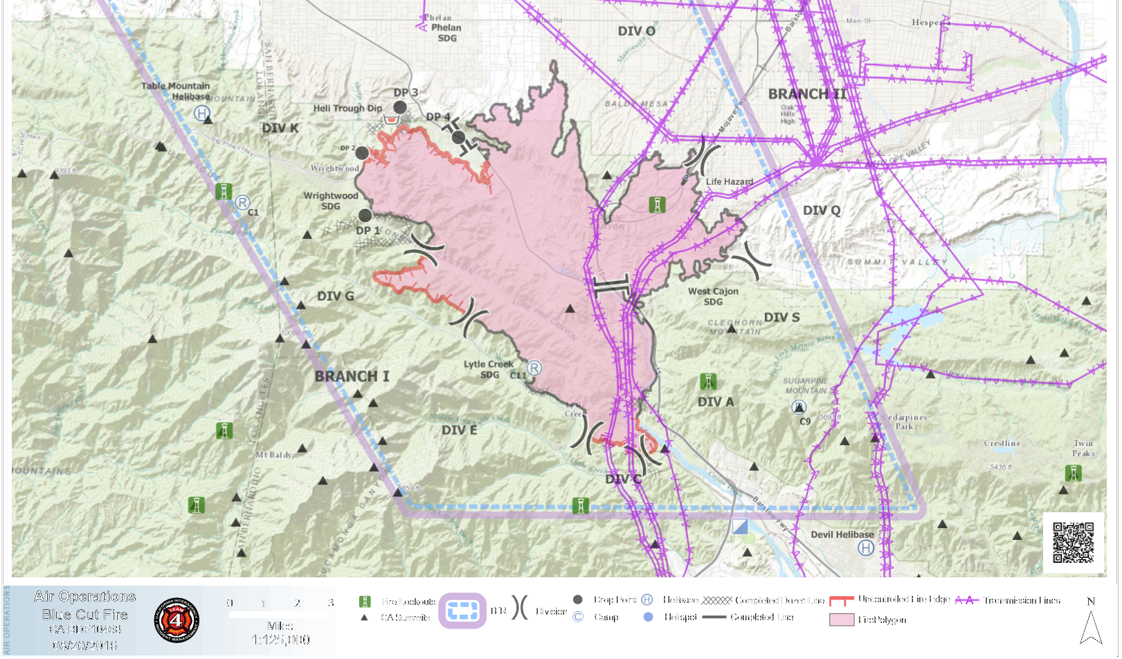
Craig ⭐, Sat Aug 20 2016, 11:45AM
SAT AUGUST 20 AIR OPERATIONS MAP
(Click Map to Enlarge)
Re: BlueCut Fire 8-16-2016 (Cajon Pass)
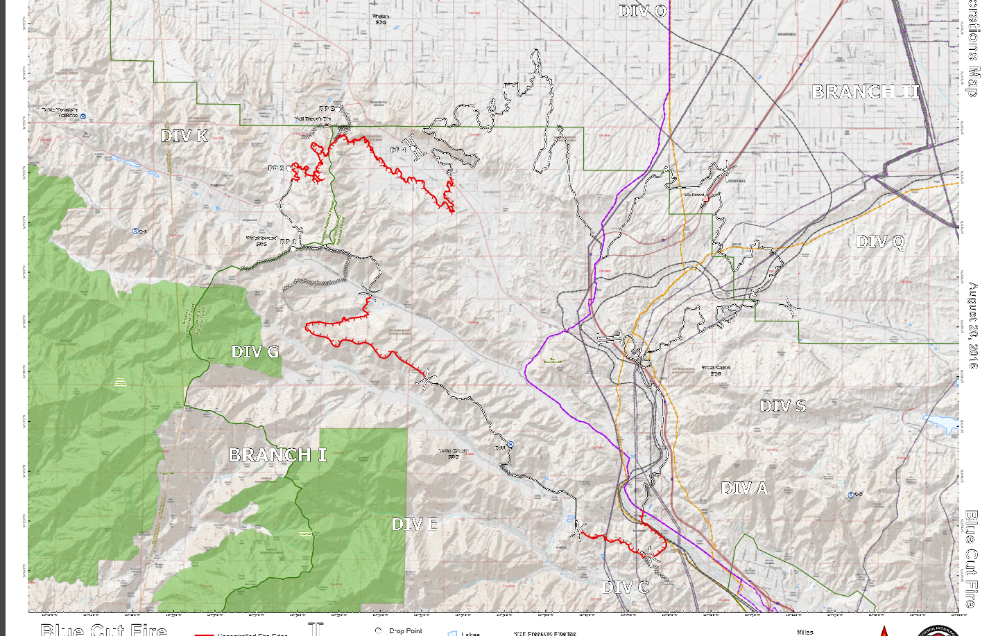
Craig ⭐, Sat Aug 20 2016, 11:46AM
SAT AUGUST 20 CONTAINMENT MAP
(click map to enlarge)
Re: BlueCut Fire 8-16-2016 (Cajon Pass)
Craig ⭐, Sat Aug 20 2016, 11:47AM
PER SBNF TWITTER: MANDATORY EVACS FOR WRIGHTWOOD WILL BE REDUCED TO VOLUNTARY AT 12 NOON. RESIDENTS ONLY. ID REQUIRED
Re: BlueCut Fire 8-16-2016 (Cajon Pass)
Lumber Jill, Sat Aug 20 2016, 09:54PM
Forest Service update:
Highlights: Containment jumps to 73%, residents return to Wrightwood.
Re: BlueCut Fire 8-16-2016 (Cajon Pass)
Lumber Jill, Sat Aug 20 2016, 09:59PM
Sorry...my phone doesn't want to upload the update :/
Re: BlueCut Fire 8-16-2016 (Cajon Pass)
Benny ⭐, Sat Aug 20 2016, 09:59PM
Gotcha covered!
Update August 20th, 2016, 7:00 p.m.
Location: Devore, California
Date and Time of Fire Start: August 16, 2016, 10:44 a.m.
Cause: Under Investigation
Size: 37,020 acres Containment: 73 percent
Management: California Interagency Incident Management Team 4
Cooperating Agencies: BNSF Railway, Union Pacific Railway, Cal Trans, Southern California Edison, LA DWP, American Red Cross, San Bernardino Animal Control, California Department of Corrections and Rehabilitation and the California Highway Patrol
Fire Status: Firefighters continued to extinguish hot spots within fire lines. The work of firefighters and utility crews enabled the lifting of the mandatory evacuation of Wrightwood which is now open to residents. Tonight firefighters will continue to work aggressively to complete containment lines and reinforce existing lines. Utility companies will continue work to replace damaged or destroyed infrastructure. The fire has destroyed 105 single family homes and 213 other minor structures. For information on damaged or destroyed homes please contact the Local Assistance Center at 760-539-3093 between 8:00 a.m. and 5:00 p.m.
Resources:
Hand Crews: 46 Engines: 177 Dozers: 29 Water Tenders: 25 Helicopters: 9
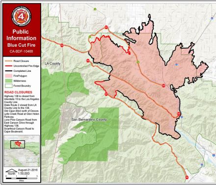
Closure Update as of 7:00 p.m.:
• Highway 138 is closed between Beekley Rd and Interstate 15
• State Route 2 is closed from LA County line to the 138
• Old Cajon Blvd. north of Devore
• Lytle Creek Rd. at Glen Helen Parkway
• Lone Pine Canyon Rd. from East Canyon Drive through Highway 138
• Swarthout Canyon Road to Cajon Boulevard
Mandatory Evacuation:
Community of Lytle Creek and West Cajon Valley
Voluntary Evacuation:
• The community of Wrightwood is open to residents with proof of address
Evacuation Centers:
Jessie Turner Community Center San Bernardino County Fairgrounds
15556 Summit Avenue 14800 Seventh St.
Fontana, CA Victorville, CA
Further Information: Information Call Center (909) 383-5688 or
[Click Here]
Re: BlueCut Fire 8-16-2016 (Cajon Pass)
Lumber Jill, Sun Aug 21 2016, 06:55AM
Thanks Beanie!
Re: BlueCut Fire 8-16-2016 (Cajon Pass)
Mtngoat John⭐, Sun Aug 21 2016, 08:33AM
Current map showing containment lines
(click image to enlarge)
Re: BlueCut Fire 8-16-2016 (Cajon Pass)
Mtngoat John⭐, Tue Aug 23 2016, 08:36PM
Pretty incredible set of photos put together by the SB Sun. 150 or so of them.
[Click Here]
Re: BlueCut Fire 8-16-2016 (Cajon Pass)
Cornbread, Wed Aug 24 2016, 10:37AM
Great pic's but sad too
Re: BlueCut Fire 8-16-2016 (Cajon Pass)
©ammy, Wed Aug 24 2016, 09:36PM
This one is amazing!
Re: BlueCut Fire 8-16-2016 (Cajon Pass)
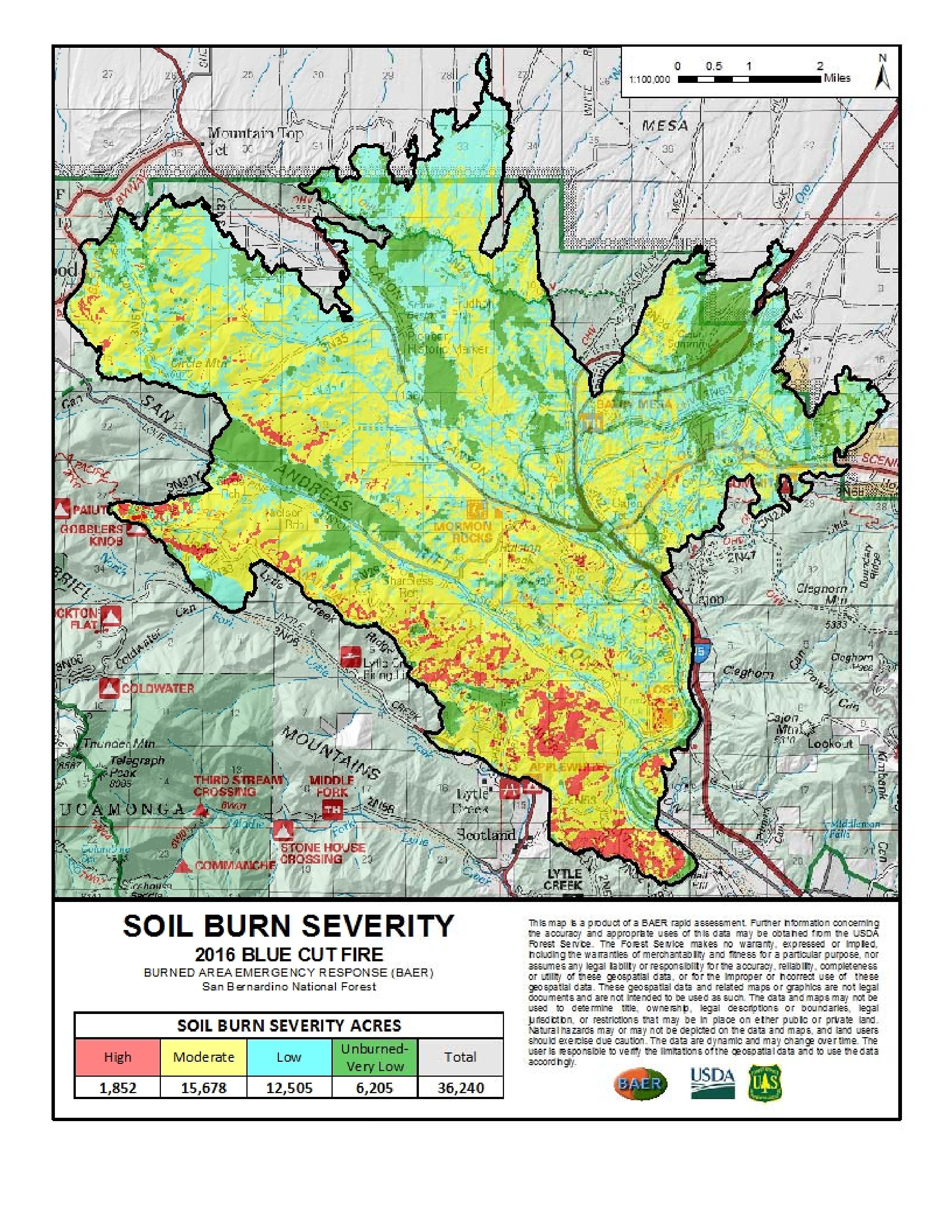
Lumber Jill, Fri Sep 02 2016, 11:07AM
Blue Cut Update
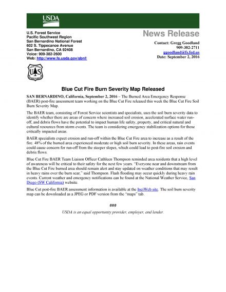
Re: BlueCut Fire 8-16-2016 (Cajon Pass)
Lumber Jill, Fri Sep 02 2016, 04:07PM
Forest Service Closes Blue Cut Fire Area to Public Use
SAN BERNARDINO, California, September 2, 2016 – To address public safety concerns, the San Bernardino National Forest issued today an Area Closure for the Blue Cut Fire effective Saturday, September 3, 2016.
The area closure is intended to keep the public safe from post-fire hazards such as falling snags, rolling debris and water run-off. Simply being in the area where these types of hazards exist possess a significant risk to the public.
“Wildfires on our public lands often leave fragile and very unsafe conditions on the landscape that can be dangerous to forest visitors,” said Elrand Denson, Deputy Forest Supervisor of the San Bernardino National Forest. “To ensure the public’s safety, a large area of forest that was affected by the Blue Cut Fire has been closed to all public use.”
The Blue Cut Fire area closure specifically prohibits:
· Going into or being upon National Forest System lands within the Blue Cut Fire Closure Area
· Being on any National Forest System trail within the Blue Cut Fire Closure Area, except for the Pacific Crest Trail
· Being on any National Forest System road within the Blue Cut Fire Closure Area
The areas subject to the closure are commonly referred to as the following:
· Upper Lytle Creek Divide Area
· Stockton Flats Area
· Baldy Mesa OHV Staging/Area
· Lost Lake Area
· Applewhite Campground
· Applewhite Truck Trail
· Sheep Canyon Area
· Cajon Wash Area
· Cajon Pass
Forest users are encouraged to contact the Mill Creek Visitor Center at 909 382 2882, prior to visiting the forest if they have specific questions on which roads and trails are closed.
The full text of the order and maps can be found on the San Bernardino National Forest website.
Gregg Goodland
Deputy Public Affairs Officer - Acting
Forest Service
San Bernardino National Forest
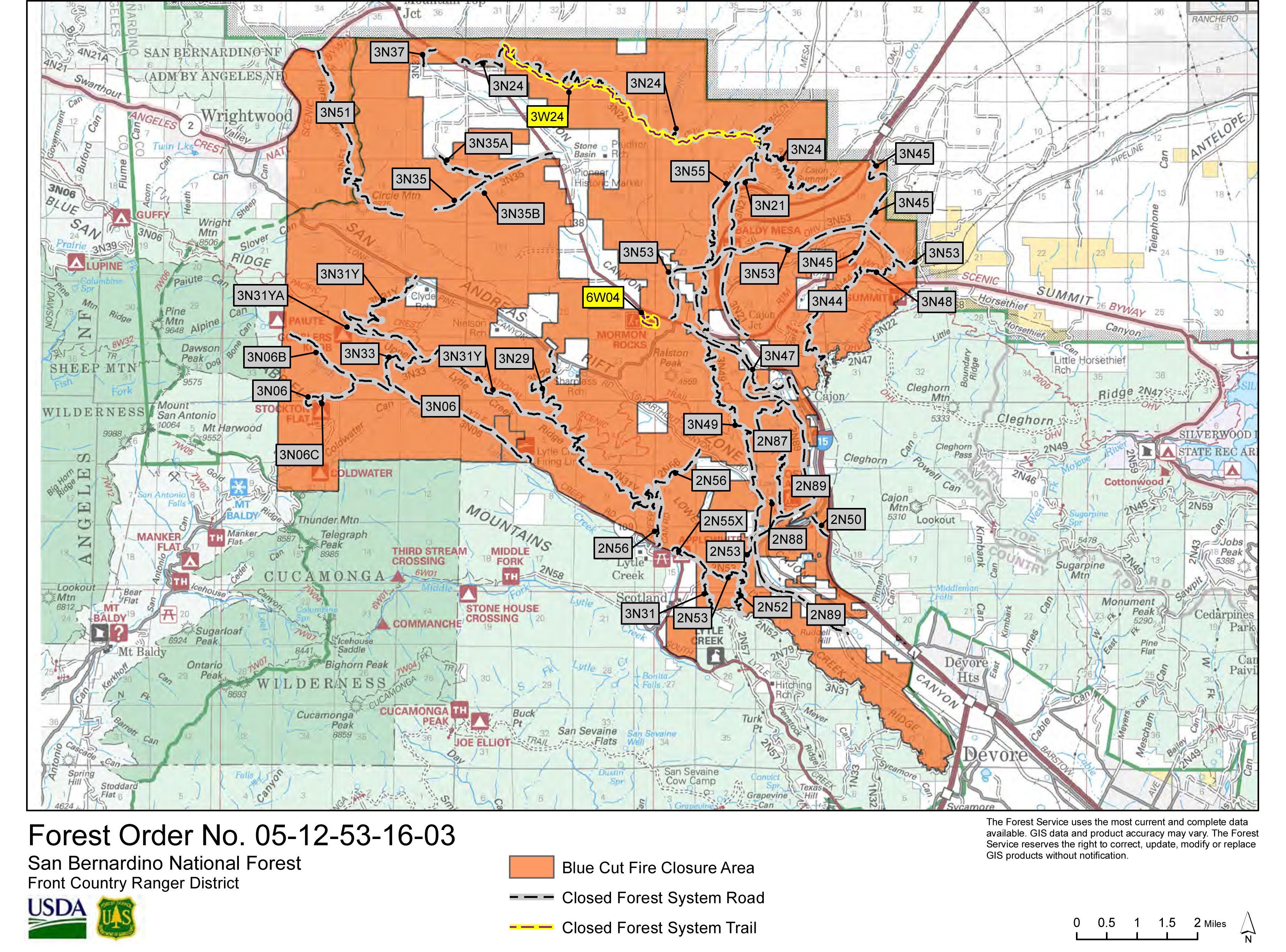
Re: BlueCut Fire 8-16-2016 (Cajon Pass)
©ammy, Sat Sep 03 2016, 09:09PM
Map of the Blue Cut Fire closure area:
(click on image to enlarge)
Re: BlueCut Fire 8-16-2016 (Cajon Pass)
©ammy, Sat Sep 03 2016, 09:09PM
You've likely seen pictures of a fire camp before, but here's what I'm calling Edison camp: [Click Here]
SCM ALERT🚨, Tue Aug 16 2016, 12:15PM
FIRE STARTED: TUE AUG 16, 2016, 10:55 AM
NOW AT OVER 1000 ACRES MOVING UP LONE PINE CANYON - LIFE AND PROPERTY THREAT
EVACUATIONS: All Areas south of Hwy 2 (Lone Pine Canyon and Swarthout Canyon)
Re: BlueCut Fire 8-16-2016 (Cajon Pass)
SCM ALERT🚨, Tue Aug 16 2016, 12:20PM
Here's the live shot from the #ktla camera located at Snow Summit, updated every 10 minutes... [Click Here]

Re: BlueCut Fire 8-16-2016 (Cajon Pass)
SCM ALERT🚨, Tue Aug 16 2016, 12:21PM
Another photo from a traveler going through Cajon, couresty wrightwoodcalif.com [Click Here]

Re: BlueCut Fire 8-16-2016 (Cajon Pass)
BrownBear, Tue Aug 16 2016, 12:55PM
Getting tired of posting this kind of view from Hesperia! God bless our firemen and all the authorities involved

Re: BlueCut Fire 8-16-2016 (Cajon Pass)
SCM ALERT🚨, Tue Aug 16 2016, 01:01PM
Mandatory Evacuations In Place for:
All area south of Wrightwood all the way to I15 and all canyons in that area.
NEW Mandatory Evac: Lytle Creek - GET OUT NOW
Re: BlueCut Fire 8-16-2016 (Cajon Pass)
SCM ALERT🚨, Tue Aug 16 2016, 02:29PM
Per Wrightwoodcalif.com
Via Facebook:
Snowline Joint Unified School District
23 mins ·
You may be aware that a fire recently started near the I-15 that is currently impacting our district. At this point, the actions we are taking to secure the safety of students and adults are as follows:
Wrightwood ES students are being sent home due to mandatory evacuations in West Cajon Valley and voluntary evacuations in Wrightwood. As of right now, students who are not picked up by 3:45 PM will be transported to Serrano High School.
Students who live in Wrightwood or West Cajon Valley and attend Serrano HS, Chaparral HS, Eagle Summit CDS, Pinon Mesa MS, and Pinon Hills ES will be sent to the Serrano HS gymnasium for parent pickup due to the road closures preventing buses from transporting such students.
All other schools will continue to operate as normal and their students will be transported as usual.
This is rapidly developing situation, so please stay tuned for updates to ensure that the safety of all can be maintain. Your help and support is greatly appreciated.
Thank you,
Ryan Holman
Re: BlueCut Fire 8-16-2016 (Cajon Pass)
SCM ALERT🚨, Tue Aug 16 2016, 03:01PM
ACREAGE 5500
TUE AUG 16, 2016, 10:55 AM (UPDATED: 2:52 PM)
VEGETATION FIRE
CAJON PASS, CAJON PASS
2ND ALARM VEGETATION FIRE INTERSTATE 15 NEAR CLEGHORN (OLD CAJON)ML12
INCIDENT NAME: BLUECUT
LIVE WEBCAM (FROM BIG BEAR): [Click Here]
MANDATORY EVACUATIONS:
Lone Pine Canyon
Swarthouth Canyon
Lytle Creek
Hwy 138 WEST of I15 North to Phelan Road
Ranchero Rd to Summit Valley EAST of I15
VOLUNTARY EVACS:
Town of Wrightwood
LARGE ANIMAL EVACUATIONS: VICTORVILLE FAIRGROUNDS
READY! SET! GO! CLICK HERE: [Click Here]
NOTE: US FOREST SERVICE HAS BEEN REQUESTED TO RESPOND TO THIS INCIDENT
NOTE: CALFIRE HAS BEEN REQUESTED TO RESPOND TO THIS INCIDENT
UNITS RESPONDING: BC121 I165 BE226 BE228 ME225 BE75 ME241 GLEN HELEN CREW15-2 GLEN HELEN CREW15-3 FEDCOM (FOREST SERVICE) SUP15 BC912 BC125 WT77 WT175 BE23 BE9 ME22 FEDCOM (FOREST SERVICE) CALCOM (CALFIRE) (SAN BERNARDINO NATIONAL FOREST SERVICE )
CLICK HERE FOR DETAILS EDIT
Re: BlueCut Fire 8-16-2016 (Cajon Pass)
SCM ALERT🚨, Tue Aug 16 2016, 03:09PM
We have our SCM photographer in the field and will be posting additional photos as they come to us... Courtesy Member: (Cy)FirePhoto84 - @EPN105

Re: BlueCut Fire 8-16-2016 (Cajon Pass)
SCM ALERT🚨, Tue Aug 16 2016, 03:19PM
#BlueCutFire - Mandatory evacuations for the community of Baldy Mesa north of Phelan Road.

Re: BlueCut Fire 8-16-2016 (Cajon Pass)
SCM ALERT🚨, Tue Aug 16 2016, 03:25PM
EVACUATIONS HAVE GONE TO MANDATORY FOR THE ENTIRE COMMUNITY OF WRIGHTWOOD!
EVERYONE should be reviewing this SB County Fire Document no matter if you are in danger, could be in danger, or don't think you will ever be in danger. Ready, Set, GO! [Click Here]
Re: BlueCut Fire 8-16-2016 (Cajon Pass)
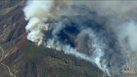
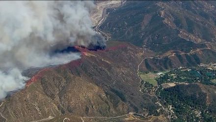
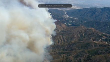
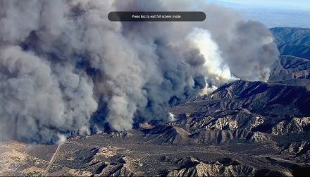
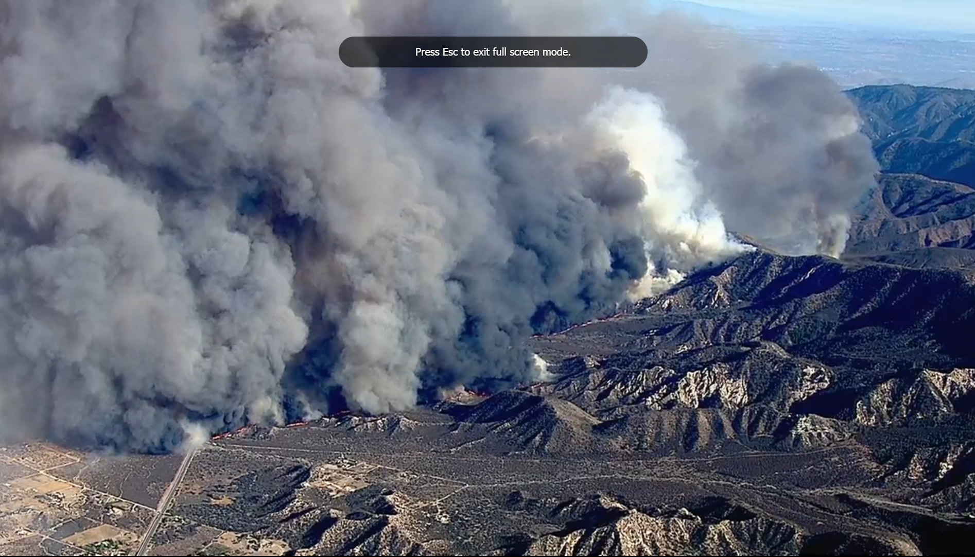
Dragon, Tue Aug 16 2016, 03:44PM
Various pics from the ABC chopper [Click Here] taken between 3 and 3:15pm:


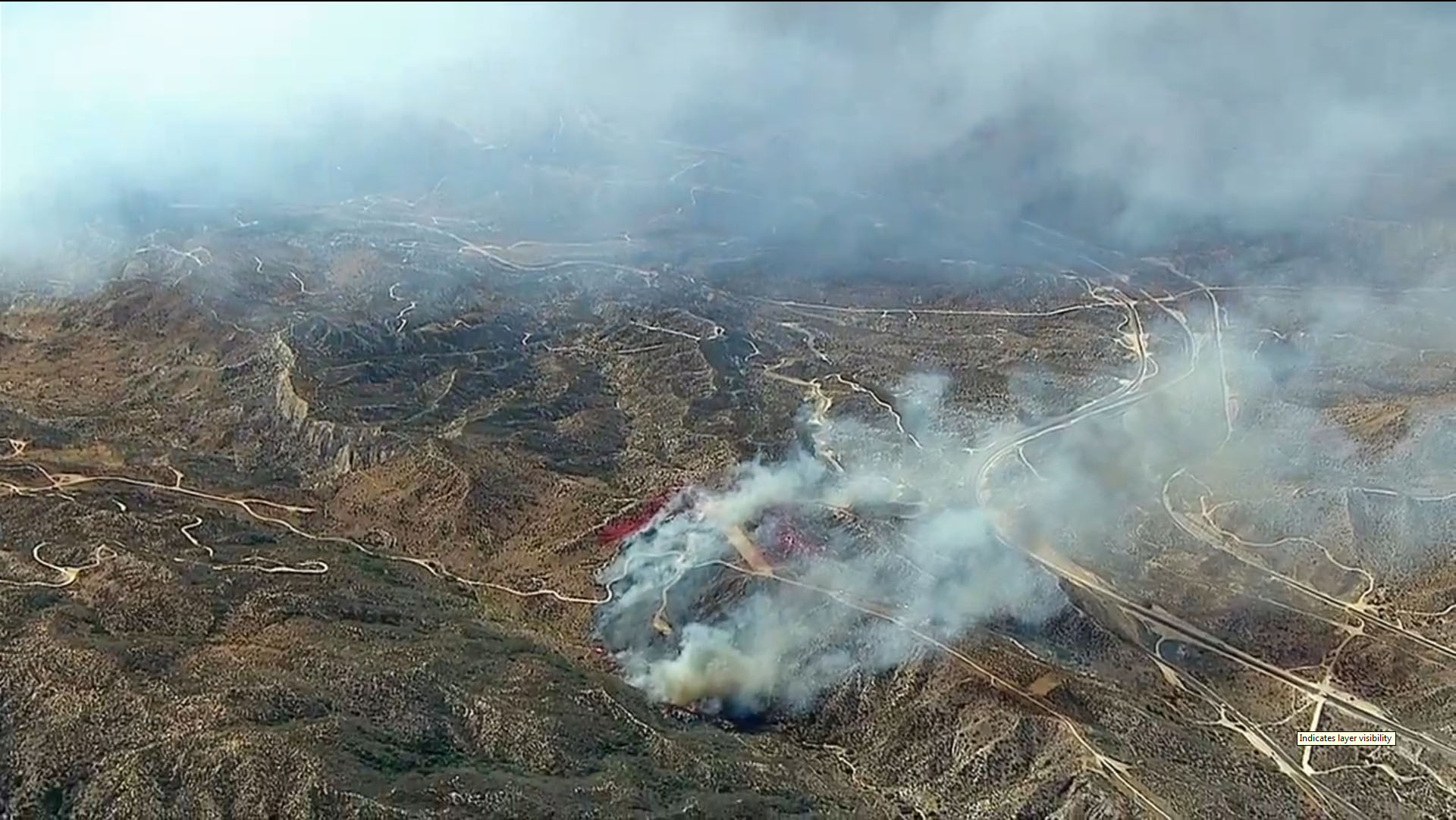
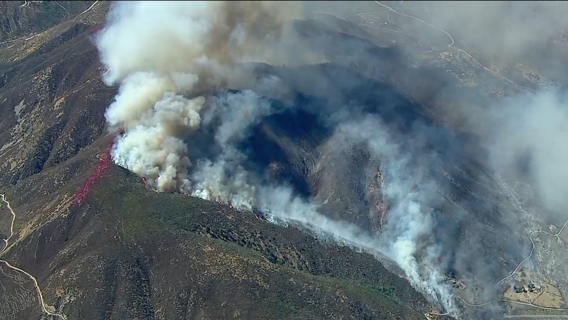
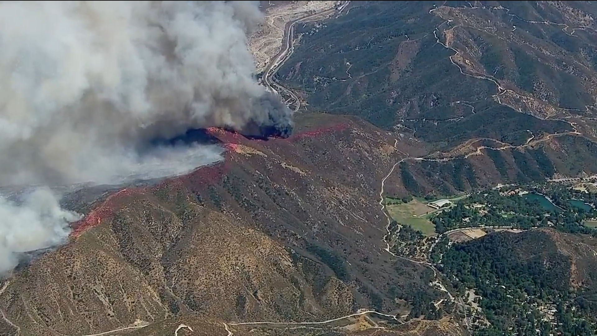
This one has grown quickly to a gigantic scale and I've seen structures already reduced to ash in one part of the video (didn't get a screenshot of it unfortunately). High winds were dispersing fire retardant till it seemed to disappear behind the flames instead of landing ahead of the flames. It looks like winds may have calmed in the current video (3:45).
Re: BlueCut Fire 8-16-2016 (Cajon Pass)
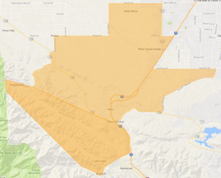
SCM ALERT🚨, Tue Aug 16 2016, 04:48PM
Evacuation Area Map thanks to SCPR.org (full link to map below)
[Click Here]
(click to enlarge)
Re: BlueCut Fire 8-16-2016 (Cajon Pass)
SCM ALERT🚨, Tue Aug 16 2016, 04:55PM
Firefighters Entrapped By Raging Wildfire
Initial Date/Time: August 16, 2016, 10:36 a.m.
Location: Swarthout Canyon, Cajon Pass
Incident: Blue Cut Fire
Cajon Pass, CA – Six firefighters became entrapped by wildfire today while defending homes and assisting evacuations in the Swarthout Canyon area west of Cajon Pass. The six firefighters were part of two San Bernardino County Fire (SBCoFD) engine companies assigned to the area northwest of Cajon Blvd.
Firefighters were able to shelter in place within a nearby structure, but two firefighters sustained minor injuries. Both firefighters were transported to a local hospital where they were treated and released and are now back on the fire line defending structures. One SBCoFD fire engine sustained moderate fire damage.
SBCoFD reminds residents to be prepared and know your evacuation routes. An evacuation order can save your life, leave as soon as evacuations orders are given by fire and law enforcement officials to avoid being caught in fire, smoke or road congestion. Residents that refuse to evacuate put their own and other people’s lives at risk.
Visit sbcfire.org/ReadySetGo.aspx for fire preparedness and safety information. For more information on the Blue Cut Fire, call 909-383-5688 or visit [Click Here]
Re: BlueCut Fire 8-16-2016 (Cajon Pass)
SCM ALERT🚨, Tue Aug 16 2016, 04:58PM
PER SBNF: RESOURCES ON THE FIRE INCLUDE 102 ENGINES, 15 CREWS (OF 30 FIREFIGHTERS EACH), 8 HELICOPTERS, 8 AIR TANKERS, AND 2 VLATS (VERY LARGE AIR TANKERS) - 750 PERSONNEL ON SCENE AT THIS TIME WITH MANY MORE RESOURCES ON THE WAY
Re: BlueCut Fire 8-16-2016 (Cajon Pass)
Dragon, Tue Aug 16 2016, 05:12PM
Burn and evac area map from sbsun.com. This looks like the fire area from like 1 or 2pm. I think it's crossed 138 and the 15 to the north by now.
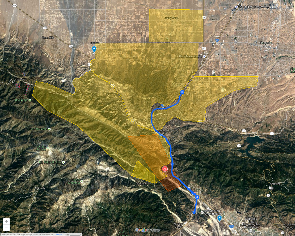
Re: BlueCut Fire 8-16-2016 (Cajon Pass)
SCM ALERT🚨, Tue Aug 16 2016, 05:30PM
Dragon wrote ...
Burn and evac area map from sbsun.com. This looks like the fire area from like 1 or 2pm. I think it's crossed 138 and the 15 to the north by now.
Burn and evac area map from sbsun.com. This looks like the fire area from like 1 or 2pm. I think it's crossed 138 and the 15 to the north by now.
Duplicate post, it's posted 2 above yours...
Re: BlueCut Fire 8-16-2016 (Cajon Pass)
Dragon, Tue Aug 16 2016, 05:42PM
Pics from 5:30pm. The second is panned left of the first. I don't know what road that is or what location this was taken from:
Re: BlueCut Fire 8-16-2016 (Cajon Pass)
Dragon, Tue Aug 16 2016, 05:44PM
***SCM ALERT*** wrote ...
Duplicate post, it's posted 2 above yours...
Duplicate post, it's posted 2 above yours...
Previous post doesn't include the burn area as far as I can tell.
Re: BlueCut Fire 8-16-2016 (Cajon Pass)
SCM ALERT🚨, Tue Aug 16 2016, 05:48PM
Dragon wrote ...
Previous post doesn't include the burn area as far as I can tell.
***SCM ALERT*** wrote ...
Duplicate post, it's posted 2 above yours...
Duplicate post, it's posted 2 above yours...
Previous post doesn't include the burn area as far as I can tell.
True but that's off as well, the fire's near doubled the size of your post.
Re: BlueCut Fire 8-16-2016 (Cajon Pass)
Dragon, Tue Aug 16 2016, 05:49PM
Chopper moved to a different vantage point. First pic is panned left, second is panned right. 5:45pm:

Re: BlueCut Fire 8-16-2016 (Cajon Pass)
chekkasan, Tue Aug 16 2016, 05:51PM
Chekkasan checking in:
Traffic the back way is bumper to bumper, but moving both ways!
Re: BlueCut Fire 8-16-2016 (Cajon Pass)
SCM ALERT🚨, Tue Aug 16 2016, 05:52PM
Chekka, what's your location?
Re: BlueCut Fire 8-16-2016 (Cajon Pass)
Cap'n Crunch, Tue Aug 16 2016, 06:11PM
Just a guess but the first picture looks like it might have been taken from above Phelan looking SE. If so, the larger road on the left could be a portion of HWY 138?
Re: BlueCut Fire 8-16-2016 (Cajon Pass)
bills grandson, Tue Aug 16 2016, 06:16PM
It might just be me but when I look at them it looks like the smoke is moving
Re: BlueCut Fire 8-16-2016 (Cajon Pass)
SCM ALERT🚨, Tue Aug 16 2016, 06:34PM
Quick Flash Report update @ 6:30pm:
#BlueCutFire in Cajon Pass (San Bernardino Co) is 9000 acres, 0% contained, 82,000 residents under mandatory evac.
Re: BlueCut Fire 8-16-2016 (Cajon Pass)
SCM ALERT🚨, Tue Aug 16 2016, 06:49PM
The header and plume from this fire has made it all the way up to 20,000-30,000 feet. At times a pyrocumulus.
Radar Link [Click Here]
And of course it's very visible on the visible satellite loop, reaching all the way out to Las Vegas... [Click Here]
Re: BlueCut Fire 8-16-2016 (Cajon Pass)
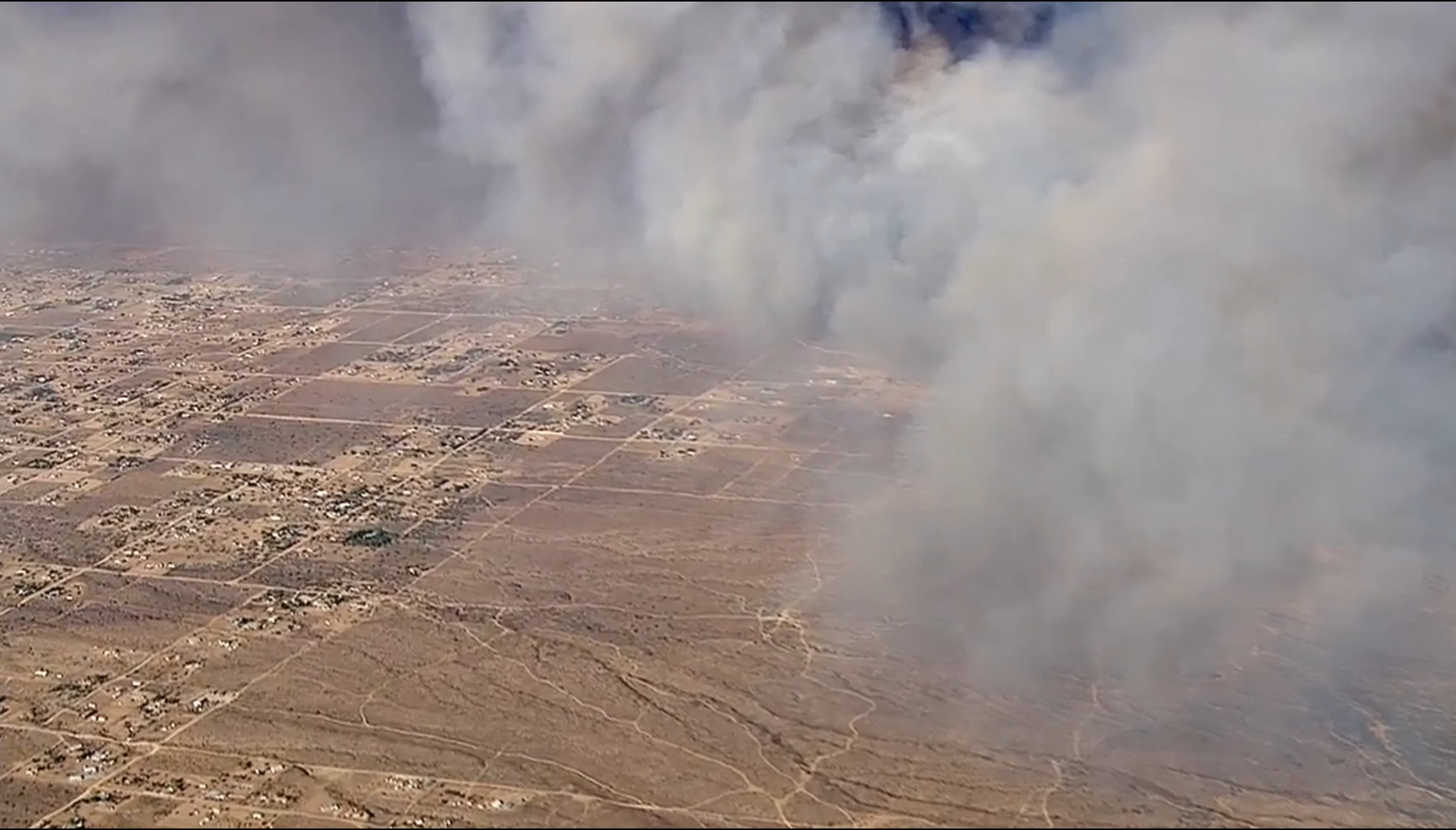
Dragon, Tue Aug 16 2016, 06:59PM
Looking northwest from just S of Cajon Junction (around 34.310723, -117.473607). I-15 goes up right, 138 goes up left. McDonalds being threatened is just off camera in the lower right corner.

Re: BlueCut Fire 8-16-2016 (Cajon Pass)
SCM ALERT🚨, Tue Aug 16 2016, 07:07PM
The McDonalds actually did catch fire, but I didn't hear if they saved it or not. Photo from KTLA...
Re: BlueCut Fire 8-16-2016 (Cajon Pass)
Dragon, Tue Aug 16 2016, 07:10PM
Cap'n Crunch wrote ...
Just a guess but the first picture looks like it might have been taken from above Phelan looking SE. If so, the larger road on the left could be a portion of HWY 138?
Just a guess but the first picture looks like it might have been taken from above Phelan looking SE. If so, the larger road on the left could be a portion of HWY 138?
I've been trying to use Google Earth to match some of the images but no luck so far. In the two pics before the Cajon Junction pics they swung the camera 180 and I thought I saw Silverwood Lake, which puts them between silverwood and 15, but I couldn't match it to Google Earth.
Re: BlueCut Fire 8-16-2016 (Cajon Pass)
Dragon, Tue Aug 16 2016, 07:29PM
Here's two more I really wish I could match on Google Earth because the terrain looks like Crestline area (where I am). I suspect it's on the Wrightwood side but can't match it. The second image is panned a bit up and right from the first and the terrain is much darker (underexposed).
Re: BlueCut Fire 8-16-2016 (Cajon Pass)
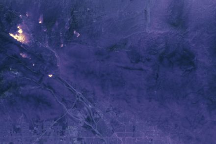
Dragon, Tue Aug 16 2016, 07:56PM
MODIS hot spots, 2:15pm:
Re: BlueCut Fire 8-16-2016 (Cajon Pass)
robk (K6RBK), Tue Aug 16 2016, 08:02PM
Dragon wrote ...
Here's two more I really wish I could match on Google Earth because the terrain looks like Crestline area (where I am). I suspect it's on the Wrightwood side but can't match it. The second image is panned a bit up and right from the first and the terrain is much darker (underexposed).
Here's two more I really wish I could match on Google Earth because the terrain looks like Crestline area (where I am). I suspect it's on the Wrightwood side but can't match it. The second image is panned a bit up and right from the first and the terrain is much darker (underexposed).
That top photo appears to be looking SE at a point just NE of the intersection of Macapa Road and Stone Basin Road, approximately 34° 21.154'N by 117° 32.788'W.
Looks like Stone Basin road running through the lower part of the photo, and also making that 90 degree turn in the lower left of the photo.
Rob
Re: BlueCut Fire 8-16-2016 (Cajon Pass)
⚡WX ALERT⚡, Tue Aug 16 2016, 08:06PM
Here's a picture at sunset from the Baldy Mesa area...

Re: BlueCut Fire 8-16-2016 (Cajon Pass)
BrownBear, Tue Aug 16 2016, 08:25PM
It hurts to see this. Someone posted this to facebook

Re: BlueCut Fire 8-16-2016 (Cajon Pass)
⚡WX ALERT⚡, Tue Aug 16 2016, 08:33PM
8:30pm Flash Report per Calfire PIO
#BlueCutFire in the Cajon Pass (San Bernardino County) is now 15,000 acres, 0% contained. 15 & 138 remain closed.
Photo: @crimeshutterbug

Re: BlueCut Fire 8-16-2016 (Cajon Pass)
DHRacer, Tue Aug 16 2016, 08:35PM
Just FYI for mountain residents. 18 north to Crestline is jacked up. Go 330, much better then backtrack west on the 18 to communities like Twin Peaks, Crestline, etc. I was almost going to go 38 into Big Bear if both 18 and 330 were a mess but only the 18 was.
DHR
Re: BlueCut Fire 8-16-2016 (Cajon Pass)
SCM ALERT🚨, Tue Aug 16 2016, 08:54PM
Thank you DHRacer!
Re: BlueCut Fire 8-16-2016 (Cajon Pass)
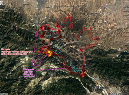
Dragon, Tue Aug 16 2016, 09:02PM
robk (K6RBK) wrote ...
That top photo appears to be looking SE at a point just NE of the intersection of Macapa Road and Stone Basin Road, approximately 34° 21.154'N by 117° 32.788'W.
Looks like Stone Basin road running through the lower part of the photo, and also making that 90 degree turn in the lower left of the photo.
Rob
Wow, you're totally right! I couldn't find it because the sun in Google maps makes that distinctive rock pattern look very different, but all the roads line up perfectly. So I used Google Earth to click points that match the fire line in the photo to trace this approximate western edge of the fire as of 7pm:
Fire edge is the red line and I overlaid it on the image of the evac area with the old fire border for comparison. Hopefully the low winds will let them get a line around it... but bad terrain and no roads or aircraft makes that seem a little hopeless... =(
Re: BlueCut Fire 8-16-2016 (Cajon Pass)
Cap'n Crunch, Tue Aug 16 2016, 09:32PM
Here is an updated map of the fire footprint.
[Click Here]
Re: BlueCut Fire 8-16-2016 (Cajon Pass)
Lumber Jill, Wed Aug 17 2016, 06:05AM
We may not get much new info before 9am. From the Forest Service:
MEDIA ADVISORY
U.S. Forest Service, San Bernardino National Forest
For Immediate Release
Contact: Fire Information Center at (909) 383-5688
Twitter: @sanbernardinonf
Blue Cut Fire Press Conference Scheduled
SAN BERNARDINO, Calif., August 16, 2016 – The Unified Incident Command Agencies will speak to the media regarding the Blue Cut incident.
The Press Conference is set for 9:00 A.M. on Wednesday August 16, 2016 at the Glen Helen Regional Park located at 2555 Glen Helen Parkway, San Bernardino, CA 92407.
Speakers will include:
California Highway Patrol
CALFIRE Inyo Mono San Bernardino Unit
Caltrans District 8
San Bernardino County Fire Department
San Bernardino County Sheriff’s Department
U.S. Forest Service
Re: BlueCut Fire 8-16-2016 (Cajon Pass)
Dragon, Wed Aug 17 2016, 06:08AM
MODIS data from 2:20am showing approximate fire footprint:
Re: BlueCut Fire 8-16-2016 (Cajon Pass)
Mtngoat John⭐, Wed Aug 17 2016, 06:21AM
OPS Map from Inciweb in case this link is broken
[Click Here]
Re: BlueCut Fire 8-16-2016 (Cajon Pass)
Lumber Jill, Wed Aug 17 2016, 07:24AM
[Click Here]
30,000 acres, 0% containment
Re: BlueCut Fire 8-16-2016 (Cajon Pass)
SCM ALERT🚨, Wed Aug 17 2016, 07:25AM
Mosaic Heat Map BlueCut Fire
(click to enlarge)
Re: BlueCut Fire 8-16-2016 (Cajon Pass)
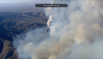
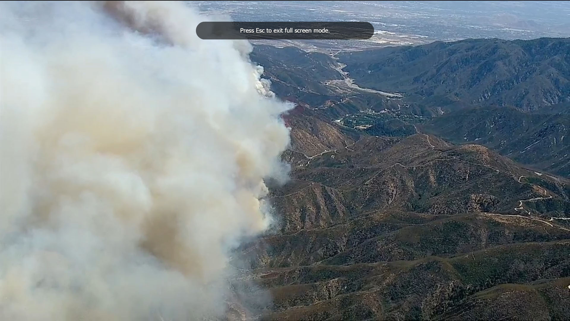
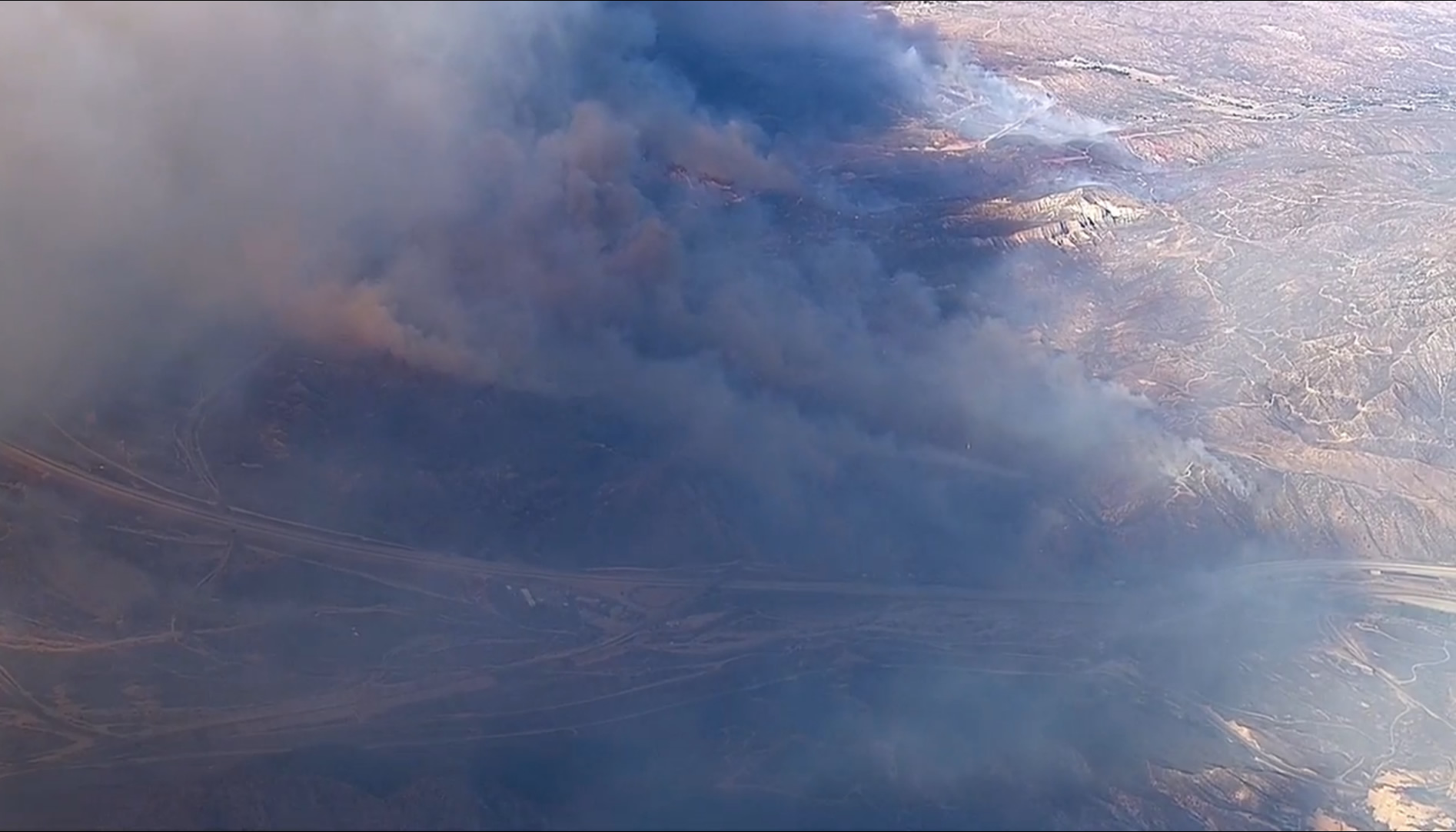
Dragon, Wed Aug 17 2016, 08:18AM
Captures from the ABC chopper at 7am showing most active burning towards Wrightwood. The 138 is the most visible road in the lower left, the camera is looking SSW, and the densest smoke is coming from around 34.338966, -117.565141 GPS coordinates (based on matching the view on Google Earth):
This shows 138 before it rises to intersect highway 2 at the top of the hill towards the top right. A lot of areas along 138 in this image were burned, but it's not easy to see from this distance. It surprises me how little smoke there is.
Re: BlueCut Fire 8-16-2016 (Cajon Pass)
SCM ALERT🚨, Wed Aug 17 2016, 08:25AM
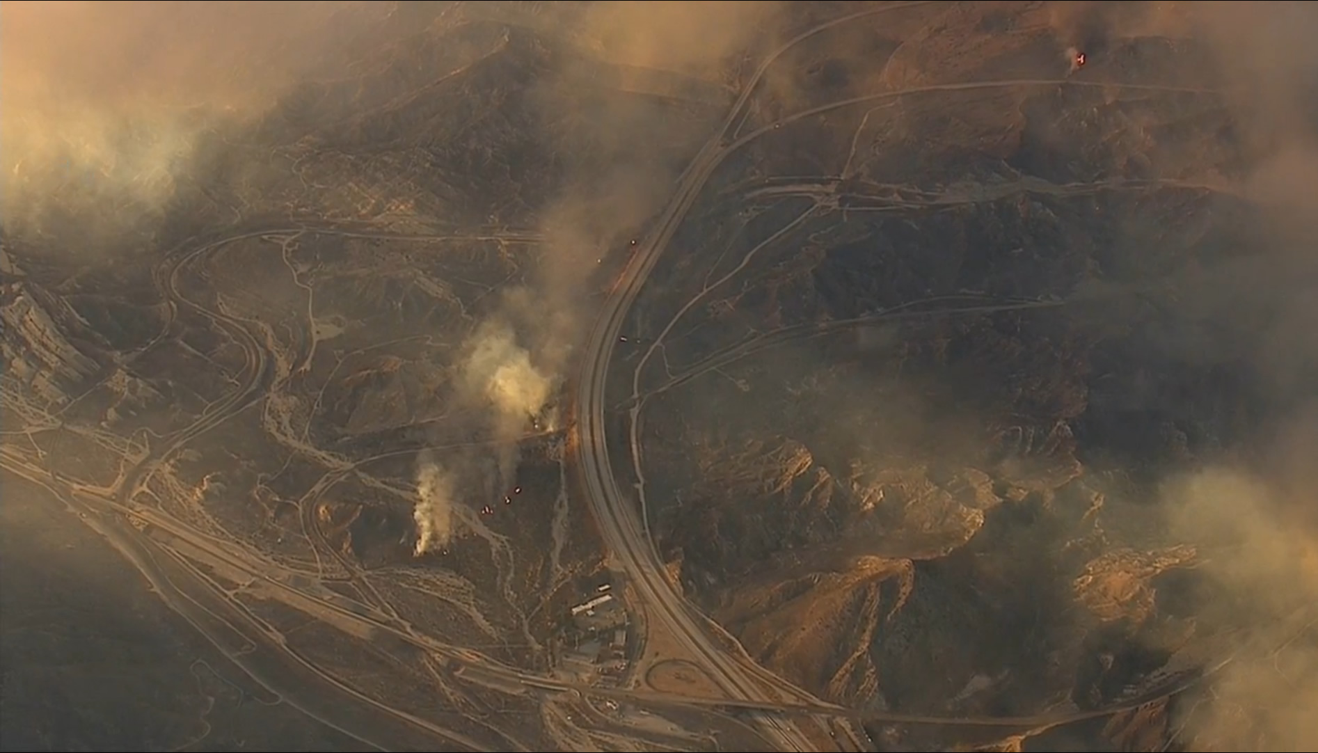
Some bulldozer work from last night...
Re: BlueCut Fire 8-16-2016 (Cajon Pass)
Craig ⭐, Wed Aug 17 2016, 08:27AM
BlueCut Operational Map for Wednesday Aug 17th
(Click to enlarge)
Re: BlueCut Fire 8-16-2016 (Cajon Pass)
BrownBear, Wed Aug 17 2016, 08:34AM
YESTERDAY.....my son on the roof. You can see why we were all concerned! (And packed up)
Re: BlueCut Fire 8-16-2016 (Cajon Pass)
Dragon, Wed Aug 17 2016, 08:38AM
I made a map of the fire progress towards Wrightwood. Looks like it moved about 1.09 miles between 8pm and 7am. There's a wide, flat valley between Wrightwood and the fire where they should be able to stop it, if not earlier.

Re: BlueCut Fire 8-16-2016 (Cajon Pass)
BrownBear, Wed Aug 17 2016, 08:42AM
YESTERDAY. Mask bought for fun/prop but great day to try it on.

Re: BlueCut Fire 8-16-2016 (Cajon Pass)
Dragon, Wed Aug 17 2016, 09:16AM
Highlights from the press conference:
Incident commander says he's never seen fire behavior like this in 40 years.
"Fires are burning at unprecedented rate. Explosive fire growth is the new normal this year."
"It hit with an intensity we haven't seen before and a very wide front."
There is a lot of national infrastructure at risk in Cajon pass.
"If we ask you to leave, you have to leave. The worst thing to happen is if you wait till the last minute, dial 911, fire fighters are unable to get people out of their homes. ... [Please] heed what the Sheriff's department is putting out to you."
100 personnel working on evacuations. Evacuated 35k homes, 80k residents.
Evac area spread west a bit this morning.
15 and 138 still closed. They're doing everything they can to open it as soon as possible. Fire did significant damage to guard rails and power lines. 50 personnel dedicated.
Commercial vehicles have been using 138 and getting stuck, affecting fire ops.
Re: BlueCut Fire 8-16-2016 (Cajon Pass)
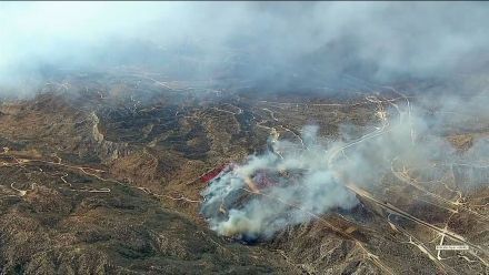
Dragon, Wed Aug 17 2016, 09:38AM
These photos from the ABC chopper yesterday look like a bombing (again, these are from yesterday, not today):

Re: BlueCut Fire 8-16-2016 (Cajon Pass)
SCM ALERT🚨, Wed Aug 17 2016, 10:10AM
Per Inciweb:
There is imminent threat to public safety, rail traffic and structures in the Cajon Pass, Lytle Creek, Wrightwood, Oak Hills, and surrounding areas. Please follow the evacuation instructions, as this is a very quickly growing wildfire. An estimated 34,500 homes and 82,640 people are being affected by the evacuation warnings.
Re: BlueCut Fire 8-16-2016 (Cajon Pass)
BrownBear, Wed Aug 17 2016, 12:56PM
20 mins ago from a Wrightwood neighborhood

Re: BlueCut Fire 8-16-2016 (Cajon Pass)
BrownBear, Wed Aug 17 2016, 01:01PM
Red Cross providing relief at Sultana High School Hesperia. This time people ARE using this shelter. Husband says they have drinks, and hot food, and info

Re: BlueCut Fire 8-16-2016 (Cajon Pass)
campingmom, Wed Aug 17 2016, 01:12PM
From the cam at Mt. Hardware in Wrightwood
Re: BlueCut Fire 8-16-2016 (Cajon Pass)
NShore.Allen, Wed Aug 17 2016, 01:32PM
From north OC the smoke is coming up behind Baldy
Re: BlueCut Fire 8-16-2016 (Cajon Pass)
Dragon, Wed Aug 17 2016, 01:36PM
I don't know what they're doing on 138 between 18 and top town (a friend implied they were working on the guard rail but I dont think they're putting a guard rail in that stretch) but we avoided it by coming on 18 the whole way from Lake Gregory. No significant traffic. Lots of dark smoke visible off towards Lytle Creek.
Anyone looking for real time traffic updates, turn on the traffic layer turned on using the menu in the top left of Google Maps. That's how we avoided the dark dark red between 18 and top town (actually it extends almost all the way to Lake Gregory and seems to be mostly affecting north bound traffic at this point, causing backup on 18 as people try to get on 138).
Re: BlueCut Fire 8-16-2016 (Cajon Pass)
SCM ALERT🚨, Wed Aug 17 2016, 02:22PM
Branch 1 Operational Map
(click to enlarge)
Re: BlueCut Fire 8-16-2016 (Cajon Pass)
campingmom, Wed Aug 17 2016, 02:28PM
Hardware Store in Wrightwood. Not good. Shared same view a few minutes ago now much worse.

Re: BlueCut Fire 8-16-2016 (Cajon Pass)
SCM ALERT🚨, Wed Aug 17 2016, 02:31PM
Wow, that is scary!!!
Re: BlueCut Fire 8-16-2016 (Cajon Pass)
RvnNtheSnw, Wed Aug 17 2016, 03:27PM
Traffic on highway 138 in crestline is being directed by chp. The back up is pretty bad, but it is at least controlled. If you are a local and need to go down 18, I recommend going up to 18 via lake gregory drive and then taking the narrows down. Avoid top town if you can. Traffic at the turn off heading up is pretty bad. Take the narrows if you need to come into crestline and then come down lake gregory drive.
Re: BlueCut Fire 8-16-2016 (Cajon Pass)
Benny ⭐, Wed Aug 17 2016, 05:08PM
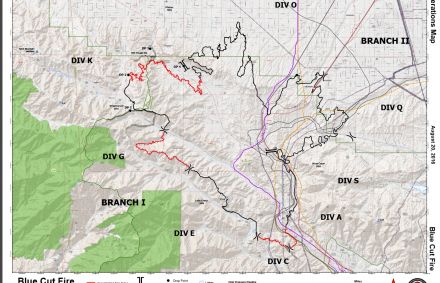
Latest burn update & division map.
CLICK TO ENLARGE
Re: BlueCut Fire 8-16-2016 (Cajon Pass)
Craig ⭐, Wed Aug 17 2016, 05:20PM
Per Scanner: Fire is crossing Hwy 2 at Desert Front north of Wrightwood.
See Map Below (click to enlarge)
Re: BlueCut Fire 8-16-2016 (Cajon Pass)
Benny ⭐, Wed Aug 17 2016, 05:24PM
Here's a little better map....

Re: BlueCut Fire 8-16-2016 (Cajon Pass)
BrownBear, Wed Aug 17 2016, 05:28PM
Pacific Crest area Wrightwood I have no info of what time
Re: BlueCut Fire 8-16-2016 (Cajon Pass)
DHRacer, Wed Aug 17 2016, 06:56PM
To add on to what RvnNtheSnw said, the 18 wasn't as bad today as yesterday going northbound from San Bernardino to Crestline. Southbound on the 18 this morning was decent as well.
I figure a lot of people stayed home today.
Can't tell you how it is in Crestline, I go past it on the 18, but I'd recommend the tip on going Lake Gregory Drive in and out of Crestline for residents there.
DHR
Re: BlueCut Fire 8-16-2016 (Cajon Pass)
booboo, Wed Aug 17 2016, 08:48PM
OK,from VOE or Crestline the 138 down is open.At the bridge with the temporary stoplight backup about 50 cars.From there you can go out 173 to the right,138 is blocked per family member
Re: BlueCut Fire 8-16-2016 (Cajon Pass)
booboo, Wed Aug 17 2016, 08:50PM
DHRacer wrote ...
Can't tell you how it is in Crestline, I go past it on the 18, but I'd recommend the tip on going Lake Gregory Drive in and out of Crestline for residents there.
DHR
45 minute backup from Crestline cutoff to top town about 430 PM today,great tip on Lake Gregory drive.Can't tell you how it is in Crestline, I go past it on the 18, but I'd recommend the tip on going Lake Gregory Drive in and out of Crestline for residents there.
DHR
Re: BlueCut Fire 8-16-2016 (Cajon Pass)
Mtngoat John⭐, Wed Aug 17 2016, 09:45PM
New map up on Inciweb
[Click Here]
Re: BlueCut Fire 8-16-2016 (Cajon Pass)
SCM ALERT🚨, Wed Aug 17 2016, 10:11PM
PER MANY FOLKS HERE ON SCM AND ALSO CHP CAD:
NORTHBOUND INTERSTATE 15 WILL REOPEN SHORTLY. SOUTHBOUND INTERSTATE 15 WILL REMAIN CLOSED UNTIL FURTHER NOTICE. THANK YOU TO ALL FOR YOUR REPORTS AS WE MOVE THROUGH THIS INCIDENT.
Re: BlueCut Fire 8-16-2016 (Cajon Pass)
Lumber Jill, Thu Aug 18 2016, 08:35AM
Forest Service update:
Acreage increased to 31,689 Containment at 4% Northbound Interstate 15 opened at 10:15PM last night, southbound remains closed.
blue_cut_fire_update_08_18_16_am.pdfRe: BlueCut Fire 8-16-2016 (Cajon Pass)
Dragon, Thu Aug 18 2016, 08:45AM
MODIS data from 10:45pm and 3am:

Re: BlueCut Fire 8-16-2016 (Cajon Pass)
Dragon, Thu Aug 18 2016, 09:13AM
Water drop chopper with enhancement:
Re: BlueCut Fire 8-16-2016 (Cajon Pass)
Dragon, Thu Aug 18 2016, 11:12AM
People were asking where to find maps on inciweb and I didn't even notice myself until Mtn goat John mentioned that they have a dedicated Maps link near the top right:

Re: BlueCut Fire 8-16-2016 (Cajon Pass)
Dragon, Thu Aug 18 2016, 01:38PM
MODIS has a new fire perimeter so I combined it with the map from yesterday to show fire growth. No new MODIS data points have appeared yet today.
Re: BlueCut Fire 8-16-2016 (Cajon Pass)
BrownBear, Thu Aug 18 2016, 02:00PM
Right now top of cajon pass west side...still smoldering. Oak Hills exit/onramp
Re: BlueCut Fire 8-16-2016 (Cajon Pass)
BrownBear, Thu Aug 18 2016, 02:02PM
Another shot more to the right/west of oak hill at the top

Re: BlueCut Fire 8-16-2016 (Cajon Pass)
Craig ⭐, Thu Aug 18 2016, 05:42PM
Thanks for the great pictures, maps, etc everyone! You all ROCK!!!! Dragon, when you were gone that one day, I was very depressed
Re: BlueCut Fire 8-16-2016 (Cajon Pass)
Dragon, Thu Aug 18 2016, 05:44PM
An 8 minute interview with the fire chief: [Click Here]
He reiterates that they haven't seen fires move like this before. Winds are up to 40mph through the Cajon pass. Humidity under 10 percent is not normal for August. It's as dry as during Santa Ana wind conditions, but without that dry wind from the north. Soil moisture is at "critical" levels. The plants "look green, but they burn like they're dead".
They can't put hand crews up in the hills because it's too dangerous, so they build thick lines of phos-chek instead. A lot of fighters were working on no sleep till yesterday when extra fire fighters got down from Northern California.
The chief cautioned that this is still considered to be early in the fire season and that it will get even dryer and warmer.
A viewer asked if this was the worst it's ever been. The chief said that's a subjective question but these are the worst conditions he's seen in his 25 years, and he's talked to 40-year veterans who work across the country and agree they've never seen anything like this in our area at this time of year.
The reporter mentioned the Cedar fire which killed 15 people and burned 3000 homes stands out as the worst in his memory. Chief agreed that one was bad and pointed out that we often refer back to the Old Fire and Grand Prix fires which met in Cajon pass in 2003, the same year as Cedar 100 miles to our south.
He ended with an explanation that the fire moves fastest when the wind direction blows it up slope and when the sun is at the worst angle to that slope (at a perpendicular angle, I assume). He pointed to a section of black smoke in the video as being "a very angry fire".
Re: BlueCut Fire 8-16-2016 (Cajon Pass)
campingmom, Thu Aug 18 2016, 07:29PM
And we haven't gotten to Oct and Santa Ana's yet. Kinds of worrisome for sure.
Re: BlueCut Fire 8-16-2016 (Cajon Pass)
Mtngoat John⭐, Thu Aug 18 2016, 10:06PM
Photo taken last night at 10:36pm.
Photo Courtesy NASA Earth Observatory
(click photo to enlarge)

Re: BlueCut Fire 8-16-2016 (Cajon Pass)
Craig ⭐, Thu Aug 18 2016, 10:32PM
Wow, incredible perspective there Mr Goat. Thank you so much for that. Now off to figure out all my bearings on that shot!
Re: BlueCut Fire 8-16-2016 (Cajon Pass)
Mtngoat John⭐, Fri Aug 19 2016, 06:38AM
Todays OP's Map showing uncontrolled lines and current containment lines
ops_arch_e_land_2016_blue_cut_cabdf00701_lr.pdfRe: BlueCut Fire 8-16-2016 (Cajon Pass)
Dragon, Fri Aug 19 2016, 07:54AM
MODIS data from 2:05am:
Re: BlueCut Fire 8-16-2016 (Cajon Pass)
SCM ALERT🚨, Fri Aug 19 2016, 09:51AM
Thank you Mr. Dragon! You are the best!
Re: BlueCut Fire 8-16-2016 (Cajon Pass)
SCM ALERT🚨, Fri Aug 19 2016, 10:09AM
BlueCut IR and Perimeter map as of earlier this morning (Aug 8/19):
(click map to enlarge it)
Re: BlueCut Fire 8-16-2016 (Cajon Pass)
bills grandson, Fri Aug 19 2016, 10:53AM
That shot from space is hard to believe. but it appears to be a regular N S perspective The fire has traveled further East then what I understood. But if you look at it and the map posted just before this you can make sense of it. If that is possible. Most of the focus has been towards Wrightwood which is where the typical Cajon fires head Everything else is unusual. one branch goes towards the summit but the main fire goes up the valley toward Wrightwood. I don't recall one ever getting this far or spreading like it has. Those first couple hours was like nothing I have never seen. They need an very wide firebreak from the tracks to the West. Not seeing where it started these things often are caused by trains with hot brakes. I don't recall one burning in that section towards Baldy before that might be why it is so intense. Hopefuly they will get a handle on it soon
Re: BlueCut Fire 8-16-2016 (Cajon Pass)
Dragon, Fri Aug 19 2016, 08:53PM
MODIS data from 11:30am plus fire growth lines:

Notice the growth lines imply fire swept through Lytle Creek today, but the MODIS heat dots show that part of the spread actually happened yesterday. There was only one big source of heat left at 11am today as marked by the blue dot.
Re: BlueCut Fire 8-16-2016 (Cajon Pass)
Lumber Jill, Sat Aug 20 2016, 06:30AM
News Release - Blue Cut Fire - INCIDENT COMMANDERS ASK FOR PUBLIC’S HELP
FOR IMMEDIATE RELEASE
Friday, August 19, 2016 9:00 p.m.
On Scene Media Contact Information: (909) 473-0774
Fire Information Line: (909) 383-5688
The Blue Cut Fire remains under investigation, however, the Unified Incident Commanders have determined that the public’s assistance is needed.
Anyone who may have been in or around the area of southbound Interstate 15 between Cleghorn and Kenwood Roads or along Old Cajon Boulevard through this same section on Tuesday, August 16th, between 10:00 am and 11:00 am and believe that they may have seen something suspicious is asked to share that information.
If you believe you have information, photos, or video of this area in this time frame, please call 1-800-78-CRIME (27463) or on the web at [Click Here]
The Blue Cut Fire started on Tuesday, August 16th, and has so far burned 37,020 acres, destroyed 105 homes, 216 outbuildings and is at 40% containment.
All calls can remain confidential. Thank you for your assistance in this ongoing investigation.
John Miller
Public Affairs Officer
Forest Service
San Bernardino National Forest
p: 909-382-2788
f: 909-383-5770
jmiller02©fs.fed.us
602 South Tippecanoe Avenue
San Bernardino, CA 92408
[Click Here]
[Click Here]
![[Click Here]](Twitterhttp://wwwstatic.fs.usda.gov/images/facebook.png)
Re: BlueCut Fire 8-16-2016 (Cajon Pass)
Lumber Jill, Sat Aug 20 2016, 06:33AM
Forest Service updatefrom last night:
Highlights:
Acreage rises to 37,020 and containment jumps to 40%.
Evacuation areas reduced, and State Highway 138 re-opens east of Interstate 15
blue_cut_fire_update_20160819_pm.pdfRe: BlueCut Fire 8-16-2016 (Cajon Pass)
Lumber Jill, Sat Aug 20 2016, 10:11AM
Forest Service morning update:
Highlights: Acreage remains unchanged, containment rises to 68% as firefighters work around the clock to fully contain the fire.
blue_cut_fire_update_20160820_am.pdfRe: BlueCut Fire 8-16-2016 (Cajon Pass)
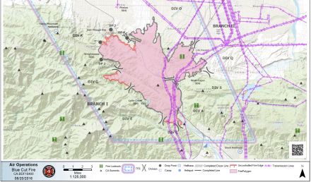
Craig ⭐, Sat Aug 20 2016, 11:45AM
SAT AUGUST 20 AIR OPERATIONS MAP
(Click Map to Enlarge)
Re: BlueCut Fire 8-16-2016 (Cajon Pass)
Craig ⭐, Sat Aug 20 2016, 11:46AM
SAT AUGUST 20 CONTAINMENT MAP
(click map to enlarge)
Re: BlueCut Fire 8-16-2016 (Cajon Pass)
Craig ⭐, Sat Aug 20 2016, 11:47AM
PER SBNF TWITTER: MANDATORY EVACS FOR WRIGHTWOOD WILL BE REDUCED TO VOLUNTARY AT 12 NOON. RESIDENTS ONLY. ID REQUIRED
Re: BlueCut Fire 8-16-2016 (Cajon Pass)
Lumber Jill, Sat Aug 20 2016, 09:54PM
Forest Service update:
Highlights: Containment jumps to 73%, residents return to Wrightwood.
Re: BlueCut Fire 8-16-2016 (Cajon Pass)
Lumber Jill, Sat Aug 20 2016, 09:59PM
Sorry...my phone doesn't want to upload the update :/
Re: BlueCut Fire 8-16-2016 (Cajon Pass)
Benny ⭐, Sat Aug 20 2016, 09:59PM
Lumbe® Jill wrote ...
Sorry...my phone doesn't want to upload the update :/
Sorry...my phone doesn't want to upload the update :/
Gotcha covered!
Update August 20th, 2016, 7:00 p.m.
Location: Devore, California
Date and Time of Fire Start: August 16, 2016, 10:44 a.m.
Cause: Under Investigation
Size: 37,020 acres Containment: 73 percent
Management: California Interagency Incident Management Team 4
Cooperating Agencies: BNSF Railway, Union Pacific Railway, Cal Trans, Southern California Edison, LA DWP, American Red Cross, San Bernardino Animal Control, California Department of Corrections and Rehabilitation and the California Highway Patrol
Fire Status: Firefighters continued to extinguish hot spots within fire lines. The work of firefighters and utility crews enabled the lifting of the mandatory evacuation of Wrightwood which is now open to residents. Tonight firefighters will continue to work aggressively to complete containment lines and reinforce existing lines. Utility companies will continue work to replace damaged or destroyed infrastructure. The fire has destroyed 105 single family homes and 213 other minor structures. For information on damaged or destroyed homes please contact the Local Assistance Center at 760-539-3093 between 8:00 a.m. and 5:00 p.m.
Resources:
Hand Crews: 46 Engines: 177 Dozers: 29 Water Tenders: 25 Helicopters: 9
Closure Update as of 7:00 p.m.:
• Highway 138 is closed between Beekley Rd and Interstate 15
• State Route 2 is closed from LA County line to the 138
• Old Cajon Blvd. north of Devore
• Lytle Creek Rd. at Glen Helen Parkway
• Lone Pine Canyon Rd. from East Canyon Drive through Highway 138
• Swarthout Canyon Road to Cajon Boulevard
Mandatory Evacuation:
Community of Lytle Creek and West Cajon Valley
Voluntary Evacuation:
• The community of Wrightwood is open to residents with proof of address
Evacuation Centers:
Jessie Turner Community Center San Bernardino County Fairgrounds
15556 Summit Avenue 14800 Seventh St.
Fontana, CA Victorville, CA
Further Information: Information Call Center (909) 383-5688 or
[Click Here]
Re: BlueCut Fire 8-16-2016 (Cajon Pass)
Lumber Jill, Sun Aug 21 2016, 06:55AM
Thanks Beanie!
Re: BlueCut Fire 8-16-2016 (Cajon Pass)
Mtngoat John⭐, Sun Aug 21 2016, 08:33AM
Current map showing containment lines
(click image to enlarge)

Re: BlueCut Fire 8-16-2016 (Cajon Pass)
Mtngoat John⭐, Tue Aug 23 2016, 08:36PM
Pretty incredible set of photos put together by the SB Sun. 150 or so of them.
[Click Here]
Re: BlueCut Fire 8-16-2016 (Cajon Pass)
Cornbread, Wed Aug 24 2016, 10:37AM
Mtn goat John wrote ...
Pretty incredible set of photos put together by the SB Sun. 150 or so of them.
[Click Here]
Pretty incredible set of photos put together by the SB Sun. 150 or so of them.
[Click Here]
Great pic's but sad too
Re: BlueCut Fire 8-16-2016 (Cajon Pass)
©ammy, Wed Aug 24 2016, 09:36PM
This one is amazing!

Re: BlueCut Fire 8-16-2016 (Cajon Pass)
Lumber Jill, Fri Sep 02 2016, 11:07AM
Blue Cut Update
Re: BlueCut Fire 8-16-2016 (Cajon Pass)
Lumber Jill, Fri Sep 02 2016, 04:07PM
Forest Service Closes Blue Cut Fire Area to Public Use
SAN BERNARDINO, California, September 2, 2016 – To address public safety concerns, the San Bernardino National Forest issued today an Area Closure for the Blue Cut Fire effective Saturday, September 3, 2016.
The area closure is intended to keep the public safe from post-fire hazards such as falling snags, rolling debris and water run-off. Simply being in the area where these types of hazards exist possess a significant risk to the public.
“Wildfires on our public lands often leave fragile and very unsafe conditions on the landscape that can be dangerous to forest visitors,” said Elrand Denson, Deputy Forest Supervisor of the San Bernardino National Forest. “To ensure the public’s safety, a large area of forest that was affected by the Blue Cut Fire has been closed to all public use.”
The Blue Cut Fire area closure specifically prohibits:
· Going into or being upon National Forest System lands within the Blue Cut Fire Closure Area
· Being on any National Forest System trail within the Blue Cut Fire Closure Area, except for the Pacific Crest Trail
· Being on any National Forest System road within the Blue Cut Fire Closure Area
The areas subject to the closure are commonly referred to as the following:
· Upper Lytle Creek Divide Area
· Stockton Flats Area
· Baldy Mesa OHV Staging/Area
· Lost Lake Area
· Applewhite Campground
· Applewhite Truck Trail
· Sheep Canyon Area
· Cajon Wash Area
· Cajon Pass
Forest users are encouraged to contact the Mill Creek Visitor Center at 909 382 2882, prior to visiting the forest if they have specific questions on which roads and trails are closed.
The full text of the order and maps can be found on the San Bernardino National Forest website.
Gregg Goodland
Deputy Public Affairs Officer - Acting
Forest Service
San Bernardino National Forest
Re: BlueCut Fire 8-16-2016 (Cajon Pass)
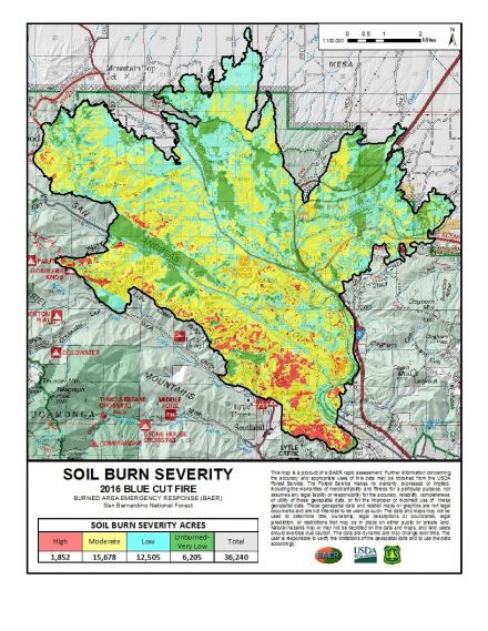
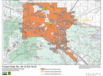
©ammy, Sat Sep 03 2016, 09:09PM
Map of the Blue Cut Fire closure area:
(click on image to enlarge)
Re: BlueCut Fire 8-16-2016 (Cajon Pass)
©ammy, Sat Sep 03 2016, 09:09PM
You've likely seen pictures of a fire camp before, but here's what I'm calling Edison camp: [Click Here]