VALLEY FIRE: HWY 38 BETWEEN MTN HOME VILLAGE AND FOREST FALLS
SCM ALERT🚨, Fri Jul 06 2018, 01:36PM
7/6/2018 - VALLEY FIRE MEDIA AND UPDATES HERE - POST ANY MEDIA / DISCUSSION HERE
13:30 HOURS - 1/4 ACRE
Re: VALLEY FIRE: HWY 38 BETWEEN MTN HOME VILLAGE AND FOREST FALLS
NShore.Allen, Fri Jul 06 2018, 01:45PM
when was the last time this side burned?
Re: VALLEY FIRE: HWY 38 BETWEEN MTN HOME VILLAGE AND FOREST FALLS
SCM ALERT🚨, Fri Jul 06 2018, 01:45PM
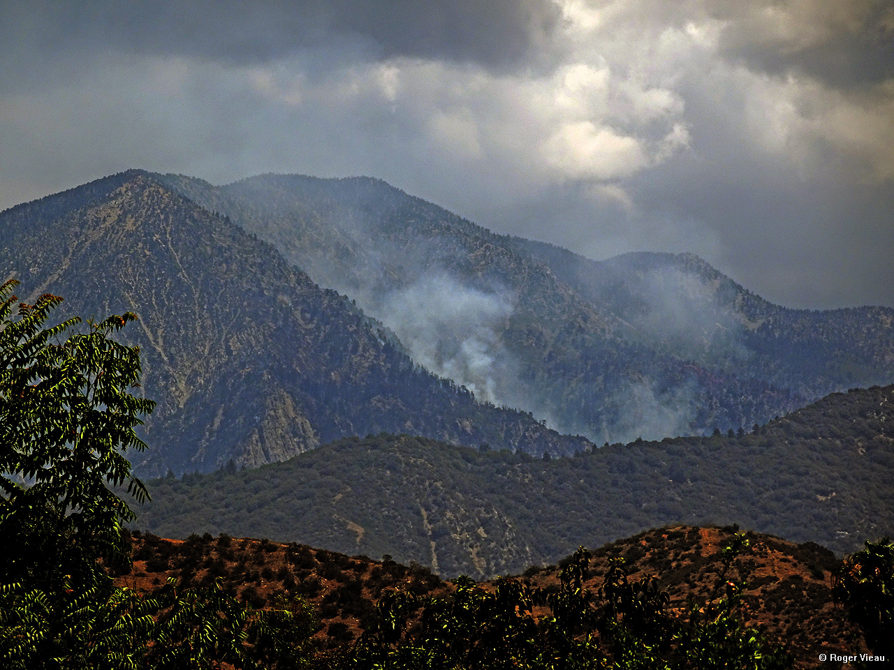
RAPID RATE OF SPREAD - SEVERAL ACRES - MOVING UPSLOPE TOWARD FOREST FALLS. NO STRUCTURE THREAT AT THIS TIME. SIGNIFICANT MULTI-AGENCY RESPONSE ON SCENE OR ENROUTE
Re: VALLEY FIRE: HWY 38 BETWEEN MTN HOME VILLAGE AND FOREST FALLS
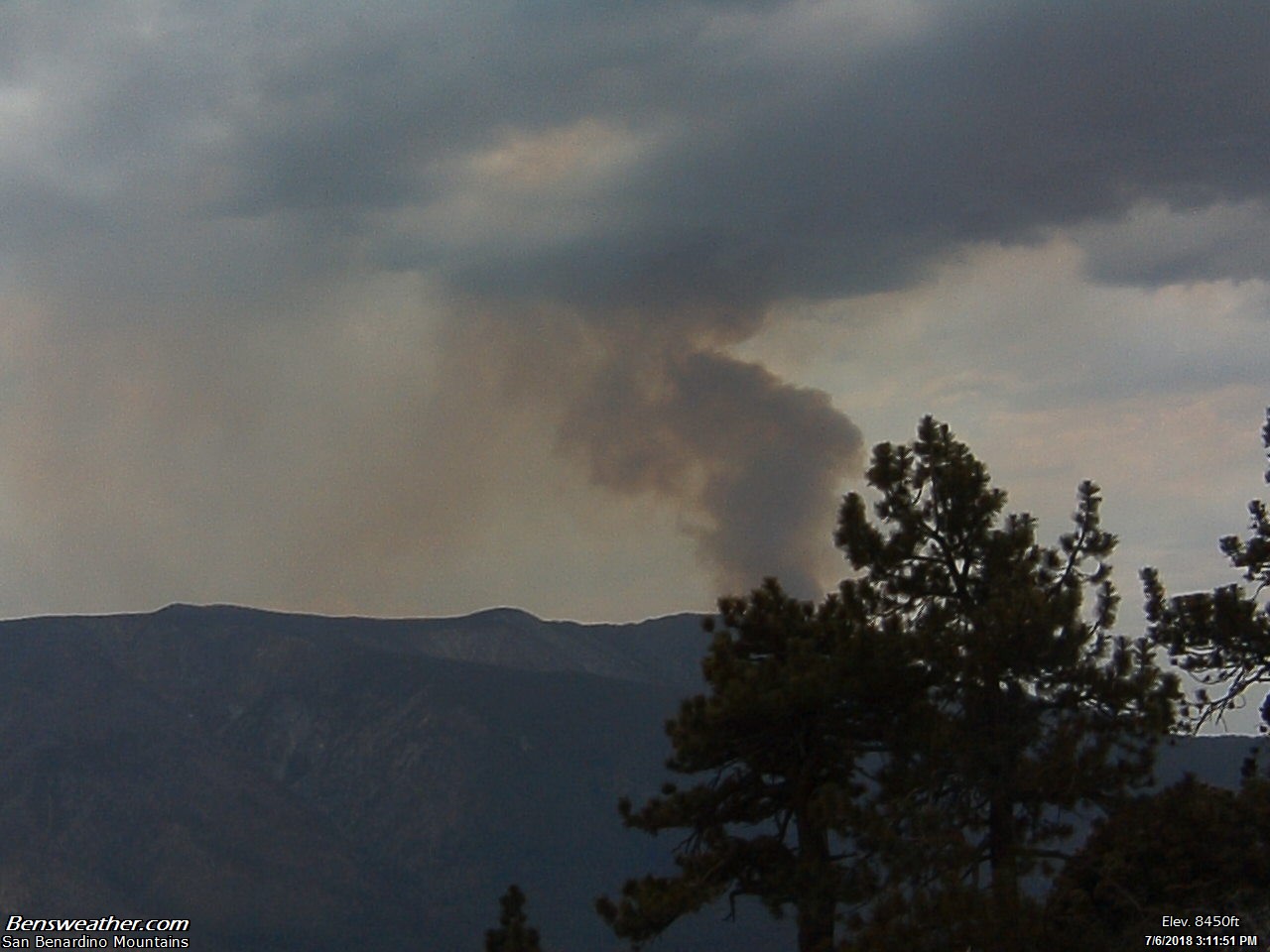
Benny ⭐, Fri Jul 06 2018, 01:57PM
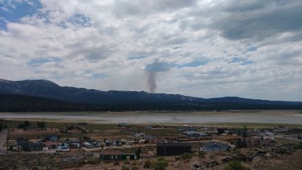
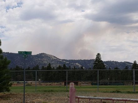
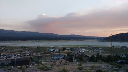
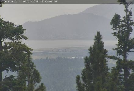
Smoke is visible coming up over the San Gorgonio Wilderness to our south. Fire is no threat at all to the Big Bear Valley.
Live San G Webcam [Click Here]
Re: VALLEY FIRE: HWY 38 BETWEEN MTN HOME VILLAGE AND FOREST FALLS
MrOwl, Fri Jul 06 2018, 02:07PM
Firefighters can't catch a break.
Re: VALLEY FIRE: HWY 38 BETWEEN MTN HOME VILLAGE AND FOREST FALLS
SCM ALERT🚨, Fri Jul 06 2018, 02:08PM
Webcam showing the fire: [Click Here]
Re: VALLEY FIRE: HWY 38 BETWEEN MTN HOME VILLAGE AND FOREST FALLS
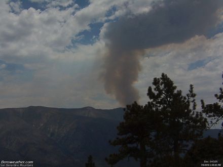
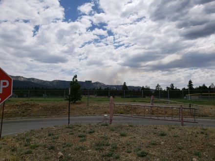
SCM ALERT🚨, Fri Jul 06 2018, 02:22PM
HUGE PLUME OF SMOKE ON THE SAN G CAMERA FROM THIS FIRE:
[Click Here]
Re: VALLEY FIRE: HWY 38 BETWEEN MTN HOME VILLAGE AND FOREST FALLS
doo·hick·ey, Fri Jul 06 2018, 02:25PM
Little mushroom cloud at times. Stay safe everybody.
Re: VALLEY FIRE: HWY 38 BETWEEN MTN HOME VILLAGE AND FOREST FALLS
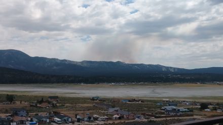
SCM ALERT🚨, Fri Jul 06 2018, 02:27PM
SAN G CAM OF THE VALLEY FIRE AS OF 2:30PM
Re: VALLEY FIRE: HWY 38 BETWEEN MTN HOME VILLAGE AND FOREST FALLS
SCM ALERT🚨, Fri Jul 06 2018, 02:38PM
Webcam view from Mountain Home Village: [Click Here]
Re: VALLEY FIRE: HWY 38 BETWEEN MTN HOME VILLAGE AND FOREST FALLS
doo·hick·ey, Fri Jul 06 2018, 02:47PM
The base got wider and moved west a bit. Looks to be knocked down some. Baldwin winds are coming from the EAST se.
Re: VALLEY FIRE: HWY 38 BETWEEN MTN HOME VILLAGE AND FOREST FALLS
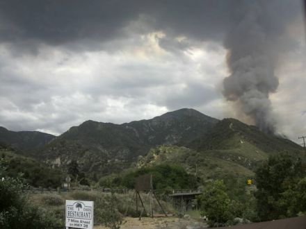
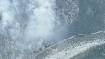
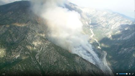
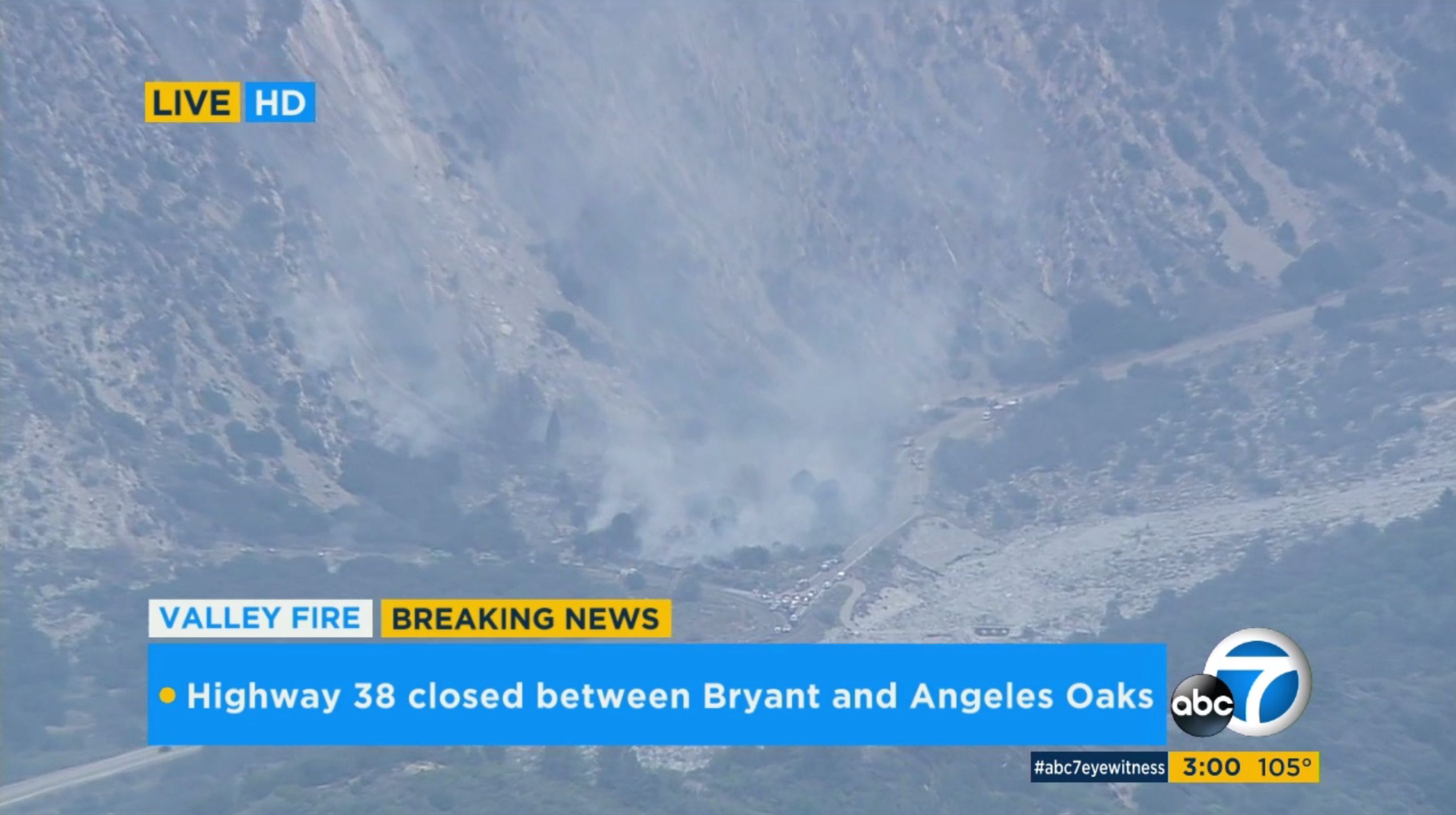
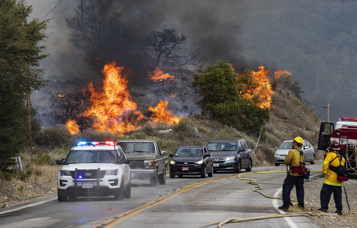
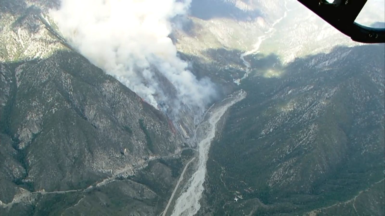
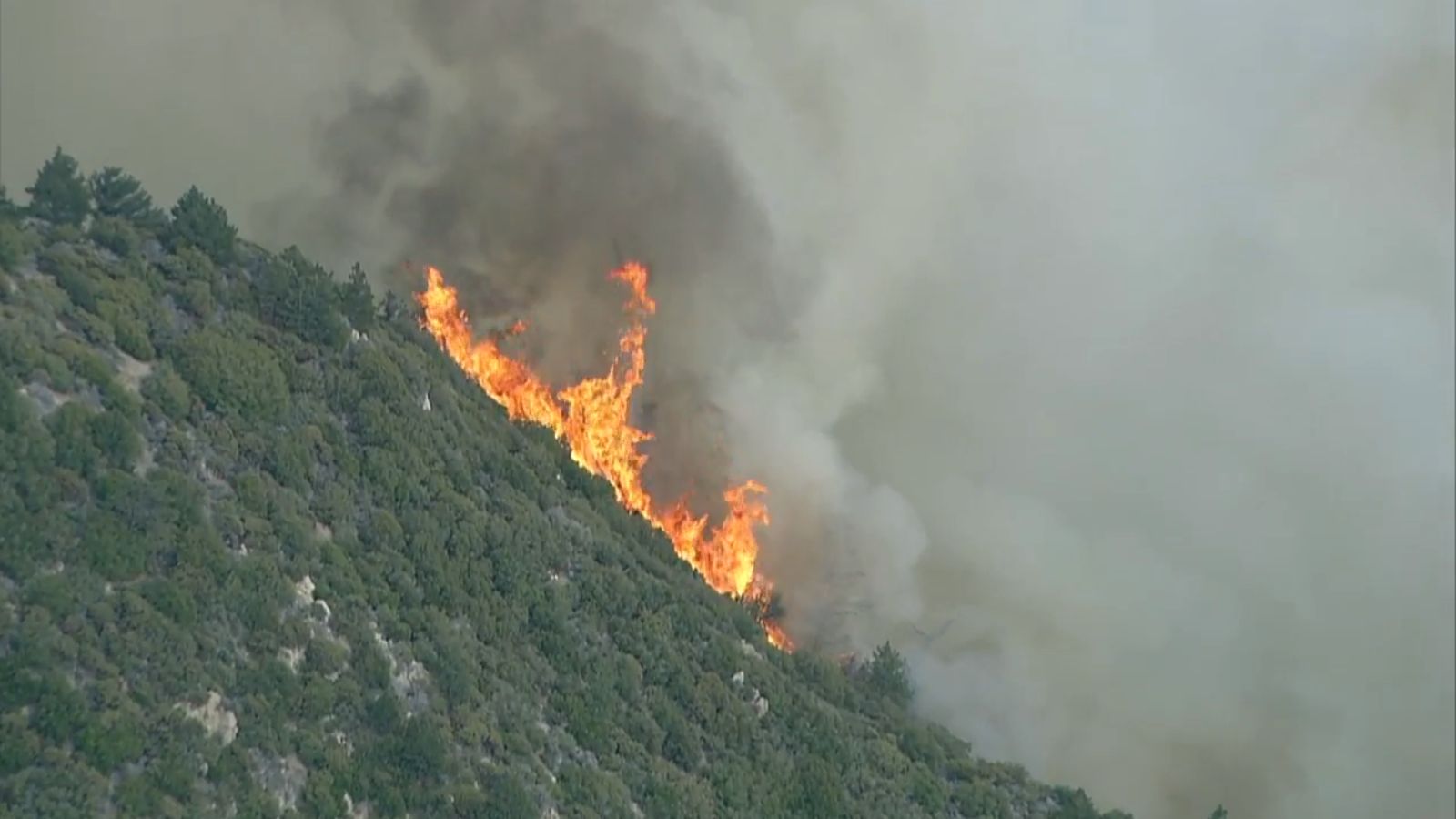
SCM ALERT🚨, Fri Jul 06 2018, 03:02PM
Picture from ABC7 news helicopter:
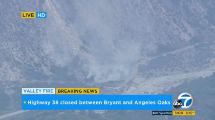
The group of fire vehicles is right at the junction of Hwy. 38 & Valley Of The Falls Drive.
Re: VALLEY FIRE: HWY 38 BETWEEN MTN HOME VILLAGE AND FOREST FALLS
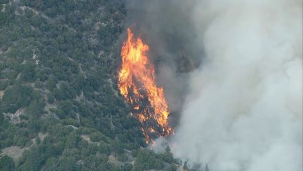
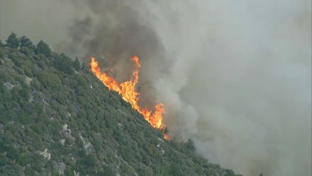
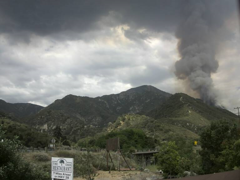
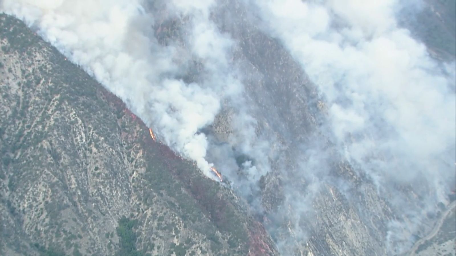
Benny ⭐, Fri Jul 06 2018, 03:13PM
A few more pics.... Valley Fire now over 100 acres with significant growth potential running into the forest.

Re: VALLEY FIRE: HWY 38 BETWEEN MTN HOME VILLAGE AND FOREST FALLS
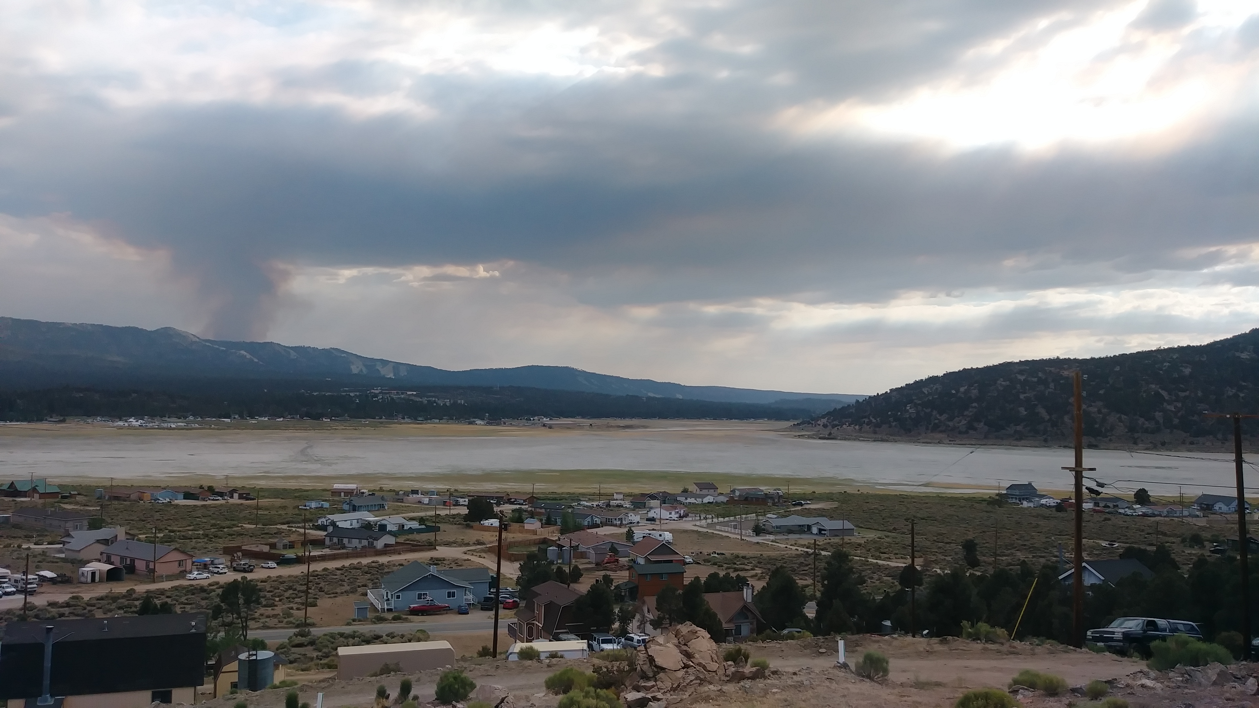
Mtngoat John⭐, Fri Jul 06 2018, 03:34PM
Current view from Mountain Home
Re: VALLEY FIRE: HWY 38 BETWEEN MTN HOME VILLAGE AND FOREST FALLS
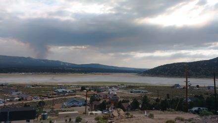
doo·hick·ey, Fri Jul 06 2018, 05:07PM
The smoke plume has nearly reached to over the dump.
Re: VALLEY FIRE: HWY 38 BETWEEN MTN HOME VILLAGE AND FOREST FALLS
Mtngoat John⭐, Fri Jul 06 2018, 05:37PM
Photo courtesy Gina Ferazzi twitter

SBSO escorting residents out of Forest Falls
Re: VALLEY FIRE: HWY 38 BETWEEN MTN HOME VILLAGE AND FOREST FALLS
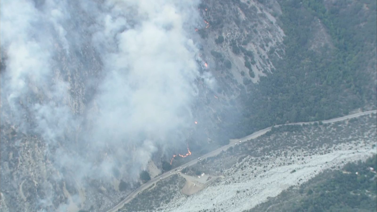
©ammy, Fri Jul 06 2018, 06:03PM
Several screenshots from ABC7 helicopter video from about 15-20 minutes ago:
(Click on images to enlarge)
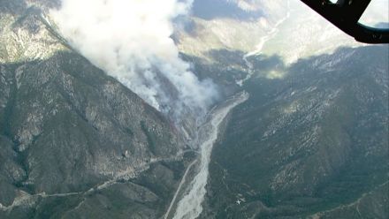

Source: ABC7.com/live
Re: VALLEY FIRE: HWY 38 BETWEEN MTN HOME VILLAGE AND FOREST FALLS
doo·hick·ey, Fri Jul 06 2018, 06:56PM
Winds have been from the South, getting some ash (on my fresh paint) Good luck to all involved.
Re: VALLEY FIRE: HWY 38 BETWEEN MTN HOME VILLAGE AND FOREST FALLS
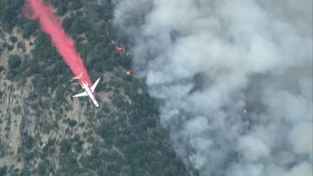
©ammy, Fri Jul 06 2018, 06:57PM
Just caught this retardant drop on the Mtn Home Village cam:
(click on image to enlarge)
Source: [Click Here]
Re: VALLEY FIRE: HWY 38 BETWEEN MTN HOME VILLAGE AND FOREST FALLS
SCM ALERT🚨, Fri Jul 06 2018, 06:58PM
Great shots Cammy!! Nice catch on that drop!
Re: VALLEY FIRE: HWY 38 BETWEEN MTN HOME VILLAGE AND FOREST FALLS
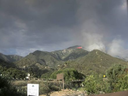
SCM ALERT🚨, Fri Jul 06 2018, 07:04PM
PHOTO FROM THE VALLEY FIRE COURTESY OF FIRE PHOTOGRAPHER EPN105 (CY)

Re: VALLEY FIRE: HWY 38 BETWEEN MTN HOME VILLAGE AND FOREST FALLS
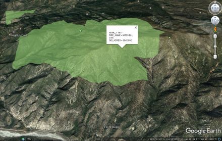
©ammy, Fri Jul 06 2018, 07:05PM
Thanks to MtnGoatJohn sending me a Google Earth file, I was able to find that the area this fire is moving toward last burned in 1977, but there is no record of the area burning where the fire started and is currently burning. And this record goes back to 1878. But I don't know how complete the record is.
In the screenshot below, today's fire started just east of the hairpin turn on Hwy 38 that's just above the "1995" near the lower left of the image:
(click on image to enlarge)
Re: VALLEY FIRE: HWY 38 BETWEEN MTN HOME VILLAGE AND FOREST FALLS
SCM ALERT🚨, Fri Jul 06 2018, 07:11PM
Thanks Cammy! Beyond that 1977 burn isn't the the Lake Fire Burn area behind that?
Re: VALLEY FIRE: HWY 38 BETWEEN MTN HOME VILLAGE AND FOREST FALLS
Polar 🌌rbit, Fri Jul 06 2018, 07:25PM
Lake fire was behind and east. Let;s see if I can paste it here.

Re: VALLEY FIRE: HWY 38 BETWEEN MTN HOME VILLAGE AND FOREST FALLS
©ammy, Fri Jul 06 2018, 07:25PM
Yes.
But that burn scar wasn't listed on this map which only went up through 2013.
Re: VALLEY FIRE: HWY 38 BETWEEN MTN HOME VILLAGE AND FOREST FALLS
Polar 🌌rbit, Fri Jul 06 2018, 07:37PM
How do I attach a jpeg?
Re: VALLEY FIRE: HWY 38 BETWEEN MTN HOME VILLAGE AND FOREST FALLS
doo·hick·ey, Fri Jul 06 2018, 07:58PM
'Choose File' from below
It's kind of getting it's own weather cell up there on top.
Re: VALLEY FIRE: HWY 38 BETWEEN MTN HOME VILLAGE AND FOREST FALLS
Polar 🌌rbit, Fri Jul 06 2018, 08:09PM
OK, maybe got it this time. Lake fire three years ago.

Re: VALLEY FIRE: HWY 38 BETWEEN MTN HOME VILLAGE AND FOREST FALLS
SCM ALERT🚨, Fri Jul 06 2018, 08:11PM
Oh Cool! Thanks Polar! I know it was 3 years ago but that Lake Fire burnt everything I think (mostly timber I think). Maybe that will stop this fire from getting out that way.?
Re: VALLEY FIRE: HWY 38 BETWEEN MTN HOME VILLAGE AND FOREST FALLS
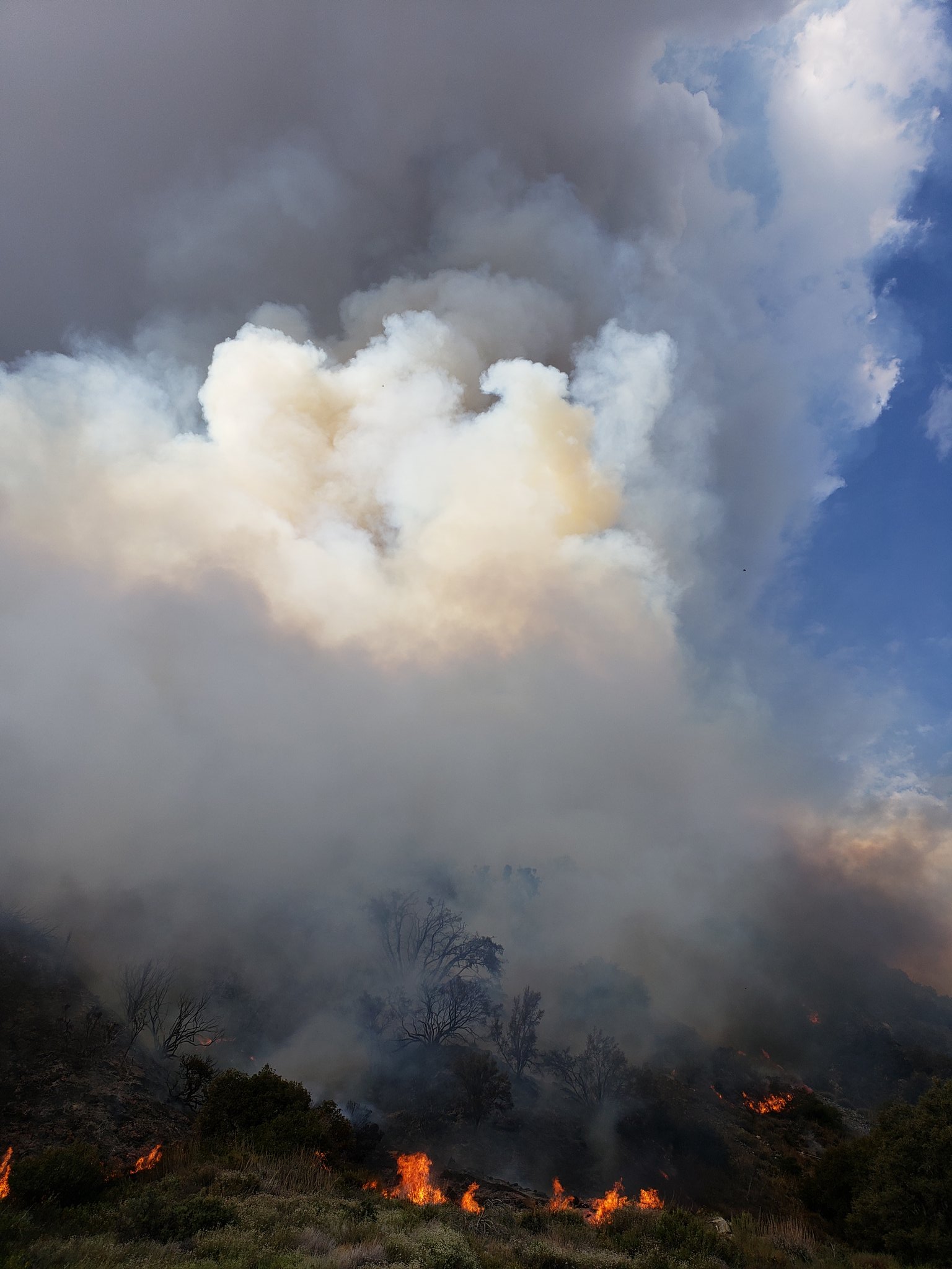
Benny ⭐, Fri Jul 06 2018, 08:13PM
Nice pyrocumulus, if it gets tall enough, it could spark some lightning or a shower.... As the monsoon flow increases through the weekend, humidity should recover and we could see some precip across the mountain top district. Unfortunately, with that comes the potential for strong, erratic winds and lightning.
Re: VALLEY FIRE: HWY 38 BETWEEN MTN HOME VILLAGE AND FOREST FALLS
©ammy, Fri Jul 06 2018, 08:30PM
As night approaches, we're starting to see flames on these 2 webcams:
webcams: [Click Here] [Click Here]
Re: VALLEY FIRE: HWY 38 BETWEEN MTN HOME VILLAGE AND FOREST FALLS
Lumber Jill, Fri Jul 06 2018, 09:03PM
Forest Service Press Release:
Multiple Fires start on the San Bernardino National Forest
SAN BERNARDINO, California, July 6, 2018 –Firefighters from multiple agencies battled record high temperatures and dry conditions in their attempts to control several brush fires on the San Bernardino National Forest.
The Valley Fire quickly grew to 1000 acres as of 8:00 PM after starting at 1:42 in the afternoon. US Forest Service, CAL FIRE, San Bernardino County Fire and San Bernardino County Sheriffs are in Unified Command, working together to suppress the Valley Fire. Mandatory evacuation orders were issued for the community of Forest Falls by the San Bernardino County Sheriff’s office. Structure protection and security are in place if winds push the fire closer to the community. An emergency shelter for displaced residents opened at the Inland Leaders Charter School, 12375 California Street in Yucaipa. Highway 38 is closed to all traffic from Bryant Street in Yucaipa, to Lake Williams Drive near Big Bear. Several trailheads and recreation sites in the Forest Falls have been closed. A specialized Incident Management Team has been requested by the Forest Service to manage this fire.
The Box Fire, which began on the I-15 near Devore, grew to 100 acres before firefighting efforts were able to slow the blaze. Two lanes of I-15 were closed for several hours, leading to traffic congestion for local freeways leading north into the high desert.
Additional fires were reported in the Cajon Pass, and in south Palm Springs near the entrance to Indian Canyon, a popular winter hiking area.
For more information please visit us at [Click Here] , call us at 909-383-5688 or follow us on Twitter at: [Click Here]
Quick Fire Facts: Valley Fire
Fire Start Date: July 6, 2018
Fire Report Time: 1:42 PM
Location: Valley of the Falls Drive, Highway 38,
Acres: 1000 acres,
Fire Cause: Under Investigation
Fire Fighters Assigned: 500
Road Closures: Hwy 38 from Bryant Street to Lake Williams Drive
Evacuations: Community of Forest Falls, including Organization Camps.
Weather: Near record high temperatures, low humidity.
Terrain: Steep, inaccessible mountainsides.
Cooperating Agencies: CAL FIRE, San Bernardino County Fire, San Bernardino County Sheriffs, CHP
Quick Fire Facts: Box Fire
Fire Start Date: July 6, 2018
Fire Report Time: 9:55 AM
Location: Cajon Pass
Acres: 100 acres, 15% contained.
Fire Cause: Under Investigation
Fire Fighters Assigned: 100
Fire Engines: 12
Fire Crews: 3
Road Closures: Two lanes of Northbound 1-15.
Weather: Near record high temperatures, low humidity.
Terrain: Steep, brushy hillsides.
Cooperating Agencies: CAL FIRE, San Bernardino County Fire, CHP.
Re: VALLEY FIRE: HWY 38 BETWEEN MTN HOME VILLAGE AND FOREST FALLS
Benny ⭐, Sat Jul 07 2018, 01:13AM
A few great shots from our field photographer on Friday. Courtesy Cy! Twitter - @epn105


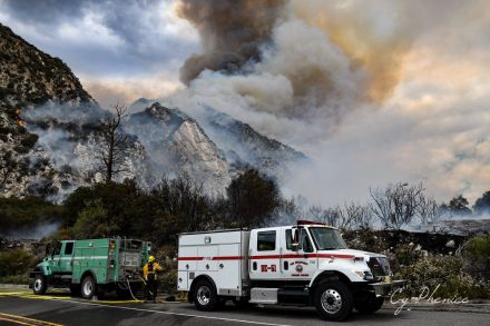
Thanks Cy! Stay safe!
Re: VALLEY FIRE: HWY 38 BETWEEN MTN HOME VILLAGE AND FOREST FALLS
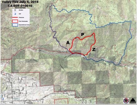
SCM ALERT🚨, Sat Jul 07 2018, 07:53AM
Fire map from this morning's briefing:
(click on image to enlarge)

Photo source: [Click Here]
Re: VALLEY FIRE: HWY 38 BETWEEN MTN HOME VILLAGE AND FOREST FALLS
Socalman, Sat Jul 07 2018, 08:41AM
I was just told by a camp employee in Angelus Oaks that we could get to Ceadar Falls if we tell them we are only going to Angelus Oaks. CAN ANYONE CONFIRM THIS REPORT?
Re: VALLEY FIRE: HWY 38 BETWEEN MTN HOME VILLAGE AND FOREST FALLS
Mtngoat John⭐, Sat Jul 07 2018, 09:06AM
Fire map from Inciweb
Click image to enlarge
Re: VALLEY FIRE: HWY 38 BETWEEN MTN HOME VILLAGE AND FOREST FALLS
SCM ALERT🚨, Sat Jul 07 2018, 09:18AM
Do you have a way to contact anyone at Camp Cedar Falls to find out what they've been told about closures? From what I understand, IF they're going to let anyone through the closures, it would be residents only with ID to get from say the closure at Bryant/Hwy 38 to Mountain Home Village.
Re: VALLEY FIRE: HWY 38 BETWEEN MTN HOME VILLAGE AND FOREST FALLS
SCM ALERT🚨, Sat Jul 07 2018, 09:55AM
Video - driving out of Forest Falls yesterday afternoon: [Click Here]
Re: VALLEY FIRE: HWY 38 BETWEEN MTN HOME VILLAGE AND FOREST FALLS
SCM ALERT🚨, Sat Jul 07 2018, 11:01AM
Thats a SCARY drive! Thanks for sharing that.
Re: VALLEY FIRE: HWY 38 BETWEEN MTN HOME VILLAGE AND FOREST FALLS
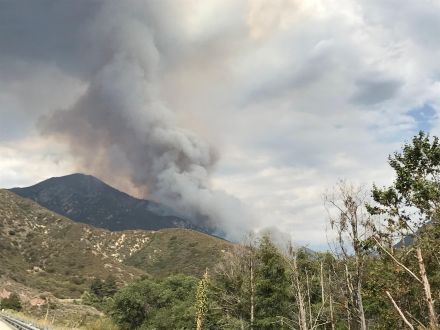
SCM ALERT🚨, Sat Jul 07 2018, 11:20AM
Photo of Valley Fire from yesterday when it was burning hot...
(Courtesy Inciweb - click to enlarge)
Re: VALLEY FIRE: HWY 38 BETWEEN MTN HOME VILLAGE AND FOREST FALLS
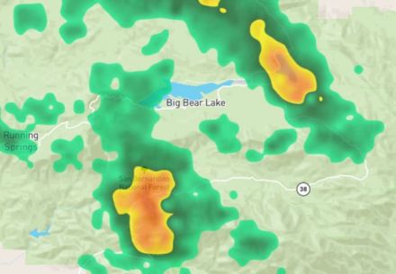
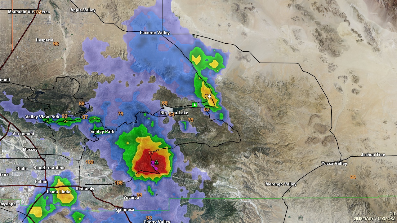
Polar 🌌rbit, Sat Jul 07 2018, 12:31PM
Looks like Baldwin Lake won't be an oxymoron for a day or so. Also, looks like valley fire is getting some good rain, at least on the west end. Now we get mudslides.
Re: VALLEY FIRE: HWY 38 BETWEEN MTN HOME VILLAGE AND FOREST FALLS
SCM ALERT🚨, Sat Jul 07 2018, 12:41PM
It never ends for us does it? When the fire isn't burning the mud is flowing. When nothing else is going on the earth is shaking. We just can't catch a break
Re: VALLEY FIRE: HWY 38 BETWEEN MTN HOME VILLAGE AND FOREST FALLS
Benny ⭐, Sat Jul 07 2018, 12:45PM
Did receive some heavy rainfall over the Valley fire today from a strong to severe thunderstorm in the area. Most areas in the east end of the Valley also picked up around an inch of rain.

Re: VALLEY FIRE: HWY 38 BETWEEN MTN HOME VILLAGE AND FOREST FALLS
SCM ALERT🚨, Sat Jul 07 2018, 01:44PM
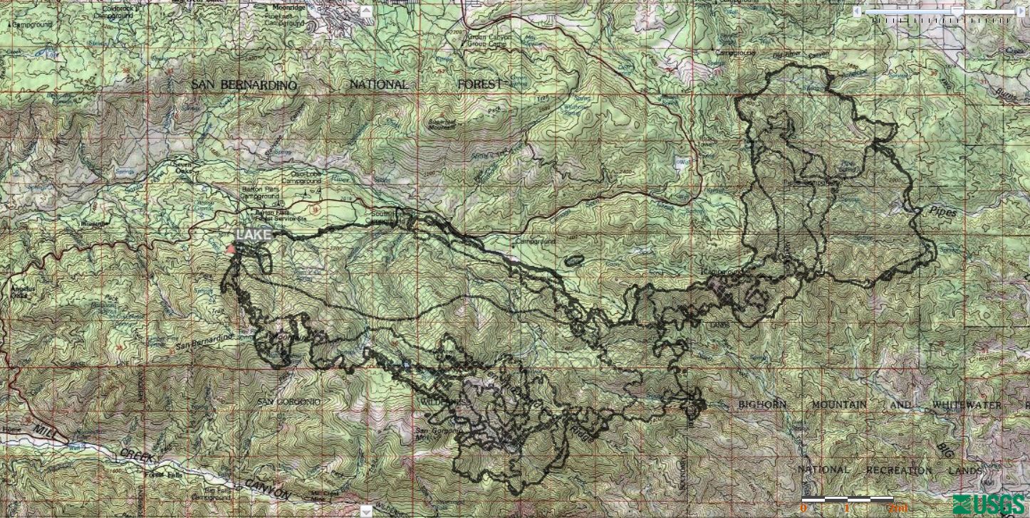
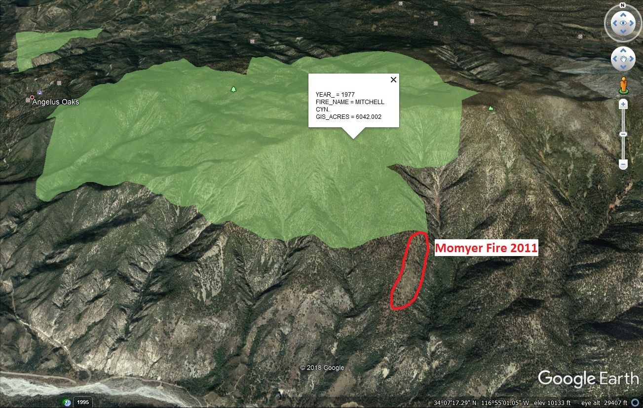
I just remembered the Momyer Fire from back in 2011 burned APPROXIMATELY in the area outlined in red on the map below. The current Valley Fire is burning APPROXIMATELY west (left) of the Momyer Fire scar and south of (below) the Mitchell Fire area highlighted in green.

Re: VALLEY FIRE: HWY 38 BETWEEN MTN HOME VILLAGE AND FOREST FALLS
SCM ALERT🚨, Sat Jul 07 2018, 01:57PM
Forest Service says 5% containment on the Valley Fire.
Re: VALLEY FIRE: HWY 38 BETWEEN MTN HOME VILLAGE AND FOREST FALLS
SCM ALERT🚨, Sat Jul 07 2018, 02:05PM
Inciweb link for Valley Fire: [Click Here]
Re: VALLEY FIRE: HWY 38 BETWEEN MTN HOME VILLAGE AND FOREST FALLS
SCM ALERT🚨, Sat Jul 07 2018, 05:05PM
PER VALLEY FIRE AIR ATTACK: "FIRE HAS NOT MADE IT TO THE RIDGE YET. QUITE A WAYS FROM IT. WEATHER HAS HELPED US OUT A LOT".
Re: VALLEY FIRE: HWY 38 BETWEEN MTN HOME VILLAGE AND FOREST FALLS
Mtngoat John⭐, Sun Jul 08 2018, 09:34AM
VALLEY FIRE UPDATE
Date: July 8, 2018 Time: 0600
Fire Information Line: (909) 383-5688
STATUS
Incident Start Date: July 6, 2016
Incident Start Time: 1:33 P.M.
Incident Type: Wildland Fire
Cause: Under Investigation
Incident Location: CA-38 x Valley of the Falls Dr, Forest Falls, CA
Acreage: 1,139
Containment: 5%
Expected Containment: N/A
Injuries: 0
Structures Threatened: 500
Structures Destroyed: 0
Structures Damaged: 0
RESOURCES
Engines: 39
Water Tenders: 5
Helicopters: 9
Air Tankers: 8
Hand Crews: 9
Dozers: 2
Other: 60
Total Personnel: 504
Cooperating Agencies: BLM, California Highway Patrol, California Office of Emergency Services, San Bernardino County Office of Emergency Service, CALTRANS, San Bernardino County Animal Control, American Red Cross, Southern California Edison
SITUATION
Current Situation:
The fire is 1,139 acres in size, with 5% containment, moving north and northeast, higher into the San Gorgonio Wilderness Area. Fire remained active throughout the night, and smoke will be visible in the Inland Empire and High Desert. A type 2 team, Southern California Incident Management Team 2, joined unified command of the fire yesterday at 6:00 P.M. Additional firefighting resources also continue to arrive on the fire. Debris flows occurred yesterday on Hwy 38 at milepost 14 due to thunderstorms. Highway 38 remains closed between Bryant St. and Lake Williams and the Forest Falls community is still under mandatory evacuation. Although rain moderated fire behavior yesterday and last night, forest conditions are still very dry due to extended 10-year drought.
Evacuations:
Mandatory Evacuations:
· The community of Forest Falls.
Road Closures:
· Highway 38 from Bryant Street (Yucaipa) to Lake Williams Drive (South of Big Bear) closed to all access including residents.
Trail Closures:
· Momyer Trail, Vivian Creek Trail, San Bernardino Peak Trail & Big Falls Picnic Area.
· A full list of Closed Recreation Sites is available at the San Bernardino National Forest website.
Evacuation Centers:
Animal Shelters:
Evacuation Center: Inland Leaders Charter School, 12375 California St, Yucaipa, CA
Animal Shelter: Devore Animal Shelter,19777 Shelter Way, San Bernardino
Re: VALLEY FIRE: HWY 38 BETWEEN MTN HOME VILLAGE AND FOREST FALLS
Craig ⭐, Sun Jul 08 2018, 11:02AM
Timelapse of the start of the Valley Fire (from the Big Bear San G Camera). Jump ahead to around 1pm to catch the start of the smoke. Look at the difference from the San G cam today and wow, what a difference!
Link to youtube video: [Click Here]
Re: VALLEY FIRE: HWY 38 BETWEEN MTN HOME VILLAGE AND FOREST FALLS
Benny ⭐, Sun Jul 08 2018, 08:10PM
THE EVACUATION ORDER FOR FOREST HOME & FOREST FALLS HAS BEEN LIFTED AND IS NOW OPEN TO RESIDENCE ONLY! PROOF OF RESIDENCY WILL BE REQUIRED TO ENTER.
Highway 38 will remain CLOSED between Angelus Oaks and Bryant Street.
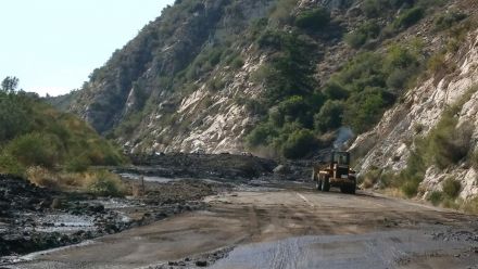
Highway 38 is also now open from Lake Williams to Angelus Oaks, with access up through Big Bear.... and here's why...
Mud & debirs came down onto Hwy 38 up to 100 wide and 10+ feet deep! It's towards the bottom of highway 38, close to the last big turnout and just above the turnoff to Forest Falls.
CLICK TO ENLARGE
Re: VALLEY FIRE: HWY 38 BETWEEN MTN HOME VILLAGE AND FOREST FALLS
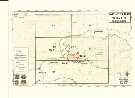
Mtngoat John⭐, Mon Jul 09 2018, 04:53AM
I was asked last night for a new map.
This mornings IAP Index map.
Click on image to enlarge
Re: VALLEY FIRE: HWY 38 BETWEEN MTN HOME VILLAGE AND FOREST FALLS
NShore.Allen, Mon Jul 09 2018, 07:25AM
Where on 38 is the mud flow?
Re: VALLEY FIRE: HWY 38 BETWEEN MTN HOME VILLAGE AND FOREST FALLS
Deb Doodah, Mon Jul 09 2018, 10:33AM
It is after the cutoff to Forest Falls and before Angelus Oaks.
Re: VALLEY FIRE: HWY 38 BETWEEN MTN HOME VILLAGE AND FOREST FALLS
©ammy, Mon Jul 09 2018, 10:56AM
I stopped by the San Bernardino Tanker Base yesterday morning to see what tankers were there and was happy to find these 4!

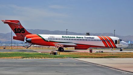

The sun shade on the DC-10 is a minion!

The Valley Fire as seen from Yucaipa yesterday around noon. San Bernardino Peak is the high point hear the center of the image:
Re: VALLEY FIRE: HWY 38 BETWEEN MTN HOME VILLAGE AND FOREST FALLS
MrOwl, Mon Jul 09 2018, 11:29AM
Great shots.
Re: VALLEY FIRE: HWY 38 BETWEEN MTN HOME VILLAGE AND FOREST FALLS
HazMatMind, Mon Jul 09 2018, 05:19PM
Thank you for the tanker shots! 10 yr old grand was so disappointed he didn't get to see them fly over. I sent him the link to your pix.
Re: VALLEY FIRE: HWY 38 BETWEEN MTN HOME VILLAGE AND FOREST FALLS
SCM ALERT🚨, Mon Jul 09 2018, 08:10PM
7-9-2018 8:00PM VALLEY FIRE - EVENING UPDATE
FIRE IS AT 1348 ACRES AND IS STILL 13% CONTAINED
Structures Threatened: 500
Structures Destroyed: 0
Structures Damaged: 0
Injuries: 1
APPARATUS
Engines: 29 Water Tenders: 1 Helicopters: 9 Air Tankers: 0 Hand Crews: 19 Dozers: 4 Other: 60 Total Personnel: 663
VALLEY FIRE ROAD UPDATE 7/9 8:00PM
• Along Hwy 38 only residents with ID are allowed through to the Mountain Home Village, Forest Falls, and Angelus Oaks communities. Angelus Oaks will be allowed to travel through the Hwy 38 closure with a pilot car escort starting at 7:00 AM Tuesday.
• No public access between the Valley of the Falls turnout and Angelus Oaks on Highway 38 due to continued fire activity.
• Highway 38 from Lake Williams Boulevard to Sugar Pines Circle south of Angelus Oaks is open to residents and campers. Public campgrounds and organizational camps are open, including the Barton Flats area.
• Highway 38 from the Big Bear side (330/18/38) is the only access to Angelus Oaks and Barton Flats for the general public.
Re: VALLEY FIRE: HWY 38 BETWEEN MTN HOME VILLAGE AND FOREST FALLS
SCM ALERT🚨, Mon Jul 09 2018, 08:28PM
VALLEY FIRE UPDATE - FIRE, ROAD, AND COMPLETE STATUS FROM THE USFS AS OF MON 7/9 AT 8:00PM **IMPORTANT INFO**
SEE ATTACHED PDF FILE BELOW. CLICK TO VIEW IN YOUR PDF READER.
 valley_fire_update_pm_070918.pdf
Re: VALLEY FIRE: HWY 38 BETWEEN MTN HOME VILLAGE AND FOREST FALLS
Mtngoat John⭐, Wed Jul 11 2018, 05:10AM
This mornings IAP Index map.
The containment number should rise in this mornings briefing based on current mapping.
Click on image to enlarge
Re: VALLEY FIRE: HWY 38 BETWEEN MTN HOME VILLAGE AND FOREST FALLS
Benny ⭐, Wed Jul 11 2018, 08:08AM
VALLEY FIRE UPDATE
Date: July 11, 2018 Time: 0800
Fire Information Line: (909) 383-5688
STATUS
Incident Start Date: July 6, 2018
Incident Start Time: 1:33 P.M.
Incident Type: Wildland Fire Cause: Under Investigation
Incident Location: CA-38 x Valley of the Falls Dr., Forest Falls, CA
Acreage: 1348 Containment: 24%
Expected Containment: N/A Injuries: 4
Structures Threatened: 0 Structures Destroyed: 0 Structures Damaged: 0
RESOURCES
Engines: 12 Water Tenders: 1 Helicopters: 8 Hand Crews: 16 Dozers: 1
Total Personnel: 644
Cooperating Agencies: BLM, NPS, California Highway Patrol, California Office of Emergency Services, CALFIRE, CALTRANS, San Bernardino County Animal Control, American Red Cross, So California Edison, San Bernardino County Fire, San Bernardino County Office of Emergency Services.
SITUATION
Current Situation: Fire behavior was quiet overnight. Fire containment increased to 24% since yesterday, but is not expected to increase significantly in the coming days due to steep, rugged terrain preventing firefighters from accessing many portions of the fire. Crews today will be working on chipping cleared brush along Highway 38, constructing fire line, and reinforcing and improving established containment lines. Helicopters will continue dropping water on areas of high heat within the uncontained fire perimeter. Additionally, a portable fire retardant plant has been established to support reinforcement of existing fire retardant lines. While rain yesterday decreased fire activity, fuels continue to be drier than usual for this time of year due to recent drought history. There continues to be a chance for isolated thunderstorms, presenting a risk for strong winds increasing fire activity and/or flash flooding with associated debris and mud flows. A community meeting is scheduled tonight beginning at 7:30 PM at the Angelus Oaks Fire Station.
Road Status:
• Residents of Mountain Home Village, Forest Falls, and Angelus Oaks with ID and proof of residency are allowed through the closure at Hwy 38 and Bryant Street to access their homes. A pilot car will continue to escort traffic on Hwy 38 between the Hwy 38/Valley of the Falls Drive intersection and Angelus Oaks until 7:00 PM tonight. Highway 38 will be open without a pilot car after 7:00 PM.
• Highway 38 is open from Big Bear, CA, to the intersection with Sugar Pines Circle in Angelus Oaks. All campgrounds and organizational camps in the Barton Flats and Heart Bar areas are open, however, these areas are only accessible from Big Bear, utilizing Hwy 330 to Hwy 18, and then south on Hwy 38.
Trail Closures:
• All portions of the San Gorgonio Wilderness managed by USDA Forest Service are closed to entry. This includes the Momyer Trail, Vivian Creek Trail, San Bernardino Peak Trail, Forsee Creek Trail, South Fork Trail, and Aspen Grove Trail.
Lee Beyer
Fire Information Officer on the Valley Fire
Forest Service
Santa Rosa and San Jacinto Mountains National Monument
p: 760-862-9984
c: 951-203-7552
f: 760-862-9240
leebeyer©fs.fed.us
51500 Highway 74
Palm Desert, CA 92260
[Click Here]
Caring for the land and serving people
Re: VALLEY FIRE: HWY 38 BETWEEN MTN HOME VILLAGE AND FOREST FALLS
Mtngoat John⭐, Sat Jul 14 2018, 03:14PM
Valley Fire Closure Area announced
SAN BERNARDINO, Calif. — Officials with San Bernardino National Forest today announced a forest order creating the Valley Fire Closure Area. The order, effective Saturday, July 14, 2018, temporarily closes a portion of the San Gorgonio Wilderness to all entry due to hazards presented by the Valley Fire near Forest Falls, CA. The order will last until the fire is declared out or until officials re-evaluate conditions and make modifications.
The closure area includes trails, such as Vivian Creek, Momyer, San Bernardino Peak, Forsee Creek, South Fork and Aspen Grove. It does not affect areas outside the wilderness, such as the Big Falls Trail and the Falls Picnic Area. A map of the closure area is available online.
Nearly 650 firefighters from the U.S. Forest Service, CAL FIRE, San Bernardino County Fire and other cooperating agencies worked to slow the fire's spread over the last week, however extremely steep terrain and difficult access have prevented crews from achieving full containment. There are currently 472 personnel assigned to the incident.
Residents and visitors to the area will continue to see smoke for the coming weeks.
Hikers with questions about the closure can call the Mill Creek Visitor Center at 909-382-2882, Thursdays through Mondays. To keep updated on the Valley Fire, check InciWeb, the forest Twitter account and the Valley Fire Updates Facebook group.
Re: VALLEY FIRE: HWY 38 BETWEEN MTN HOME VILLAGE AND FOREST FALLS
Mtngoat John⭐, Mon Jul 16 2018, 06:19AM
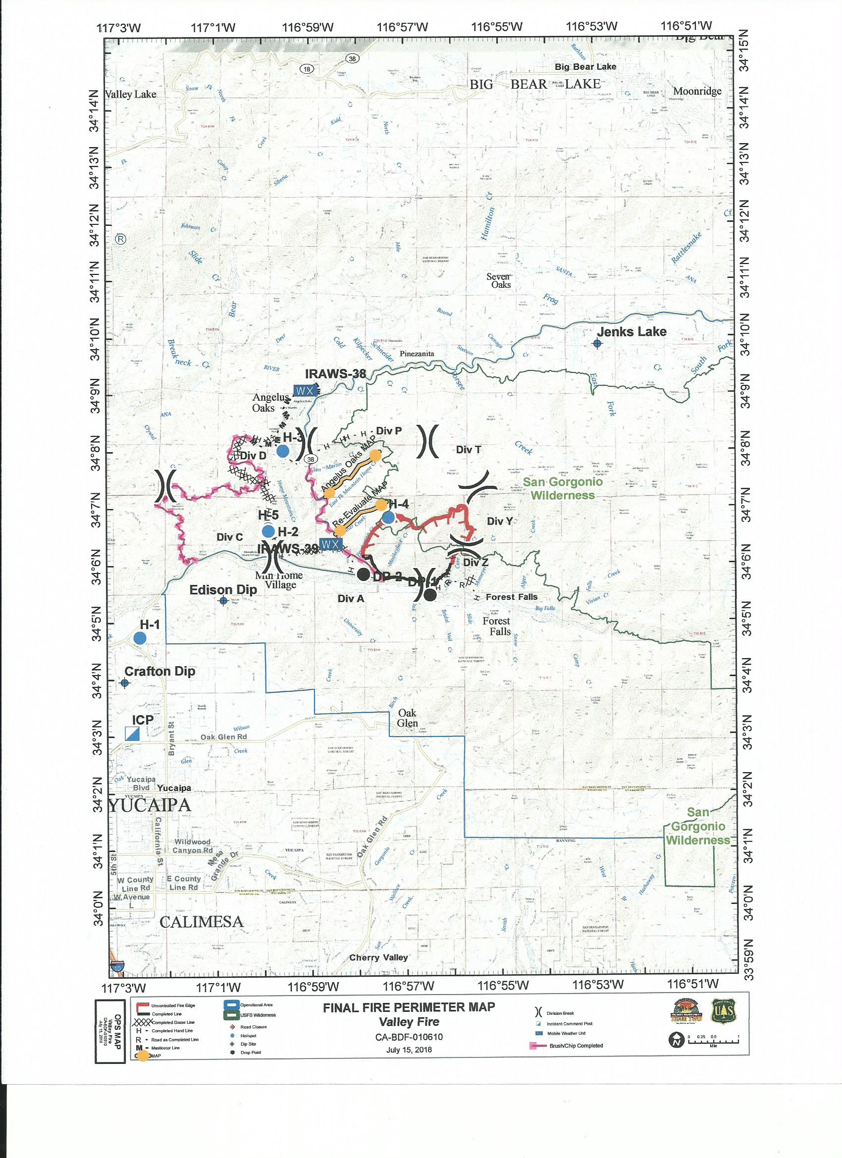
Below is the final fire perimeter map provided by Southern California Incident Management Team Two. As of 6am this morning Valley Fire management transitioned from the Southern California Type 2 Incident Management Team to the San Bernardino National Forest Type 3 Incident Management Team.
Click image to enlarge
Re: VALLEY FIRE: HWY 38 BETWEEN MTN HOME VILLAGE AND FOREST FALLS
Mtngoat John⭐, Mon Jul 16 2018, 04:48PM
Management of Valley Fire transitions back to San Bernardino National Forest.
SAN BERNARDINO, California, July 16, 2018 – Management of the Valley Fire has transferred from a Type 2 incident management team to the San Bernardino National Forest, Front Country Ranger District.
Ten days after it started, management of the Valley Fire has returned to the San Bernardino National Forest. More than 120 fire personnel remain assigned to the fire to patrol and extinguish hot spots along the fire lines, with 4 hand crews, 4 engines, 3 helicopters, 2 water tenders, and support personnel assigned. These resources are available to respond to new incidents upon request. Expect to see smoke from the fire in the upcoming days, possibly weeks, as heavy fuels continue to burning within the fire interior. Smoke may be visible to residents of local communities and to motorists along Highway 38.
National Weather Service forecasts indicate the possibility of thunderstorms generating periods of heavy precipitation in the fire area through Thursday. Should thunderstorms occur over the fire area, an increased risk of flooding and debris flows may resulting in the closure of affected roads. Travelers are urged to use caution, be alert, and be patient.
The Valley Fire began on July 6th, causing road closures and evacuation orders in the Forest Falls area. Currently the fire remains 1,348 acres with 29% containment.
Re: VALLEY FIRE: HWY 38 BETWEEN MTN HOME VILLAGE AND FOREST FALLS
Mtngoat John⭐, Sat Jul 21 2018, 10:56AM
Valley Fire remains active as hotter and drier weather approaches
SAN BERNARDINO, Calif. — Fifteen days after it started, the Valley Fire is still active in very steep, rugged terrain, difficult and dangerous for firefighters. Fire activity has been minimal over the last week, but smoke may increase as hotter and drier weather conditions persist. Firefighters will continue to patrol and extinguish hot spots and aircraft may be used to reinforce containment lines.
Expect to see smoke from the fire in the upcoming days, possibly weeks, as heavy fuels continue to burn within the fire interior. Smoke may be visible to residents of Forest Falls, other local communities and to motorists along Highway 38.
The National Weather Service forecasts seasonally warm weather through the weekend and warns of excessive heat next week. Should thunderstorms occur over the fire area, an increased risk of flooding and debris flows may result in the closure of Highway 38, Valley of the Falls Drive and any other impacted roads. Travelers are urged to use caution, be alert and be patient.
The Valley Fire began during record hot temperatures on July 6, causing road closures and evacuation orders in the Forest Falls area.
Currently the fire remains 1,348 acres with 29% containment. For more information, please visit [Click Here] and follow the forest on Facebook or Twitter.
Re: VALLEY FIRE: HWY 38 BETWEEN MTN HOME VILLAGE AND FOREST FALLS
Mtngoat John⭐, Thu Jul 26 2018, 07:40AM
According to the National Interagency Coordination Center the estimated containment date for the Valley Fire is now November 1st 2018.
Re: VALLEY FIRE: HWY 38 BETWEEN MTN HOME VILLAGE AND FOREST FALLS
Socalman, Tue Jul 31 2018, 05:31PM
Anyone have an update on the acreage for this fire. The big news on tv and radio is, of course, the Redding Fire and the Idylwild fire, followed by the Cranston? (Yosemite) fire.
Re: VALLEY FIRE: HWY 38 BETWEEN MTN HOME VILLAGE AND FOREST FALLS
MrOwl, Tue Jul 31 2018, 05:46PM
Cranston is the one near Idylwild and Ferguson is the one near Yosemite.
Latest stat on Valley Fire:Incident Type: Wildfire
Updated: 7 hrs. ago
Size: 1,350 Acres
Contained: 30%
Re: VALLEY FIRE: HWY 38 BETWEEN MTN HOME VILLAGE AND FOREST FALLS
Benny ⭐, Fri Aug 03 2018, 07:46PM
Valley Fire is up to 56% containment and holding at 1350 acres. Helicopters continue drops as needed. Air attack is doing additional IR mapping as there have been a few hot spots, specifically in Frustration Creek below San Bernardino Peak.
Re: VALLEY FIRE: HWY 38 BETWEEN MTN HOME VILLAGE AND FOREST FALLS
SCM ALERT🚨, Wed Aug 15 2018, 05:02PM
#### Valley Fire containment increases, some hiking areas to reopen ####
SAN BERNARDINO, Calif. — Containment on the Valley Fire in the San Bernardino Mountains has been increased to 82% from 56%, officials with San Bernardino National Forest announced today. The 1,350-acre fire, which started on July 6 near Forest Falls, CA, continues to burn in steep, inaccessible terrain. Ground and air resources remain assigned to the fire and its cause is still under investigation.
The increase in containment has prompted a new forest order, which reduces the footprint of the Valley Fire Closure Area beginning Wednesday, August 15, 2018. The new order allows a number of popular trails, backcountry campsites and destinations to be accessed again in the San Gorgonio Wilderness of Sand to Snow National Monument, which is co-managed by the U.S. Forest Service and Bureau of Land Management.
Trails to reopen include Vivian Creek Trail, the popular route to the summit of San Gorgonio Mountain, the highest in Southern California at approximately 11,500 feet, and South Fork Trail, which brings hikers to its eponymous meadows and a couple of lakes.
Trail closures that remain include the wilderness portions of San Bernardino Peak Trail, including the peak itself, Momyer Trail (pronounced Mo-Meyer) and Foresee Creek Trail, including John's Meadow.
A map of the new Valley Fire Closure Area is attached.
"I want to thank the public for their patience during the closure over the last month," said Front Country District Ranger Joe Rechsteiner. "The remaining closure area is for the public's safety. If the fire flares up and heads deeper into the wilderness, visitors could be put at risk. Unlike areas along Highway 38, getting firefighters into the wilderness can take longer."
The closure area is set to expire on December 31, 2018, but Rechsteiner and staff will continually revisit the possibility of reducing the footprint based on increased containment and conditions on the ground.
Residents and visitors to the area may continue to see smoke coming from the burn area.
Hikers with questions about the closure can call the Mill Creek Visitor Center at 909-382-2882, Thursdays through Mondays or the forest headquarters at 909-382-2600 Mondays through Fridays. To keep updated on the Valley Fire, check InciWeb, the forest Twitter account and the Valley Fire Updates Facebook group.
Re: VALLEY FIRE: HWY 38 BETWEEN MTN HOME VILLAGE AND FOREST FALLS
SCM ALERT🚨, Wed Aug 15 2018, 05:30PM
Valley Fire Closure Map (see attached PDF for map of Valley Fire Closure area).
2018_valleyfire_closure_map_081518.pdf
Re: VALLEY FIRE: HWY 38 BETWEEN MTN HOME VILLAGE AND FOREST FALLS
Mtngoat John⭐, Thu Aug 30 2018, 07:38AM
San Gorgonio Wilderness reopened
SAN BERNARDINO, Calif. — The Valley Fire Closure Area will be lifted on today, Thursday, August 30, 2018, San Bernardino National Forest officials have announced. The action, which is officially the termination of Forest Order 12-18-06, effectively reopens all portions of the San Gorgonio Wilderness previously closed due to the Valley Fire, which began on July 6 near the community of Forest Falls, Calif.
While the 1,350-acre fire with 82% containment remains in steep, inaccessible terrain, recent hot spells and dry weather have not produced any new smoke or flame activity. The fire remains in patrol status with full containment expected after the first significant precipitation event of fall or winter. The fire’s cause remains under investigation.
Trails to reopen include San Bernardino Peak, Momyer (pronounced Mo-Meyer) and Foresee Creek, and previously booked permits for overnight camping in the wilderness will remain valid.
Hikers with questions about the reopening can call the Mill Creek Visitor Center at 909-382-2882, Thursdays through Mondays or the forest headquarters at 909-382-2600 Mondays through Fridays. To keep updated on the Valley Fire, check InciWeb, the forest Twitter account and the Valley Fire Updates Facebook group.
Re: VALLEY FIRE: HWY 38 BETWEEN MTN HOME VILLAGE AND FOREST FALLS
Mtngoat John⭐, Mon Oct 22 2018, 05:14PM
Containment on Valley Fire reaches 100 percent
SAN BERNARDINO, Calif. — The Valley Fire was declared 100 percent contained at 4 p.m. today October 22nd, San Bernardino National Forest officials announced. The decision was based on infrared flights, recent weather, especially significant rainfall on Oct. 13, and no recent reports of smoke and flame activity.
The Valley Fire, the cause which remains under investigation, began on July 6 at approximately 1:30 p.m. near the intersection of Highway 38 and Valley of the Falls Drive, outside the community of Forest Falls, Calif. It burned 1,350 acres in the forest and up steep cliffs into the San Gorgonio Wilderness of Sand to Snow National Monument. That steep terrain made the fire area inaccessible to personnel, prolonging full containment.
All trails into the wilderness were reopened on Aug. 30. Hikers with questions can call the Mill Creek Visitor Center at 909-382-2882, Thursday through Sunday, or the forest headquarters at 909-382-2600 Monday through Friday.
SCM ALERT🚨, Fri Jul 06 2018, 01:36PM
7/6/2018 - VALLEY FIRE MEDIA AND UPDATES HERE - POST ANY MEDIA / DISCUSSION HERE
13:30 HOURS - 1/4 ACRE
Re: VALLEY FIRE: HWY 38 BETWEEN MTN HOME VILLAGE AND FOREST FALLS
NShore.Allen, Fri Jul 06 2018, 01:45PM
when was the last time this side burned?
Re: VALLEY FIRE: HWY 38 BETWEEN MTN HOME VILLAGE AND FOREST FALLS
SCM ALERT🚨, Fri Jul 06 2018, 01:45PM
RAPID RATE OF SPREAD - SEVERAL ACRES - MOVING UPSLOPE TOWARD FOREST FALLS. NO STRUCTURE THREAT AT THIS TIME. SIGNIFICANT MULTI-AGENCY RESPONSE ON SCENE OR ENROUTE
Re: VALLEY FIRE: HWY 38 BETWEEN MTN HOME VILLAGE AND FOREST FALLS
Benny ⭐, Fri Jul 06 2018, 01:57PM
Smoke is visible coming up over the San Gorgonio Wilderness to our south. Fire is no threat at all to the Big Bear Valley.
Live San G Webcam [Click Here]
Re: VALLEY FIRE: HWY 38 BETWEEN MTN HOME VILLAGE AND FOREST FALLS
MrOwl, Fri Jul 06 2018, 02:07PM
Firefighters can't catch a break.
Re: VALLEY FIRE: HWY 38 BETWEEN MTN HOME VILLAGE AND FOREST FALLS
SCM ALERT🚨, Fri Jul 06 2018, 02:08PM
Webcam showing the fire: [Click Here]
Re: VALLEY FIRE: HWY 38 BETWEEN MTN HOME VILLAGE AND FOREST FALLS
SCM ALERT🚨, Fri Jul 06 2018, 02:22PM
HUGE PLUME OF SMOKE ON THE SAN G CAMERA FROM THIS FIRE:
[Click Here]
Re: VALLEY FIRE: HWY 38 BETWEEN MTN HOME VILLAGE AND FOREST FALLS
doo·hick·ey, Fri Jul 06 2018, 02:25PM
Little mushroom cloud at times. Stay safe everybody.

Re: VALLEY FIRE: HWY 38 BETWEEN MTN HOME VILLAGE AND FOREST FALLS
SCM ALERT🚨, Fri Jul 06 2018, 02:27PM
SAN G CAM OF THE VALLEY FIRE AS OF 2:30PM

Re: VALLEY FIRE: HWY 38 BETWEEN MTN HOME VILLAGE AND FOREST FALLS
SCM ALERT🚨, Fri Jul 06 2018, 02:38PM
Webcam view from Mountain Home Village: [Click Here]
Re: VALLEY FIRE: HWY 38 BETWEEN MTN HOME VILLAGE AND FOREST FALLS
doo·hick·ey, Fri Jul 06 2018, 02:47PM
The base got wider and moved west a bit. Looks to be knocked down some. Baldwin winds are coming from the EAST se.

Re: VALLEY FIRE: HWY 38 BETWEEN MTN HOME VILLAGE AND FOREST FALLS
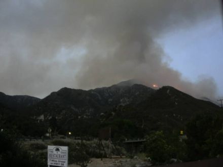
SCM ALERT🚨, Fri Jul 06 2018, 03:02PM
Picture from ABC7 news helicopter:
The group of fire vehicles is right at the junction of Hwy. 38 & Valley Of The Falls Drive.
Re: VALLEY FIRE: HWY 38 BETWEEN MTN HOME VILLAGE AND FOREST FALLS
Benny ⭐, Fri Jul 06 2018, 03:13PM
A few more pics.... Valley Fire now over 100 acres with significant growth potential running into the forest.


Re: VALLEY FIRE: HWY 38 BETWEEN MTN HOME VILLAGE AND FOREST FALLS
Mtngoat John⭐, Fri Jul 06 2018, 03:34PM
Current view from Mountain Home
Re: VALLEY FIRE: HWY 38 BETWEEN MTN HOME VILLAGE AND FOREST FALLS
doo·hick·ey, Fri Jul 06 2018, 05:07PM
The smoke plume has nearly reached to over the dump.
Re: VALLEY FIRE: HWY 38 BETWEEN MTN HOME VILLAGE AND FOREST FALLS
Mtngoat John⭐, Fri Jul 06 2018, 05:37PM
Photo courtesy Gina Ferazzi twitter
SBSO escorting residents out of Forest Falls
Re: VALLEY FIRE: HWY 38 BETWEEN MTN HOME VILLAGE AND FOREST FALLS
©ammy, Fri Jul 06 2018, 06:03PM
Several screenshots from ABC7 helicopter video from about 15-20 minutes ago:
(Click on images to enlarge)


Source: ABC7.com/live
Re: VALLEY FIRE: HWY 38 BETWEEN MTN HOME VILLAGE AND FOREST FALLS
doo·hick·ey, Fri Jul 06 2018, 06:56PM
Winds have been from the South, getting some ash (on my fresh paint) Good luck to all involved.
Re: VALLEY FIRE: HWY 38 BETWEEN MTN HOME VILLAGE AND FOREST FALLS
©ammy, Fri Jul 06 2018, 06:57PM
Just caught this retardant drop on the Mtn Home Village cam:
(click on image to enlarge)

Source: [Click Here]
Re: VALLEY FIRE: HWY 38 BETWEEN MTN HOME VILLAGE AND FOREST FALLS
SCM ALERT🚨, Fri Jul 06 2018, 06:58PM
Great shots Cammy!! Nice catch on that drop!
Re: VALLEY FIRE: HWY 38 BETWEEN MTN HOME VILLAGE AND FOREST FALLS
SCM ALERT🚨, Fri Jul 06 2018, 07:04PM
PHOTO FROM THE VALLEY FIRE COURTESY OF FIRE PHOTOGRAPHER EPN105 (CY)
Re: VALLEY FIRE: HWY 38 BETWEEN MTN HOME VILLAGE AND FOREST FALLS
©ammy, Fri Jul 06 2018, 07:05PM
NShore.Allen wrote ...
when was the last time this side burned?
when was the last time this side burned?
Thanks to MtnGoatJohn sending me a Google Earth file, I was able to find that the area this fire is moving toward last burned in 1977, but there is no record of the area burning where the fire started and is currently burning. And this record goes back to 1878. But I don't know how complete the record is.
In the screenshot below, today's fire started just east of the hairpin turn on Hwy 38 that's just above the "1995" near the lower left of the image:
(click on image to enlarge)

Re: VALLEY FIRE: HWY 38 BETWEEN MTN HOME VILLAGE AND FOREST FALLS
SCM ALERT🚨, Fri Jul 06 2018, 07:11PM
Thanks Cammy! Beyond that 1977 burn isn't the the Lake Fire Burn area behind that?
Re: VALLEY FIRE: HWY 38 BETWEEN MTN HOME VILLAGE AND FOREST FALLS
Polar 🌌rbit, Fri Jul 06 2018, 07:25PM
Lake fire was behind and east. Let;s see if I can paste it here.
Re: VALLEY FIRE: HWY 38 BETWEEN MTN HOME VILLAGE AND FOREST FALLS
©ammy, Fri Jul 06 2018, 07:25PM
Yes.
But that burn scar wasn't listed on this map which only went up through 2013.
Re: VALLEY FIRE: HWY 38 BETWEEN MTN HOME VILLAGE AND FOREST FALLS
Polar 🌌rbit, Fri Jul 06 2018, 07:37PM
How do I attach a jpeg?
Re: VALLEY FIRE: HWY 38 BETWEEN MTN HOME VILLAGE AND FOREST FALLS
doo·hick·ey, Fri Jul 06 2018, 07:58PM
'Choose File' from below
It's kind of getting it's own weather cell up there on top.

Re: VALLEY FIRE: HWY 38 BETWEEN MTN HOME VILLAGE AND FOREST FALLS
Polar 🌌rbit, Fri Jul 06 2018, 08:09PM
OK, maybe got it this time. Lake fire three years ago.
Re: VALLEY FIRE: HWY 38 BETWEEN MTN HOME VILLAGE AND FOREST FALLS
SCM ALERT🚨, Fri Jul 06 2018, 08:11PM
Oh Cool! Thanks Polar! I know it was 3 years ago but that Lake Fire burnt everything I think (mostly timber I think). Maybe that will stop this fire from getting out that way.?
Re: VALLEY FIRE: HWY 38 BETWEEN MTN HOME VILLAGE AND FOREST FALLS
Benny ⭐, Fri Jul 06 2018, 08:13PM
doo·hick·ey wrote ...
'Choose File' from below
It's kind of getting it's own weather cell up there on top.
'Choose File' from below
It's kind of getting it's own weather cell up there on top.
Nice pyrocumulus, if it gets tall enough, it could spark some lightning or a shower.... As the monsoon flow increases through the weekend, humidity should recover and we could see some precip across the mountain top district. Unfortunately, with that comes the potential for strong, erratic winds and lightning.
Re: VALLEY FIRE: HWY 38 BETWEEN MTN HOME VILLAGE AND FOREST FALLS
©ammy, Fri Jul 06 2018, 08:30PM
As night approaches, we're starting to see flames on these 2 webcams:


webcams: [Click Here] [Click Here]
Re: VALLEY FIRE: HWY 38 BETWEEN MTN HOME VILLAGE AND FOREST FALLS
Lumber Jill, Fri Jul 06 2018, 09:03PM
Forest Service Press Release:
Multiple Fires start on the San Bernardino National Forest
SAN BERNARDINO, California, July 6, 2018 –Firefighters from multiple agencies battled record high temperatures and dry conditions in their attempts to control several brush fires on the San Bernardino National Forest.
The Valley Fire quickly grew to 1000 acres as of 8:00 PM after starting at 1:42 in the afternoon. US Forest Service, CAL FIRE, San Bernardino County Fire and San Bernardino County Sheriffs are in Unified Command, working together to suppress the Valley Fire. Mandatory evacuation orders were issued for the community of Forest Falls by the San Bernardino County Sheriff’s office. Structure protection and security are in place if winds push the fire closer to the community. An emergency shelter for displaced residents opened at the Inland Leaders Charter School, 12375 California Street in Yucaipa. Highway 38 is closed to all traffic from Bryant Street in Yucaipa, to Lake Williams Drive near Big Bear. Several trailheads and recreation sites in the Forest Falls have been closed. A specialized Incident Management Team has been requested by the Forest Service to manage this fire.
The Box Fire, which began on the I-15 near Devore, grew to 100 acres before firefighting efforts were able to slow the blaze. Two lanes of I-15 were closed for several hours, leading to traffic congestion for local freeways leading north into the high desert.
Additional fires were reported in the Cajon Pass, and in south Palm Springs near the entrance to Indian Canyon, a popular winter hiking area.
For more information please visit us at [Click Here] , call us at 909-383-5688 or follow us on Twitter at: [Click Here]
Quick Fire Facts: Valley Fire
Fire Start Date: July 6, 2018
Fire Report Time: 1:42 PM
Location: Valley of the Falls Drive, Highway 38,
Acres: 1000 acres,
Fire Cause: Under Investigation
Fire Fighters Assigned: 500
Road Closures: Hwy 38 from Bryant Street to Lake Williams Drive
Evacuations: Community of Forest Falls, including Organization Camps.
Weather: Near record high temperatures, low humidity.
Terrain: Steep, inaccessible mountainsides.
Cooperating Agencies: CAL FIRE, San Bernardino County Fire, San Bernardino County Sheriffs, CHP
Quick Fire Facts: Box Fire
Fire Start Date: July 6, 2018
Fire Report Time: 9:55 AM
Location: Cajon Pass
Acres: 100 acres, 15% contained.
Fire Cause: Under Investigation
Fire Fighters Assigned: 100
Fire Engines: 12
Fire Crews: 3
Road Closures: Two lanes of Northbound 1-15.
Weather: Near record high temperatures, low humidity.
Terrain: Steep, brushy hillsides.
Cooperating Agencies: CAL FIRE, San Bernardino County Fire, CHP.
Re: VALLEY FIRE: HWY 38 BETWEEN MTN HOME VILLAGE AND FOREST FALLS
Benny ⭐, Sat Jul 07 2018, 01:13AM
A few great shots from our field photographer on Friday. Courtesy Cy! Twitter - @epn105

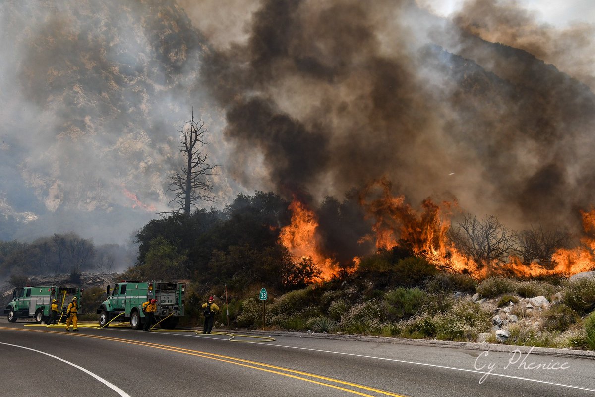

Thanks Cy! Stay safe!
Re: VALLEY FIRE: HWY 38 BETWEEN MTN HOME VILLAGE AND FOREST FALLS
SCM ALERT🚨, Sat Jul 07 2018, 07:53AM
Fire map from this morning's briefing:
(click on image to enlarge)
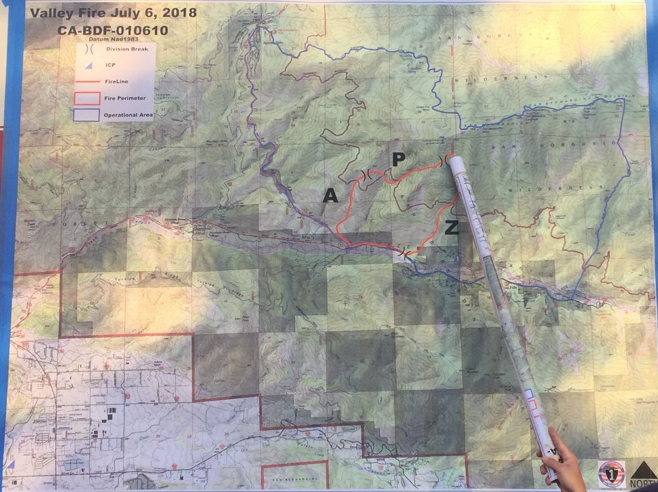
Photo source: [Click Here]
Re: VALLEY FIRE: HWY 38 BETWEEN MTN HOME VILLAGE AND FOREST FALLS
Socalman, Sat Jul 07 2018, 08:41AM
I was just told by a camp employee in Angelus Oaks that we could get to Ceadar Falls if we tell them we are only going to Angelus Oaks. CAN ANYONE CONFIRM THIS REPORT?
Re: VALLEY FIRE: HWY 38 BETWEEN MTN HOME VILLAGE AND FOREST FALLS
Mtngoat John⭐, Sat Jul 07 2018, 09:06AM
Fire map from Inciweb
Click image to enlarge

Re: VALLEY FIRE: HWY 38 BETWEEN MTN HOME VILLAGE AND FOREST FALLS
SCM ALERT🚨, Sat Jul 07 2018, 09:18AM
Socalman wrote ...
I was just told by a camp employee in Angelus Oaks that we could get to Ceadar Falls if we tell them we are only going to Angelus Oaks. CAN ANYONE CONFIRM THIS REPORT?
I was just told by a camp employee in Angelus Oaks that we could get to Ceadar Falls if we tell them we are only going to Angelus Oaks. CAN ANYONE CONFIRM THIS REPORT?
Do you have a way to contact anyone at Camp Cedar Falls to find out what they've been told about closures? From what I understand, IF they're going to let anyone through the closures, it would be residents only with ID to get from say the closure at Bryant/Hwy 38 to Mountain Home Village.
Re: VALLEY FIRE: HWY 38 BETWEEN MTN HOME VILLAGE AND FOREST FALLS
SCM ALERT🚨, Sat Jul 07 2018, 09:55AM
Video - driving out of Forest Falls yesterday afternoon: [Click Here]
Re: VALLEY FIRE: HWY 38 BETWEEN MTN HOME VILLAGE AND FOREST FALLS
SCM ALERT🚨, Sat Jul 07 2018, 11:01AM
Thats a SCARY drive! Thanks for sharing that.
Re: VALLEY FIRE: HWY 38 BETWEEN MTN HOME VILLAGE AND FOREST FALLS
SCM ALERT🚨, Sat Jul 07 2018, 11:20AM
Photo of Valley Fire from yesterday when it was burning hot...
(Courtesy Inciweb - click to enlarge)

Re: VALLEY FIRE: HWY 38 BETWEEN MTN HOME VILLAGE AND FOREST FALLS
Polar 🌌rbit, Sat Jul 07 2018, 12:31PM
Looks like Baldwin Lake won't be an oxymoron for a day or so. Also, looks like valley fire is getting some good rain, at least on the west end. Now we get mudslides.

Re: VALLEY FIRE: HWY 38 BETWEEN MTN HOME VILLAGE AND FOREST FALLS
SCM ALERT🚨, Sat Jul 07 2018, 12:41PM
It never ends for us does it? When the fire isn't burning the mud is flowing. When nothing else is going on the earth is shaking. We just can't catch a break
Re: VALLEY FIRE: HWY 38 BETWEEN MTN HOME VILLAGE AND FOREST FALLS
Benny ⭐, Sat Jul 07 2018, 12:45PM
Did receive some heavy rainfall over the Valley fire today from a strong to severe thunderstorm in the area. Most areas in the east end of the Valley also picked up around an inch of rain.
Re: VALLEY FIRE: HWY 38 BETWEEN MTN HOME VILLAGE AND FOREST FALLS
SCM ALERT🚨, Sat Jul 07 2018, 01:44PM
©ammy wrote ...
Thanks to MtnGoatJohn sending me a Google Earth file, I was able to find that the area this fire is moving toward last burned in 1977, but there is no record of the area burning where the fire started and is currently burning. And this record goes back to 1878. But I don't know how complete the record is.
In the screenshot below, today's fire started just east of the hairpin turn on Hwy 38 that's just above the "1995" near the lower left of the image:
(click on image to enlarge)
NShore.Allen wrote ...
when was the last time this side burned?
when was the last time this side burned?
Thanks to MtnGoatJohn sending me a Google Earth file, I was able to find that the area this fire is moving toward last burned in 1977, but there is no record of the area burning where the fire started and is currently burning. And this record goes back to 1878. But I don't know how complete the record is.
In the screenshot below, today's fire started just east of the hairpin turn on Hwy 38 that's just above the "1995" near the lower left of the image:
(click on image to enlarge)
I just remembered the Momyer Fire from back in 2011 burned APPROXIMATELY in the area outlined in red on the map below. The current Valley Fire is burning APPROXIMATELY west (left) of the Momyer Fire scar and south of (below) the Mitchell Fire area highlighted in green.
Re: VALLEY FIRE: HWY 38 BETWEEN MTN HOME VILLAGE AND FOREST FALLS
SCM ALERT🚨, Sat Jul 07 2018, 01:57PM
Forest Service says 5% containment on the Valley Fire.
Re: VALLEY FIRE: HWY 38 BETWEEN MTN HOME VILLAGE AND FOREST FALLS
SCM ALERT🚨, Sat Jul 07 2018, 02:05PM
Inciweb link for Valley Fire: [Click Here]
Re: VALLEY FIRE: HWY 38 BETWEEN MTN HOME VILLAGE AND FOREST FALLS
SCM ALERT🚨, Sat Jul 07 2018, 05:05PM
PER VALLEY FIRE AIR ATTACK: "FIRE HAS NOT MADE IT TO THE RIDGE YET. QUITE A WAYS FROM IT. WEATHER HAS HELPED US OUT A LOT".
Re: VALLEY FIRE: HWY 38 BETWEEN MTN HOME VILLAGE AND FOREST FALLS
Mtngoat John⭐, Sun Jul 08 2018, 09:34AM
VALLEY FIRE UPDATE
Date: July 8, 2018 Time: 0600
Fire Information Line: (909) 383-5688
STATUS
Incident Start Date: July 6, 2016
Incident Start Time: 1:33 P.M.
Incident Type: Wildland Fire
Cause: Under Investigation
Incident Location: CA-38 x Valley of the Falls Dr, Forest Falls, CA
Acreage: 1,139
Containment: 5%
Expected Containment: N/A
Injuries: 0
Structures Threatened: 500
Structures Destroyed: 0
Structures Damaged: 0
RESOURCES
Engines: 39
Water Tenders: 5
Helicopters: 9
Air Tankers: 8
Hand Crews: 9
Dozers: 2
Other: 60
Total Personnel: 504
Cooperating Agencies: BLM, California Highway Patrol, California Office of Emergency Services, San Bernardino County Office of Emergency Service, CALTRANS, San Bernardino County Animal Control, American Red Cross, Southern California Edison
SITUATION
Current Situation:
The fire is 1,139 acres in size, with 5% containment, moving north and northeast, higher into the San Gorgonio Wilderness Area. Fire remained active throughout the night, and smoke will be visible in the Inland Empire and High Desert. A type 2 team, Southern California Incident Management Team 2, joined unified command of the fire yesterday at 6:00 P.M. Additional firefighting resources also continue to arrive on the fire. Debris flows occurred yesterday on Hwy 38 at milepost 14 due to thunderstorms. Highway 38 remains closed between Bryant St. and Lake Williams and the Forest Falls community is still under mandatory evacuation. Although rain moderated fire behavior yesterday and last night, forest conditions are still very dry due to extended 10-year drought.
Evacuations:
Mandatory Evacuations:
· The community of Forest Falls.
Road Closures:
· Highway 38 from Bryant Street (Yucaipa) to Lake Williams Drive (South of Big Bear) closed to all access including residents.
Trail Closures:
· Momyer Trail, Vivian Creek Trail, San Bernardino Peak Trail & Big Falls Picnic Area.
· A full list of Closed Recreation Sites is available at the San Bernardino National Forest website.
Evacuation Centers:
Animal Shelters:
Evacuation Center: Inland Leaders Charter School, 12375 California St, Yucaipa, CA
Animal Shelter: Devore Animal Shelter,19777 Shelter Way, San Bernardino
Re: VALLEY FIRE: HWY 38 BETWEEN MTN HOME VILLAGE AND FOREST FALLS
Craig ⭐, Sun Jul 08 2018, 11:02AM
Timelapse of the start of the Valley Fire (from the Big Bear San G Camera). Jump ahead to around 1pm to catch the start of the smoke. Look at the difference from the San G cam today and wow, what a difference!
Link to youtube video: [Click Here]
Re: VALLEY FIRE: HWY 38 BETWEEN MTN HOME VILLAGE AND FOREST FALLS
Benny ⭐, Sun Jul 08 2018, 08:10PM
THE EVACUATION ORDER FOR FOREST HOME & FOREST FALLS HAS BEEN LIFTED AND IS NOW OPEN TO RESIDENCE ONLY! PROOF OF RESIDENCY WILL BE REQUIRED TO ENTER.
Highway 38 will remain CLOSED between Angelus Oaks and Bryant Street.
Highway 38 is also now open from Lake Williams to Angelus Oaks, with access up through Big Bear.... and here's why...
Mud & debirs came down onto Hwy 38 up to 100 wide and 10+ feet deep! It's towards the bottom of highway 38, close to the last big turnout and just above the turnoff to Forest Falls.
CLICK TO ENLARGE

Re: VALLEY FIRE: HWY 38 BETWEEN MTN HOME VILLAGE AND FOREST FALLS
Mtngoat John⭐, Mon Jul 09 2018, 04:53AM
I was asked last night for a new map.
This mornings IAP Index map.
Click on image to enlarge

Re: VALLEY FIRE: HWY 38 BETWEEN MTN HOME VILLAGE AND FOREST FALLS
NShore.Allen, Mon Jul 09 2018, 07:25AM
Where on 38 is the mud flow?
Benny (N6BWX) wrote ...
THE EVACUATION ORDER FOR FOREST HOME & FOREST FALLS HAS BEEN LIFTED AND IS NOW OPEN TO RESIDENCE ONLY! PROOF OF RESIDENCY WILL BE REQUIRED TO PENTER.
Highway 38 will remain CLOSED between Angelus Oaks and Bryant Street.
Highway 38 is also now open from Lake Williams to Angelus Oaks, with access up through Big Bear.... and here's why.
Re: VALLEY FIRE: HWY 38 BETWEEN MTN HOME VILLAGE AND FOREST FALLS
Deb Doodah, Mon Jul 09 2018, 10:33AM
NShore.Allen wrote ...
Where on 38 is the mud flow?
Where on 38 is the mud flow?
Benny (N6BWX) wrote ...
THE EVACUATION ORDER FOR FOREST HOME & FOREST FALLS HAS BEEN LIFTED AND IS NOW OPEN TO RESIDENCE ONLY! PROOF OF RESIDENCY WILL BE REQUIRED TO PENTER.
Highway 38 will remain CLOSED between Angelus Oaks and Bryant Street.
Highway 38 is also now open from Lake Williams to Angelus Oaks, with access up through Big Bear.... and here's why.
THE EVACUATION ORDER FOR FOREST HOME & FOREST FALLS HAS BEEN LIFTED AND IS NOW OPEN TO RESIDENCE ONLY! PROOF OF RESIDENCY WILL BE REQUIRED TO PENTER.
Highway 38 will remain CLOSED between Angelus Oaks and Bryant Street.
Highway 38 is also now open from Lake Williams to Angelus Oaks, with access up through Big Bear.... and here's why.
It is after the cutoff to Forest Falls and before Angelus Oaks.
Re: VALLEY FIRE: HWY 38 BETWEEN MTN HOME VILLAGE AND FOREST FALLS
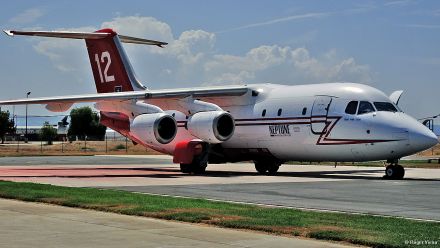
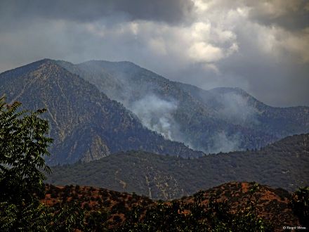
©ammy, Mon Jul 09 2018, 10:56AM
I stopped by the San Bernardino Tanker Base yesterday morning to see what tankers were there and was happy to find these 4!


The sun shade on the DC-10 is a minion!


The Valley Fire as seen from Yucaipa yesterday around noon. San Bernardino Peak is the high point hear the center of the image:
Re: VALLEY FIRE: HWY 38 BETWEEN MTN HOME VILLAGE AND FOREST FALLS
MrOwl, Mon Jul 09 2018, 11:29AM
Great shots.
Re: VALLEY FIRE: HWY 38 BETWEEN MTN HOME VILLAGE AND FOREST FALLS
HazMatMind, Mon Jul 09 2018, 05:19PM
Thank you for the tanker shots! 10 yr old grand was so disappointed he didn't get to see them fly over. I sent him the link to your pix.
Re: VALLEY FIRE: HWY 38 BETWEEN MTN HOME VILLAGE AND FOREST FALLS
SCM ALERT🚨, Mon Jul 09 2018, 08:10PM
7-9-2018 8:00PM VALLEY FIRE - EVENING UPDATE
FIRE IS AT 1348 ACRES AND IS STILL 13% CONTAINED
Structures Threatened: 500
Structures Destroyed: 0
Structures Damaged: 0
Injuries: 1
APPARATUS
Engines: 29 Water Tenders: 1 Helicopters: 9 Air Tankers: 0 Hand Crews: 19 Dozers: 4 Other: 60 Total Personnel: 663
VALLEY FIRE ROAD UPDATE 7/9 8:00PM
• Along Hwy 38 only residents with ID are allowed through to the Mountain Home Village, Forest Falls, and Angelus Oaks communities. Angelus Oaks will be allowed to travel through the Hwy 38 closure with a pilot car escort starting at 7:00 AM Tuesday.
• No public access between the Valley of the Falls turnout and Angelus Oaks on Highway 38 due to continued fire activity.
• Highway 38 from Lake Williams Boulevard to Sugar Pines Circle south of Angelus Oaks is open to residents and campers. Public campgrounds and organizational camps are open, including the Barton Flats area.
• Highway 38 from the Big Bear side (330/18/38) is the only access to Angelus Oaks and Barton Flats for the general public.
Re: VALLEY FIRE: HWY 38 BETWEEN MTN HOME VILLAGE AND FOREST FALLS
SCM ALERT🚨, Mon Jul 09 2018, 08:28PM
VALLEY FIRE UPDATE - FIRE, ROAD, AND COMPLETE STATUS FROM THE USFS AS OF MON 7/9 AT 8:00PM **IMPORTANT INFO**
SEE ATTACHED PDF FILE BELOW. CLICK TO VIEW IN YOUR PDF READER.
valley_fire_update_pm_070918.pdfRe: VALLEY FIRE: HWY 38 BETWEEN MTN HOME VILLAGE AND FOREST FALLS
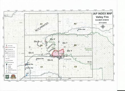
Mtngoat John⭐, Wed Jul 11 2018, 05:10AM
This mornings IAP Index map.
The containment number should rise in this mornings briefing based on current mapping.
Click on image to enlarge

Re: VALLEY FIRE: HWY 38 BETWEEN MTN HOME VILLAGE AND FOREST FALLS
Benny ⭐, Wed Jul 11 2018, 08:08AM
VALLEY FIRE UPDATE
Date: July 11, 2018 Time: 0800
Fire Information Line: (909) 383-5688
STATUS
Incident Start Date: July 6, 2018
Incident Start Time: 1:33 P.M.
Incident Type: Wildland Fire Cause: Under Investigation
Incident Location: CA-38 x Valley of the Falls Dr., Forest Falls, CA
Acreage: 1348 Containment: 24%
Expected Containment: N/A Injuries: 4
Structures Threatened: 0 Structures Destroyed: 0 Structures Damaged: 0
RESOURCES
Engines: 12 Water Tenders: 1 Helicopters: 8 Hand Crews: 16 Dozers: 1
Total Personnel: 644
Cooperating Agencies: BLM, NPS, California Highway Patrol, California Office of Emergency Services, CALFIRE, CALTRANS, San Bernardino County Animal Control, American Red Cross, So California Edison, San Bernardino County Fire, San Bernardino County Office of Emergency Services.
SITUATION
Current Situation: Fire behavior was quiet overnight. Fire containment increased to 24% since yesterday, but is not expected to increase significantly in the coming days due to steep, rugged terrain preventing firefighters from accessing many portions of the fire. Crews today will be working on chipping cleared brush along Highway 38, constructing fire line, and reinforcing and improving established containment lines. Helicopters will continue dropping water on areas of high heat within the uncontained fire perimeter. Additionally, a portable fire retardant plant has been established to support reinforcement of existing fire retardant lines. While rain yesterday decreased fire activity, fuels continue to be drier than usual for this time of year due to recent drought history. There continues to be a chance for isolated thunderstorms, presenting a risk for strong winds increasing fire activity and/or flash flooding with associated debris and mud flows. A community meeting is scheduled tonight beginning at 7:30 PM at the Angelus Oaks Fire Station.
Road Status:
• Residents of Mountain Home Village, Forest Falls, and Angelus Oaks with ID and proof of residency are allowed through the closure at Hwy 38 and Bryant Street to access their homes. A pilot car will continue to escort traffic on Hwy 38 between the Hwy 38/Valley of the Falls Drive intersection and Angelus Oaks until 7:00 PM tonight. Highway 38 will be open without a pilot car after 7:00 PM.
• Highway 38 is open from Big Bear, CA, to the intersection with Sugar Pines Circle in Angelus Oaks. All campgrounds and organizational camps in the Barton Flats and Heart Bar areas are open, however, these areas are only accessible from Big Bear, utilizing Hwy 330 to Hwy 18, and then south on Hwy 38.
Trail Closures:
• All portions of the San Gorgonio Wilderness managed by USDA Forest Service are closed to entry. This includes the Momyer Trail, Vivian Creek Trail, San Bernardino Peak Trail, Forsee Creek Trail, South Fork Trail, and Aspen Grove Trail.
Lee Beyer
Fire Information Officer on the Valley Fire
Forest Service
Santa Rosa and San Jacinto Mountains National Monument
p: 760-862-9984
c: 951-203-7552
f: 760-862-9240
leebeyer©fs.fed.us
51500 Highway 74
Palm Desert, CA 92260
[Click Here]
Caring for the land and serving people
Re: VALLEY FIRE: HWY 38 BETWEEN MTN HOME VILLAGE AND FOREST FALLS
Mtngoat John⭐, Sat Jul 14 2018, 03:14PM
Valley Fire Closure Area announced
SAN BERNARDINO, Calif. — Officials with San Bernardino National Forest today announced a forest order creating the Valley Fire Closure Area. The order, effective Saturday, July 14, 2018, temporarily closes a portion of the San Gorgonio Wilderness to all entry due to hazards presented by the Valley Fire near Forest Falls, CA. The order will last until the fire is declared out or until officials re-evaluate conditions and make modifications.
The closure area includes trails, such as Vivian Creek, Momyer, San Bernardino Peak, Forsee Creek, South Fork and Aspen Grove. It does not affect areas outside the wilderness, such as the Big Falls Trail and the Falls Picnic Area. A map of the closure area is available online.
Nearly 650 firefighters from the U.S. Forest Service, CAL FIRE, San Bernardino County Fire and other cooperating agencies worked to slow the fire's spread over the last week, however extremely steep terrain and difficult access have prevented crews from achieving full containment. There are currently 472 personnel assigned to the incident.
Residents and visitors to the area will continue to see smoke for the coming weeks.
Hikers with questions about the closure can call the Mill Creek Visitor Center at 909-382-2882, Thursdays through Mondays. To keep updated on the Valley Fire, check InciWeb, the forest Twitter account and the Valley Fire Updates Facebook group.
Re: VALLEY FIRE: HWY 38 BETWEEN MTN HOME VILLAGE AND FOREST FALLS
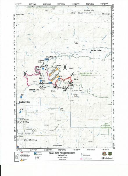
Mtngoat John⭐, Mon Jul 16 2018, 06:19AM
Below is the final fire perimeter map provided by Southern California Incident Management Team Two. As of 6am this morning Valley Fire management transitioned from the Southern California Type 2 Incident Management Team to the San Bernardino National Forest Type 3 Incident Management Team.
Click image to enlarge
Re: VALLEY FIRE: HWY 38 BETWEEN MTN HOME VILLAGE AND FOREST FALLS
Mtngoat John⭐, Mon Jul 16 2018, 04:48PM
Management of Valley Fire transitions back to San Bernardino National Forest.
SAN BERNARDINO, California, July 16, 2018 – Management of the Valley Fire has transferred from a Type 2 incident management team to the San Bernardino National Forest, Front Country Ranger District.
Ten days after it started, management of the Valley Fire has returned to the San Bernardino National Forest. More than 120 fire personnel remain assigned to the fire to patrol and extinguish hot spots along the fire lines, with 4 hand crews, 4 engines, 3 helicopters, 2 water tenders, and support personnel assigned. These resources are available to respond to new incidents upon request. Expect to see smoke from the fire in the upcoming days, possibly weeks, as heavy fuels continue to burning within the fire interior. Smoke may be visible to residents of local communities and to motorists along Highway 38.
National Weather Service forecasts indicate the possibility of thunderstorms generating periods of heavy precipitation in the fire area through Thursday. Should thunderstorms occur over the fire area, an increased risk of flooding and debris flows may resulting in the closure of affected roads. Travelers are urged to use caution, be alert, and be patient.
The Valley Fire began on July 6th, causing road closures and evacuation orders in the Forest Falls area. Currently the fire remains 1,348 acres with 29% containment.
Re: VALLEY FIRE: HWY 38 BETWEEN MTN HOME VILLAGE AND FOREST FALLS
Mtngoat John⭐, Sat Jul 21 2018, 10:56AM
Valley Fire remains active as hotter and drier weather approaches
SAN BERNARDINO, Calif. — Fifteen days after it started, the Valley Fire is still active in very steep, rugged terrain, difficult and dangerous for firefighters. Fire activity has been minimal over the last week, but smoke may increase as hotter and drier weather conditions persist. Firefighters will continue to patrol and extinguish hot spots and aircraft may be used to reinforce containment lines.
Expect to see smoke from the fire in the upcoming days, possibly weeks, as heavy fuels continue to burn within the fire interior. Smoke may be visible to residents of Forest Falls, other local communities and to motorists along Highway 38.
The National Weather Service forecasts seasonally warm weather through the weekend and warns of excessive heat next week. Should thunderstorms occur over the fire area, an increased risk of flooding and debris flows may result in the closure of Highway 38, Valley of the Falls Drive and any other impacted roads. Travelers are urged to use caution, be alert and be patient.
The Valley Fire began during record hot temperatures on July 6, causing road closures and evacuation orders in the Forest Falls area.
Currently the fire remains 1,348 acres with 29% containment. For more information, please visit [Click Here] and follow the forest on Facebook or Twitter.
Re: VALLEY FIRE: HWY 38 BETWEEN MTN HOME VILLAGE AND FOREST FALLS
Mtngoat John⭐, Thu Jul 26 2018, 07:40AM
According to the National Interagency Coordination Center the estimated containment date for the Valley Fire is now November 1st 2018.
Re: VALLEY FIRE: HWY 38 BETWEEN MTN HOME VILLAGE AND FOREST FALLS
Socalman, Tue Jul 31 2018, 05:31PM
Anyone have an update on the acreage for this fire. The big news on tv and radio is, of course, the Redding Fire and the Idylwild fire, followed by the Cranston? (Yosemite) fire.
Re: VALLEY FIRE: HWY 38 BETWEEN MTN HOME VILLAGE AND FOREST FALLS
MrOwl, Tue Jul 31 2018, 05:46PM
Cranston is the one near Idylwild and Ferguson is the one near Yosemite.
Latest stat on Valley Fire:Incident Type: Wildfire
Updated: 7 hrs. ago
Size: 1,350 Acres
Contained: 30%
Re: VALLEY FIRE: HWY 38 BETWEEN MTN HOME VILLAGE AND FOREST FALLS
Benny ⭐, Fri Aug 03 2018, 07:46PM
Valley Fire is up to 56% containment and holding at 1350 acres. Helicopters continue drops as needed. Air attack is doing additional IR mapping as there have been a few hot spots, specifically in Frustration Creek below San Bernardino Peak.
Re: VALLEY FIRE: HWY 38 BETWEEN MTN HOME VILLAGE AND FOREST FALLS
SCM ALERT🚨, Wed Aug 15 2018, 05:02PM
#### Valley Fire containment increases, some hiking areas to reopen ####
SAN BERNARDINO, Calif. — Containment on the Valley Fire in the San Bernardino Mountains has been increased to 82% from 56%, officials with San Bernardino National Forest announced today. The 1,350-acre fire, which started on July 6 near Forest Falls, CA, continues to burn in steep, inaccessible terrain. Ground and air resources remain assigned to the fire and its cause is still under investigation.
The increase in containment has prompted a new forest order, which reduces the footprint of the Valley Fire Closure Area beginning Wednesday, August 15, 2018. The new order allows a number of popular trails, backcountry campsites and destinations to be accessed again in the San Gorgonio Wilderness of Sand to Snow National Monument, which is co-managed by the U.S. Forest Service and Bureau of Land Management.
Trails to reopen include Vivian Creek Trail, the popular route to the summit of San Gorgonio Mountain, the highest in Southern California at approximately 11,500 feet, and South Fork Trail, which brings hikers to its eponymous meadows and a couple of lakes.
Trail closures that remain include the wilderness portions of San Bernardino Peak Trail, including the peak itself, Momyer Trail (pronounced Mo-Meyer) and Foresee Creek Trail, including John's Meadow.
A map of the new Valley Fire Closure Area is attached.
"I want to thank the public for their patience during the closure over the last month," said Front Country District Ranger Joe Rechsteiner. "The remaining closure area is for the public's safety. If the fire flares up and heads deeper into the wilderness, visitors could be put at risk. Unlike areas along Highway 38, getting firefighters into the wilderness can take longer."
The closure area is set to expire on December 31, 2018, but Rechsteiner and staff will continually revisit the possibility of reducing the footprint based on increased containment and conditions on the ground.
Residents and visitors to the area may continue to see smoke coming from the burn area.
Hikers with questions about the closure can call the Mill Creek Visitor Center at 909-382-2882, Thursdays through Mondays or the forest headquarters at 909-382-2600 Mondays through Fridays. To keep updated on the Valley Fire, check InciWeb, the forest Twitter account and the Valley Fire Updates Facebook group.
Re: VALLEY FIRE: HWY 38 BETWEEN MTN HOME VILLAGE AND FOREST FALLS
SCM ALERT🚨, Wed Aug 15 2018, 05:30PM
Valley Fire Closure Map (see attached PDF for map of Valley Fire Closure area).
2018_valleyfire_closure_map_081518.pdfRe: VALLEY FIRE: HWY 38 BETWEEN MTN HOME VILLAGE AND FOREST FALLS
Mtngoat John⭐, Thu Aug 30 2018, 07:38AM
San Gorgonio Wilderness reopened
SAN BERNARDINO, Calif. — The Valley Fire Closure Area will be lifted on today, Thursday, August 30, 2018, San Bernardino National Forest officials have announced. The action, which is officially the termination of Forest Order 12-18-06, effectively reopens all portions of the San Gorgonio Wilderness previously closed due to the Valley Fire, which began on July 6 near the community of Forest Falls, Calif.
While the 1,350-acre fire with 82% containment remains in steep, inaccessible terrain, recent hot spells and dry weather have not produced any new smoke or flame activity. The fire remains in patrol status with full containment expected after the first significant precipitation event of fall or winter. The fire’s cause remains under investigation.
Trails to reopen include San Bernardino Peak, Momyer (pronounced Mo-Meyer) and Foresee Creek, and previously booked permits for overnight camping in the wilderness will remain valid.
Hikers with questions about the reopening can call the Mill Creek Visitor Center at 909-382-2882, Thursdays through Mondays or the forest headquarters at 909-382-2600 Mondays through Fridays. To keep updated on the Valley Fire, check InciWeb, the forest Twitter account and the Valley Fire Updates Facebook group.
Re: VALLEY FIRE: HWY 38 BETWEEN MTN HOME VILLAGE AND FOREST FALLS
Mtngoat John⭐, Mon Oct 22 2018, 05:14PM
Containment on Valley Fire reaches 100 percent
SAN BERNARDINO, Calif. — The Valley Fire was declared 100 percent contained at 4 p.m. today October 22nd, San Bernardino National Forest officials announced. The decision was based on infrared flights, recent weather, especially significant rainfall on Oct. 13, and no recent reports of smoke and flame activity.
The Valley Fire, the cause which remains under investigation, began on July 6 at approximately 1:30 p.m. near the intersection of Highway 38 and Valley of the Falls Drive, outside the community of Forest Falls, Calif. It burned 1,350 acres in the forest and up steep cliffs into the San Gorgonio Wilderness of Sand to Snow National Monument. That steep terrain made the fire area inaccessible to personnel, prolonging full containment.
All trails into the wilderness were reopened on Aug. 30. Hikers with questions can call the Mill Creek Visitor Center at 909-382-2882, Thursday through Sunday, or the forest headquarters at 909-382-2600 Monday through Friday.