Current Weather @ 1:00 PM Clear skies Temp 82.7º Humidity 5% Winds WSW 0.0mph Max Gust 16.1mph
Todays Extremes High 83.1º Low 59.5º Rain 0.00" Rain Rate 0.000" per hr Snow 0.00" Season 55"
ALERTS (click alert for more info)
None at this time
Welcome
Username:

Password:


Remember me

[ ]
[ ]
SUPPORT SCM!
Support SCM by making a single or recurring donation.


ROADS AND TRAFFIC
Updated: 01:00 PM v2.5
Run Spr to Highland  (330): 21 mins  
Highland to Run Spr  (330): 21 mins  
Big Bear to Run Spr    (18): 21 mins  
Run Spr to Big Bear    (18): 21 mins  
Big Bear to Redlands  (38): 68 mins  
Redlands to Big Bear  (38): 68 mins  
Big Bear to Lucerne    (18): 37 mins  
Lucerne to Big Bear    (18): 38 mins  
=Light  =Moderate  =Heavy Traffic
Road Conditions Page: Click Here
Online
Guests: 353, Members: 15 ...
MtnGrumpy
MountainDreamin
Canvas Man
KK
yesstiles
Christopher
Sunny88
McToddy
Zelda
bunnysmom
Scan
onur6boss

most ever online: 3772
(Members: 27, Guests: 3745) on Feb 26 23: 07:51am

Members: 9401
Newest member: MrCabby
Member's Birthdays:

Upcoming Birthdays:
Aug 06 katyclaire
Aug 06 Genevieve
Aug 06 VOFSAR
Aug 06 NAMTAB
Aug 06 EvaJ
Aug 06 KD6VLN
Incident Satellite Map


NO MAP IS AVAILABLE NOT ENOUGH INFORMATION

SUN AUG 3, 2025, 7:35 AM
TRAFFIC HAZARD
CRESTLINE
HIGHWAY 18 at THE NARROWS
7:31AM [2] SMALLER ROCKS IN THE BOTH EAST BOUND AND WESTBOUND LANES
UNITS RESPONDING: CHP (CHP)
NOTES:
TRAFFIC HAZARD-TRAFFIC HAZARD HIGHWAY 18 / THE NARROWS
**ALERT** REPORTED ROCKS IN ROADWAY
WEATHER AT INCIDENT LOCATION: 67 DEGREES WITH 32% HUMDITY. WINDS N AT 5 MPH. PRECIP: NONE
(SOCALMOUNTAINS.COM CAD v13.1)


PHOTOS & MAPS:  

SCM Incident Map
Incident Street View
SCM Incident Map
Incident Satellite Map


INCIDENT UPDATES: 0   


SCANNER AUDIO IS NOT AVAILABLE FROM THIS HOUR


Chatbox
You must be logged in to post comments on this site - please either log in or if you are not registered click here to signup


MountainDreamin
39 second(s) ago
Per this morning's update (936 acres and 0% containment), does the lack of containment mean that the firefighters are allowing fuels to burn in a kind of "guided" manner?

I'm asking because the aerial tankers have been dropping on this fire day and night with incredible dedication, yet there's zero containment. So is this effort more of a controlled burn?

⚡WX ALERT⚡
1 minute(s) ago
I would assume part of the SCE PSPS? We are under a PSPS Watch for the Big Bear Valley, but have a backup line, so ours didn't go out, yet anyway.

Sunny88
6 minute(s) ago
Hi Mountain Hawk, After I reported the outage this morning, SCE sent me an email stating that the power might return by 3:30 pm today. No reason was given for the outage. I’m in Arrowhead.

MountainHawk
10 minute(s) ago
Does anyone know why power is out on westside of the mountain? Sce is terrible at information and never announced a power safety shutoff.

⚡WX ALERT⚡
31 minute(s) ago
Good news McToddy, will keep pushing the fire away and clear out some of this smoke!

McToddy
54 minute(s) ago
The breezes here at the farmer's market is getting pretty gusty

jujubean
1 hour(s) ago
Thanks McToddy! That’s interesting.

McToddy
1 hour(s) ago
Natural gas (for the kilns).... But the plant is pretty barren of combustibles.... To some degree, the plant would be a good fire break

jujubean
1 hour(s) ago
I hope there Isent anything that can explode at the Mitsubishi Plant?

ccthomas
2 hour(s) ago
MountainDreamin, there is a generator onsite at Bertha Peak, powered by propane. I’d hate to have to drive a propane truck up that road to fill those tanks!
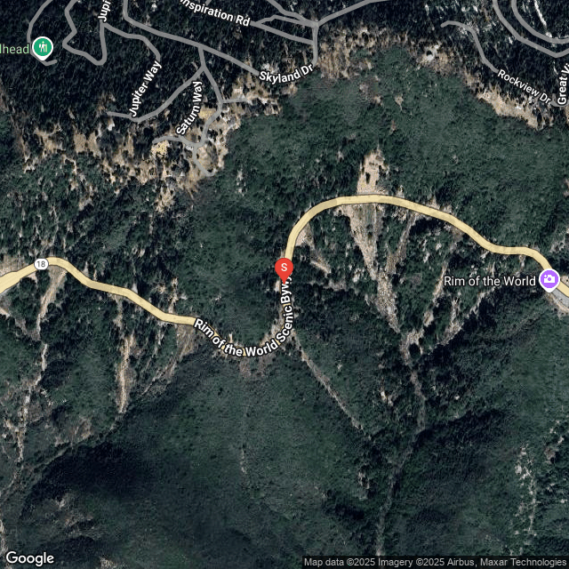
SCM ALERT🚨
2 hour(s) ago
[UPDATE]
GOLD FIRE in BIG BEAR
The Gold Fire Is Officially 936 Acres And Is 0% Contained. The Fire Continues To Move North East Away From The Big Bear Valley. The Fire Continues To Move Closer To The Mitsubishi Cement Plant At The Bottom Of Highway 18 In Lucerne Valley.
DETAILS: [Click Here]

Sunny88
2 hour(s) ago
Oh well. It went out again.

Sunny88
2 hour(s) ago
Mountain Hawk, My power just came back! Hope it stays on and yours comes back too.

McToddy
2 hour(s) ago
👍👍 for no smoke in town

McToddy
2 hour(s) ago
SCM... FYI, I'm get a certificate notification for the site fo https


Latest Forum Posts
Posted by SCM ALERT🚨 in BENSWEATHER REAL-TIME UPDATES
@BensWeather:The #GoldFire has been mapped at 936 acres burned and 0% containmen (Aug 05 25: 11:29am)

Posted by SCM ALERT🚨 in NEWS
@SBCOUNTYFIREFONTANA: #SBCoFD is on-scene of a RESIDENTIAL STRUCTURE FIRE on the (Aug 05 25: 10:39am)

Posted by SCM ALERT🚨 in NEWS
CITY OF BIG BEAR LAKE:📢 Attention #BigBearLake property owners! The Mountain Rim (Aug 05 25: 08:16am)

Posted by SCM ALERT🚨 in NEWS
CITY OF BIG BEAR LAKE:Bear Valley Electric Service (BVES) is notifying customers (Aug 05 25: 08:11am)

Posted by SCM ALERT🚨 in NEWS
@SBCOUNTYFIRERT @CALFIREBDU: #PepperFire Forward progress stopped. @SBCOUNTYFIRE (Aug 05 25: 02:59am)

Posted by SCM ALERT🚨 in NEWS
@CALFIREBDU:#PepperFire Forward progress stopped. @SBCOUNTYFIRE @sbcountysheriff (Aug 05 25: 02:57am)

Posted by SCM ALERT🚨 in NEWS
@CALFIREBDU:#PepperFire can handle with units at scene, cancel balance (Aug 05 25: 02:57am)

Posted by SCM ALERT🚨 in NEWS
@CALFIREBDU:#PepperFire determined to be in unincorporated @SBCounty (Aug 05 25: 02:52am)


(C)2002-2025 Socalmountains.com
All Rights Reserved
Privacy Policy Terms of Service
Contact Us

{THEMEDISCLAIMER}